In January, the U.S. Army Corps of Engineers (USACE) released the North Atlantic Coast Comprehensive Study.

North Atlantic Coast Comprehensive Study
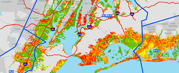
The goals of the study, authorized under the Disaster Relief Appropriations Act, Public Law 113-2 are to reduce flood risk to vulnerable coastal populations, and promote coastal resilient communities to ensure a sustainable and robust coastal landscape system, considering future sea level rise and climate change scenarios. The study area, encompassed approximately 31,200 miles of coastline.
About the Study
The U.S. Army Corps of Engineers recently completed a report detailing the results of a two-year study to address coastal storm and flood risk to vulnerable populations, property, ecosystems, and infrastructure affected by Hurricane Sandy in the United States’ North Atlantic region.
The study, known as the North Atlantic Coast Comprehensive Study, is designed to help local communities better understand changing flood risks associated with climate change and to provide tools to help those communities better prepare for future flood risks. It builds on lessons learned from Hurricane Sandy and attempts to bring to bear the latest scientific information available for state, local, and tribal planners.
Map of study area
The conclusions of the study, as detailed in the final report, include several findings, outcomes, and opportunities, such as the use of a nine-step Coastal Storm Risk Management Framework that can be customized for any coastal watershed.
Geospatial Products:
NACCS geodatabase: This database contains vector GIS information from various NACCS geospatial analyses. It also has features used to generate report maps and figures, including base map features. Refer to ArcGIS metadata for more information about each feature. Click here to request NACCS geodatabase products* (Esri file geodatabase format).
Raster geospatial products: These are raster files presenting results of the NACCS exposure analysis, risk analysis, future mean sea level inundation mapping, and housing density projections. These products were generated using the best available data at the time and may or may not accurately reflect existing or future conditions. Refer to ArcGIS metadata for more information about each file. Click here to request raster geospatial products* (TIFF format).
Barrier Island Sea Level Rise Inundation Assessment: The back bays of barrier islands to the bay side of beaches and dunes as well as other areas of the North Atlantic Coast including embayments and harbors are at risk of storm surge and tidal flooding via barrier island inlets. Long Beach Island, New Jersey was identified for the NACCS Barrier Island and Back Bay Example to present an illustrative example of how a beach and dune system would perform based on sea level change inundation scenarios as well as the impacts of coastal flooding from back bay areas. This example is not intended to evaluate the actual coastal storm risk and consequences. Click here to go to access the report.
Coastal Hazards System: The Coastal Hazards System (CHS) is a coastal storm hazard data storage and mining system. It stores comprehensive, high-fidelity, storm response computer modeling results including climatology, surge, total water levels, waves, and currents and corresponding measurements. Extremal statistics and epistemic uncertainties of the processes are also stored, and the data are easily accessed, mined, plotted, and downloaded through a user-friendly web interface. CHS regional data are comprehensive, uniformly spanning the coastal region and practical probability space. The CHS is available online at https://chs.erdc.dren.mil/.
Sea Level Affecting Marshes Model update algorithm: This algorithm has only been implemented as a stand-alone FORTRAN code; implementation into SLAMM is done by the developers to maintain consistent code management.
Please visit http://www.nad.usace.army.mil/compstudy to learn more about the study.