GIS user technology news

News, Business, AI, Technology, IOS, Android, Google, Mobile, GIS, Crypto Currency, Economics

  • Advertising & Sponsored Posts
    • Advertising & Sponsored Posts
    • Submit Press
  • PRESS
    • Submit PR
    • Top Press
    • Business
    • Software
    • Hardware
    • UAV News
    • Mobile Technology
  • FEATURES
    • Around the Web
    • Social Media Features
    • EXPERTS & Guests
    • Tips
    • Infographics
  • Blog
  • Events
  • Shop
  • Tradepubs
  • CAREERS
You are here: Home / *FEATURES / THE EDITOR / Mapping the Pacific Garbage Patch and Ocean Currents Moving Plastics and Debris

Mapping the Pacific Garbage Patch and Ocean Currents Moving Plastics and Debris

February 3, 2012 By Editor

Are you taking advantage of local meet ups? Recently I dropped in on a lecture at the University of Victoria with my daughter. The presentation titled “The Greatest Infection of The Sea”, sponsored by the U Vic Biology Dept., was all about the state of the oceans and in particular, the alarming amount of plastics that are polluting this resource. It was pretty alarming really, presented by Captain Charles Moore who founded the Algalita Marine Research Foundation in Long Beach, CA. Some amazing items I picked up on: plastics are widespread and largely unseen (hence our feeling that there’s no issue here); fish are feeding on plastics, so much that biologists actually want to incorporate plastic into the food chain diagrams! Pollution comes from many sources, mainly plastic bags, water bottles, and the largest culprit is likely the Korean fisheries. These plastics find their way into the ocean, converge into the Great Garbage Patch and then start a journey navigating the Ocean via a series of currents, resulting in an endless trip and growing cycle of trash. What’s disturbing is the impact this is having on sea life and eventually on the human population.

Some interesting observations and notes from the lecture:

  • Some of the most common fish (in bio-mass) in the sea are consuming plastics (a study showd 35% of those surveyed had plastic present)
  • Fish are becoming weaker and have a lower reproduction rate after ingesting plastics
  • Korean fisheries are the largest commercial polluter of plastics
  • Golf courses by the sea in Hawaii ore littering the nearby shoreline with golf balls (450 found in one spot in just an hour)
  • Many items are not biodegradable when in the ocean
  • Pollutants are resulting in estrogen being introduced into human diets and potentially higher rates of diabetes and obesity
  • Plastic may be introduced into food chain diagrams!
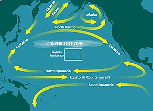
Map of Currents moving the garbage patch – Source: Wikipedia


After hearing the stats and the images I’m more convinced now that I’ll do much more to consume only local product, reduce needless plastics (Why the F do I wrap up perfectly good, bio degradable dog shit in a plastic bag for permanent preservation). Honestly, if I was to go to Hawaii I wouldn’t consume the local fish, its that bad and I definitely won’t be buying any imported frozen fish from Asia, mainly Korea – buy BC, WA State, Alaska fish! If this topic interests you try a Google search (or a DuckDuckGo search) on “The Great Pacific garbage patch“, check out the health effects of BPA and see also http://www.algalita.org

Interesting to note, just as I was penning this blog post I noticed a tweet referencing a map on the LA Times blog of trash that is in the World’s Oceans.. interesting and timely!


Filed Under: THE EDITOR Tagged With: editor, Experts, Glenn Letham, gletham, Mapping the Pacific Garbage Patch and Ocean Currents Moving Plastics and Debris

About Editor

Glenn is a geographer and a GIS professional with over 20 years experience in the industry. He's the co-founder of GISuser and several other technology web publications.

Top Press

The Global Expansion of Aueshah: A New Era of High Jewelry

April 11, 2026 By GISuser

KARACHI, PAKISTAN. The international luxury market is experiencing a profound shift. Consumers are increasingly rejecting mass-produced goods in favor of rarity, authenticity, and emotional depth. … [Read More...]

State of Data Science Report – AI and Open Source at Work

September 10, 2025 By GISuser

AI and Open Source at Work … [Read More...]

Topcon Announces Landmark Expansion of Topnet Live Network Across USA

January 26, 2025 By GISuser

LIVERMORE, Calif.---Topcon Positioning Systems has announced a significant expansion of its Topnet Live reference station network, introducing 200 new geodetic stations strategically positioned across … [Read More...]

Space Flight Laboratory (SFL) Announces Launch and Deployment of NorSat-4 Maritime Monitoring Microsatellite

January 19, 2025 By GISuser

Seventh Satellite Developed by SFL for Norway … [Read More...]

HERE and BMW Group extend partnership on AI-powered mapping system

January 8, 2025 By GISuser

HERE and BMW Group extend partnership on AI-powered mapping system for automated driving and enhanced road safety … [Read More...]

Everest Base Camp Helicopter Tour, Helicopter Return Trek, and Manaslu Circuit Trek: Which Nepal Adventure Is Right for You?

November 6, 2026 By GISuser

Almost everyone planning a Nepal trip runs into the same wall. You want the big mountains, you have a fixed number of days, and every itinerary you read seems to promise something … [Read More...]

SFL Missions Inc. Confirms Successful Deployment of Six HawkEye 360 Radio Frequency Detection Satellites with Advanced Capabilities

October 27, 2026 By GISuser

MĀHIA, New Zealand, 26 October 2026 – SFL Missions Inc. today confirmed the successful deployment of six radio frequency (RF) detection and geolocation satellites for HawkEye 360 … [Read More...]

Canadian-Built RoadEng 12 Uses AI to Find the Best Location for New Resource and Rural Roads

October 17, 2026 By GISuser

Vancouver, BC, Canada, October 15, 2026 – North Vancouver-based Softree Technical Systems today released RoadEng Version 12, used in more than 75 countries to locate and design … [Read More...]

Beyond the Map: How AI Image and Video Generation Is Changing Geospatial Communication

October 14, 2026 By GISuser

Ask anyone who has shipped a GIS project what the hardest part was, and the answer is rarely the spatial analysis. It is almost always the communication. A site suitability … [Read More...]

From Maternity to Everyday Wear: Building a Wardrobe That Grows With You

October 14, 2026 By GISuser

When I think about maternity clothing, I feel the biggest mistake is buying too many things at once. During pregnancy, your body keeps changing, and something that fits well today … [Read More...]

Copyright gletham Communications 2015 - 2026

Go to mobile version