GIS user technology news

News, Business, AI, Technology, IOS, Android, Google, Mobile, GIS, Crypto Currency, Economics

  • Advertising & Sponsored Posts
    • Advertising & Sponsored Posts
    • Submit Press
  • PRESS
    • Submit PR
    • Top Press
    • Business
    • Software
    • Hardware
    • UAV News
    • Mobile Technology
  • FEATURES
    • Around the Web
    • Social Media Features
    • EXPERTS & Guests
    • Tips
    • Infographics
  • Blog
  • Events
  • Shop
  • Tradepubs
  • CAREERS
You are here: Home / News / Google maps, Google earth, Web 2.0 Map Resources / NEW VIDEO GAME AIMS TO CREATE REALISTIC COMBAT DRONE SIMULATOR USING GOOGLE EARTH

NEW VIDEO GAME AIMS TO CREATE REALISTIC COMBAT DRONE SIMULATOR USING GOOGLE EARTH

October 9, 2012 By Editor

Austin, TX, October 9, 2012 – A new game in development promises to leverage the technology of Google Earth to offer players the largest explorable map in video game history.  "Geoception", by Earthling Technology, allows players to command and control UAVs and other combat drones in a realistic manner, anywhere in the world.

Tactical scenarios and missions can be dynamically generated at any location on the globe, providing challenging targets such as armed personnel, moving vehicles, and rooftop sentry guns.  Successful completion of missions earns rewards and medals, with the ultimate goal being to establish total global security.

All game actors can be easily replaced with virtually any Sketchup/3D models of the player’s choosing, allowing a totally customizable gaming experience.  You can replace the drones with dragons, or the soldiers with Smurfs.  It’s your world, and your game.  Craft your own actor models in Sketchup, or choose from a wide selection of free models in 3DWarehouse – even zombies!

And with Google continuously improving the quality of their digital globe behind the scenes, the player is guaranteed an ever-improving game map and environment.  This new concept of "reality gaming" – i.e, gaming in a realistic model of the actual world we live in – truly has the potential to revolutionize the way people think of video games.

More information is available at:

  • http://geoception.com
  • http://www.kickstarter.com/projects/945876709/geoception-reality-gaming-in-google-earth

ABOUT EARTHLING TECHNOLOGY, LLC
Earthling Technology, LLC is an Austin, Texas-based software development company specializing in original video games.  Their first release is Geoception, a novel Google Earth-based game in development that allows the player to command and control combat drones anywhere in the world.


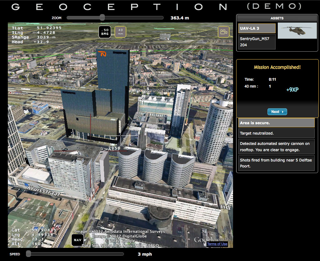
GEOCEPTION: NEW VIDEO GAME AIMS TO CREATE REALISTIC COMBAT DRONE SIMULATOR USING GOOGLE EARTH


Filed Under: Google maps, Google earth, Web 2.0 Map Resources, UAV/UAS Tagged With: Google earth, google maps, NEW VIDEO GAME AIMS TO CREATE REALISTIC COMBAT DRONE SIMULATOR USING GOOGLE EARTH, News, UAS, UAV, Web 2.0 Map Resources

Editor’s Picks

Feature – Oil and Water: Mapping the South China Sea

Event Review, Commercial Drone Expo

Feature: Social Media Mapping is Crucial for Market Research and your Social Strategy

Hardware Spotlight – HP Z240 SFF Turbo Workstation

See More Editor's Picks...

About Editor

Glenn is a geographer and a GIS professional with over 20 years experience in the industry. He's the co-founder of GISuser and several other technology web publications.

Recent Industry News

The Drift Between Early Notes and Final Case Files in Abuse-Related Legal Support

April 29, 2026 By GISuser

Aerial Surveys Int’l and Global Marketing Insights to Present GEOINT 2026 Workshop on Multi-Domain Geospatial Fusion for Automated Infrastructure Monitoring

April 24, 2026 By GISuser

Why Timing Matters More Than You Think With Spray Seal (And Why People Often Get It Slightly Wrong)

April 22, 2026 By GISuser

The Quiet Planning Stage Most People Don’t See When Building a Pool in Brisbane

April 22, 2026 By GISuser

Hot News

State of Data Science Report – AI and Open Source at Work

HERE and AWS Collaborate on New HERE AI Mapping Solutions

Virtual Surveyor Adds Productivity Tools to Mid-Level Smart Drone Surveying Software Plan

Categories

Copyright gletham Communications 2015 - 2026

Go to mobile version