GIS user technology news

News, Business, AI, Technology, IOS, Android, Google, Mobile, GIS, Crypto Currency, Economics

  • Advertising & Sponsored Posts
    • Advertising & Sponsored Posts
    • Submit Press
  • PRESS
    • Submit PR
    • Top Press
    • Business
    • Software
    • Hardware
    • UAV News
    • Mobile Technology
  • FEATURES
    • Around the Web
    • Social Media Features
    • EXPERTS & Guests
    • Tips
    • Infographics
  • Blog
  • Events
  • Shop
  • Tradepubs
  • CAREERS
You are here: Home / cartography / Regional Differences Project – Drawing America's Regions

Regional Differences Project – Drawing America's Regions

August 14, 2013 By Editor

How do you define the Northwest or the Rockies regions of America? Enter The Regional Differences Project – a cool project that lets users enter their definition of regions in an effort to crowd source regional differences and define the spatial makeup of the land… pretty cool! http://www.regionaldifferences.com/

From the project… This project is to collect data on where people think different regions of America are located. People from Texas and Florida have strong views on whether or not they are part of the “South”, while people from Vermont and Connecticut and Georgia have different ideas about “New England”, and the “Midwest” might migrate a thousand miles depending on where you learned the term.

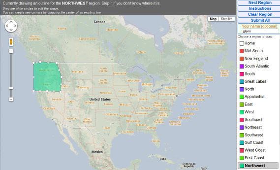
Draw region boundaries as you see them. You can submit as many or as few regions as you’d like.

Filed Under: cartography

Editor’s Picks

Botswana Geoscience Portal goes live

Mobile Data Collection with FulcrumApp and Moving into CartoDB

Hardware Spotlight – HP Z240 SFF Turbo Workstation

Esri Indonesia Story Map Explores Missing AirAsia Flight 8501

See More Editor's Picks...

About Editor

Glenn is a geographer and a GIS professional with over 20 years experience in the industry. He's the co-founder of GISuser and several other technology web publications.

Recent Industry News

The Future of Competitive Gaming: Why DMA Technology is the Ultimate Performance Edge

June 24, 2026 By GISuser

Milwaukee M18FHZ-0 Hackzall Reciprocating Saw – For hardcore cutting in a compact size

June 19, 2026 By GISuser

How Enterprises Are Using AI to Automate 80% of Customer Interactions With Voice Agents

June 16, 2026 By GISuser

Why On Cloud Shoes Are Worth the Price in Mexico

June 16, 2026 By GISuser

Hot News

State of Data Science Report – AI and Open Source at Work

HERE and AWS Collaborate on New HERE AI Mapping Solutions

Virtual Surveyor Adds Productivity Tools to Mid-Level Smart Drone Surveying Software Plan

Categories

Copyright gletham Communications 2015 - 2026

Go to mobile version