A GIS project can have perfect imagery, clean attribute tables and a well-designed symbology, and still go wrong because of one quiet mistake: a mismatched unit of measurement.
Geospatial work pulls data from many sources. Field crews record in feet, satellite products arrive in metres, equipment specs list weight in pounds, and international partners expect kilograms. Every handoff is a chance for a value to be read in the wrong unit.
The result is rarely a dramatic crash. It is usually a parcel boundary that sits a few feet off, a buffer zone that is too small, or a drone that is loaded closer to its limit than the crew thinks. This guide covers where unit errors appear most often in GIS work and simple habits that prevent them.
Length Units: Feet, Metres and the Retired Survey Foot
Length is the unit GIS professionals deal with most, and it hides the most subtle traps.
Two feet that were almost the same
For decades the United States used two versions of the foot. The international foot is exactly 0.3048 metres. The US survey foot was defined as 1200/3937 metres, or about 0.3048006 metres.
The gap is only about 2 parts per million. That sounds harmless, but State Plane coordinates often run into the millions of feet. At that size, mixing the two definitions can shift a point by several feet. 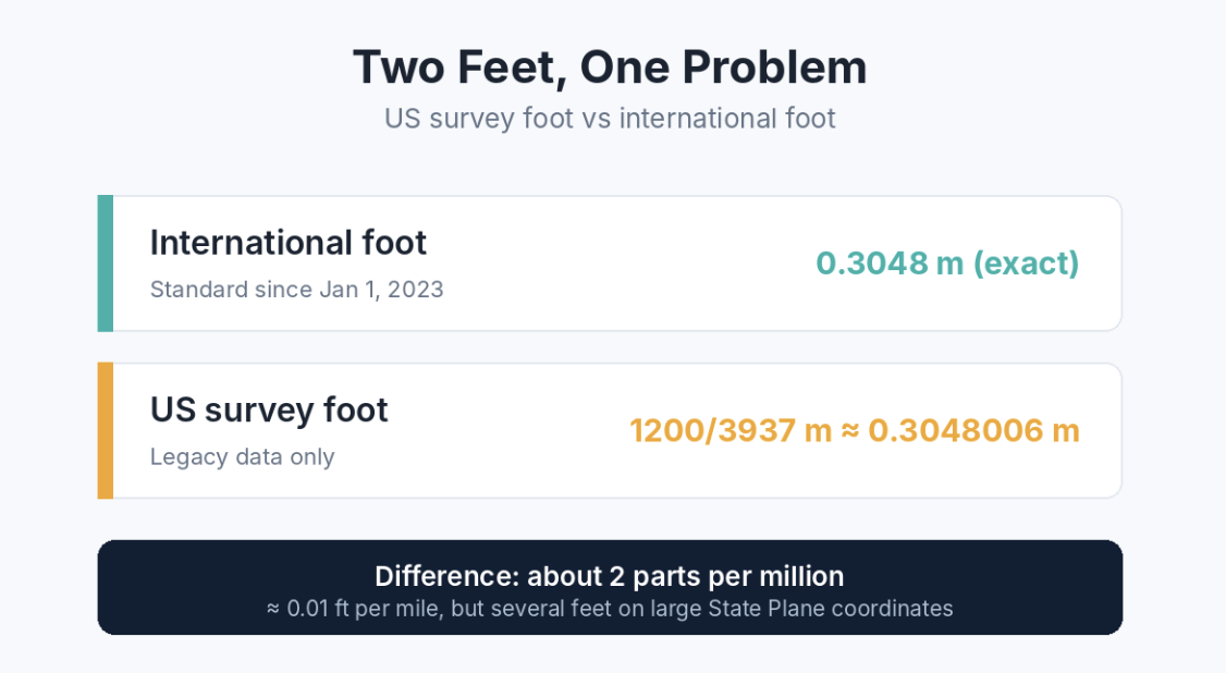
To end this confusion, NIST and the National Geodetic Survey retired the US survey foot at the start of 2023. Since then, “foot” in surveying and mapping means the international foot. The survey foot survives only in legacy data and some existing State Plane definitions.
What this means for you: when you load older datasets, check the metadata. If the projection says “US Feet” and your project uses international feet, the difference must be handled by the coordinate system, not ignored.
Inches and centimetres on printed maps
Unit mix-ups also show up in map layouts. A map scale of 1:24,000 means one unit on paper equals 24,000 of the same unit on the ground. One inch on the map is 24,000 inches, or 2,000 feet.
Trouble starts when a layout is designed in inches but printed or measured in centimetres. One inch is exactly 2.54 cm, so a scale bar drawn for the wrong unit can be off by more than 2.5 times. 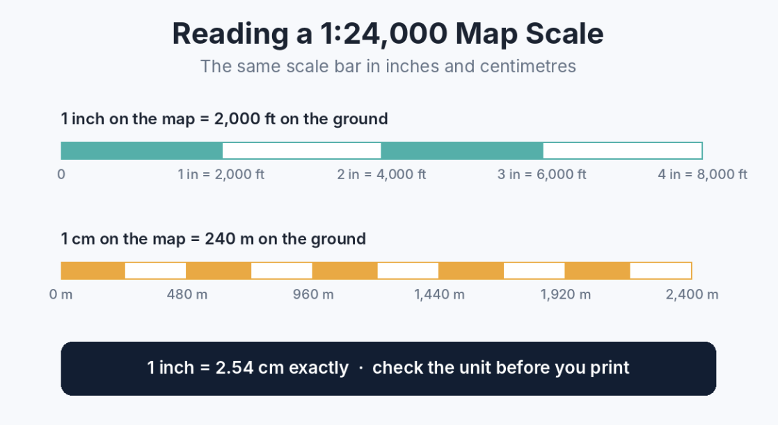
When you set up page sizes, margins or scale bars for clients who work in metric, it helps to double-check values with a simple tool such as Toolsveria’s inches to cm converter before exporting the final layout.
Weight Units: Drone Payloads and Field Equipment
Weight is not the first thing people link with GIS, but it matters more every year as drones become a standard data collection tool.
Drone payload limits
In the United States, commercial drone flights fall under the FAA’s Part 107 rules, which apply to drones weighing less than 55 pounds, including payload. That is about 25 kg.
Most drone and sensor manufacturers publish specs in kilograms, while US regulations and many field checklists use pounds. A survey team adding a LiDAR unit, a multispectral camera and extra batteries needs to total everything in one unit before takeoff.
The conversion factor is fixed: 1 pound equals exactly 0.45359237 kg. In the field, though, nobody wants to do long multiplication on a phone screen. Keeping a bookmarked tool to convert pounds to kilograms saves time and removes rounding guesswork when you compare a sensor spec sheet against a regulatory limit.
Alt text: Drone payload weight in lbs and kg against the FAA Part 107 limit
Shipping and field logistics
Weight also matters outside the air. GNSS base stations, tripods, ground control targets and rugged laptops all travel to remote sites. Courier and airline limits are often given in kilograms, while equipment lists from US suppliers use pounds.
A quick reference for common field weights:
| Item weight (lbs) | Equivalent (kg) |
|---|---|
| 0.55 lbs | 0.25 kg |
| 10 lbs | 4.54 kg |
| 25 lbs | 11.34 kg |
| 50 lbs | 22.68 kg |
| 55 lbs | 24.95 kg |
Practical Habits to Avoid Unit Errors in GIS
Most unit problems are prevented by routine, not by expertise. These habits work for small teams and large agencies alike.
- Record units in the field name or metadata. A column called height_m or weight_kg leaves no room for guessing.
- Check the projection’s linear unit on import. Many GIS tools show it in layer properties. Confirm whether it is metres, international feet or US survey feet.
- Pick one project standard. Decide at the start whether the project works in metric or imperial, and convert incoming data once, at the door.
- Use exact conversion factors. 1 inch = 2.54 cm, 1 foot = 0.3048 m, 1 lb = 0.45359237 kg. Avoid rounded factors in calculations.
- Label everything on the map. Scale bars, legends and area labels should always name the unit.
- Verify with a second method. For critical numbers, recheck with a calculator or online converter before a deliverable goes out.
Quick pre-delivery checklist
- ☐ All layers share the same coordinate system and linear unit
- ☐ Legacy data in US survey feet is handled correctly
- ☐ Scale bar matches the print unit
- ☐ Equipment and payload weights are totalled in one unit
- ☐ Metadata states the unit for every measured field
Conclusion
Units of measurement feel basic, but in GIS they sit underneath every distance, area, buffer and payload calculation. The retirement of the US survey foot, the growth of drone mapping and the global nature of geospatial teams all make conversions more important, not less.
The fix is simple: name your units, standardise early, use exact factors and double-check critical values. A few seconds of checking is far cheaper than redoing a survey or reprinting a map set.