Maxar collected new high resolution satellite imagery yesterday (September 2nd at 11:52 AM, Eastern) that shows historic flooding along the Raritan River in New Jersey. As the remnants of Hurricane Ida moved through the northeast of the United States, the storm dropped record-breaking rainfall causing floods and damage in multiple towns and communities including Somerville, Manville, South Bound Brook and New Brunswick, New Jersey.


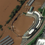


Imagery credit: Satellite image ©2021 Maxar Technologies.