GISuser.com

GIS and Technology news for mapping professionals

  • PRESS
    • Submit PR
    • Top Press
    • Business
    • Software
    • Hardware
    • UAV News
    • Mobile Technology
  • FEATURES
    • Around the Web
    • Social Media Features
    • EXPERTS & Guests
    • Tips
    • Infographics
  • Events
  • CAREERS
  • Advertise
    • Advertise
  • Blog
  • Shop
  • Tradepubs
You are here: Home / * PRESS / Business / Hexagon’s HxDR to host 3DNL, Cyclomedia’s Digital Twin of the Netherlands

Hexagon’s HxDR to host 3DNL, Cyclomedia’s Digital Twin of the Netherlands

May 2, 2021 By Editor

Hexagon provides Cyclomedia with Leica CityMapper-2 to capture nationwide 3D data and the HxDR cloud-based visualisation and collaboration platform for geospatial data and services

(Heerbrugg, Switzerland, 29 April 2021) Hexagon’s Geosystems division, a global leader in sensor, software and autonomous solutions, announces that Dutch company Cyclomedia uses HxDR, Hexagon’s cloud-based visualisation and collaboration platform for geospatial data and services, to host 3DNL, a complete digital twin of the Netherlands. HxDR allows users to unlock the data within 3DNL and take advantage of HxDR’s range of functions and features to explore and utilise 3DNL.   

Hexagon Cyclomedia_3DNL_HxDR_1.png
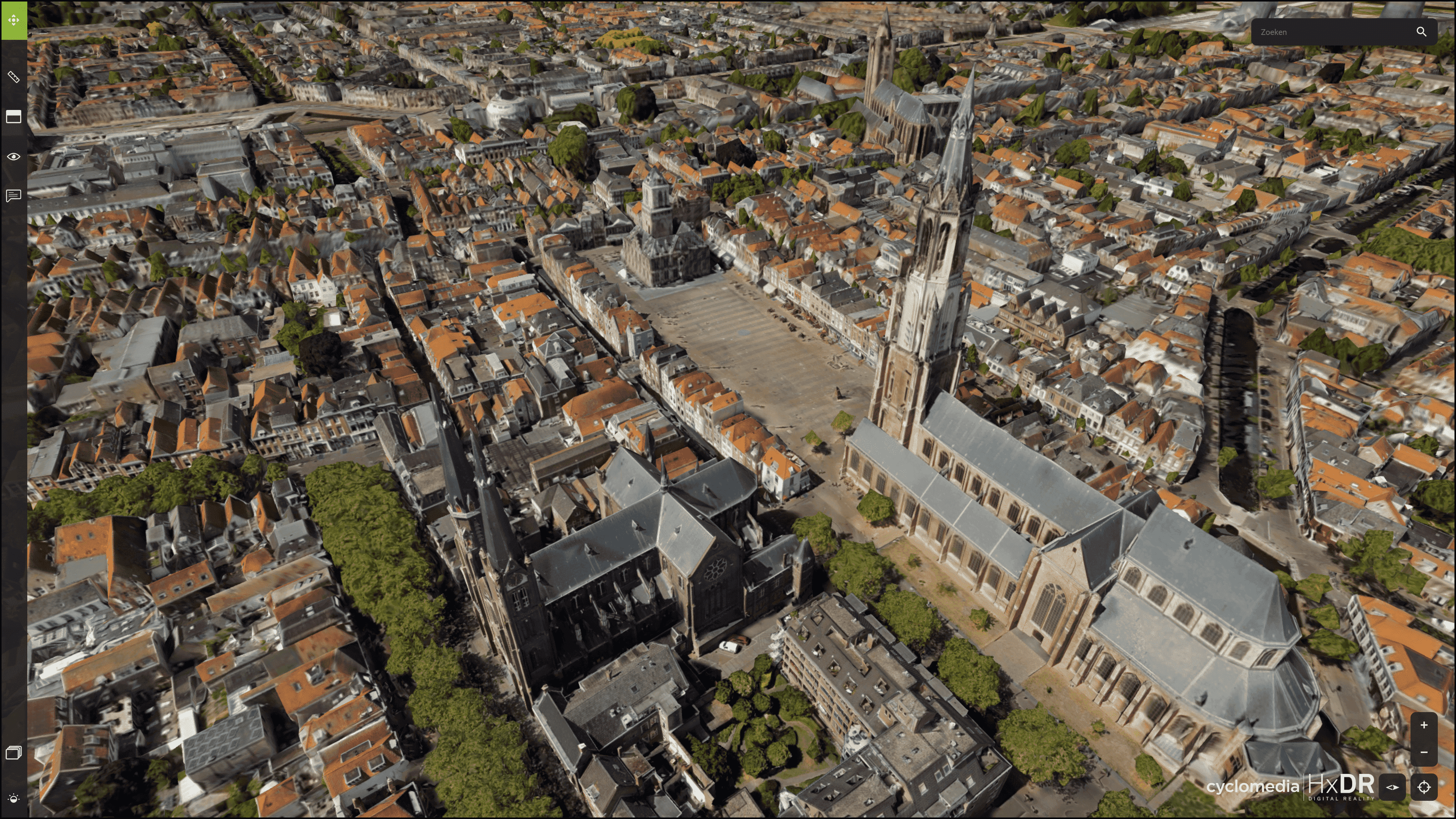
Cyclomedia’s 3DNL, a complete digital twin of the Netherlands, is collected with the Leica CityMapper-2 and hosted on HxDR.

Hexagon provided a wide range of technology that helped Cyclomedia to create 3DNL, the most realistic digital 3D geographic representation of the entire nation. To capture the Netherlands, Cyclomedia partnered with Hexagon to fly the Leica CityMapper-2, the world’s only hybrid oblique imaging and LiDAR airborne sensor. HxDR then enabled the geospatial data and software that built 3DNL to be visualised by users worldwide.

“The partnership with Hexagon enables Cyclomedia to create an innovative 3D data product such as 3DNL,” said Frank Pauli, CEO of Cyclomedia. “Hexagon provides access to the latest technology, including the HxDR cloud-based visualisation platform, hybrid airborne sensor solutions and processing software combined with continuous technical support. Creative business partnerships such as the one we have with Hexagon are the key ingredient to drive innovation in the geospatial industry.”

Geometrically accurate 3D maps and models within 3DNL can be used in many applications enabled by HxDR. Tasks such as importing CAD and BIM data, importing reality capture data, automesh of reality capture data, virtual tours and flythroughs, annotations, and photosphere locations are possible. 3DNL is hosted on HxDR and fully integrated in Street Smart, Cyclomedia’s web viewer.

Features include 3D city mesh measurements (distance, height, volume), asset management, sun and shadow analyses that enable solar capacity calculations and high-rise simulations, and building cross-section analysis. The platform is also ideal for visualising projects for public review and allowing the virtual collaboration of project stakeholders in any field.

“As a technology provider, we strive to offer innovative solutions and business models that meet our customers’ needs,” said John Welter, President, Geospatial Content Solutions at Hexagon. “The collaboration with Cyclomedia showcases how geospatial partnerships can deliver innovative products that serve the public, solve problems and democratise geospatial data. Ultimately, the partnership provides better, faster, and easier access to accurate digital twins of the real world to help professionals do their very best work with the best data.”

Hexagon
Hexagon is a global leader in sensor, software and autonomous solutions. We are putting data to work to boost efficiency, productivity, and quality across industrial, manufacturing, infrastructure, safety, and mobility applications.

Our technologies are shaping urban and production ecosystems to become increasingly connected and autonomous – ensuring a scalable, sustainable future.

Hexagon (Nasdaq Stockholm: HEXA B) has approximately 21,000 employees in 50 countries and net sales of approximately 3.8bn EUR. Learn more at hexagon.com and follow us @HexagonAB.


Related Articles on GISuser:

  • Hexagon Geosystems to showcase smart LiDAR-based 3D Surveillance solution live at ISC West, Las VegasHexagon Geosystems to showcase smart LiDAR-based 3D Surveillance solution live at ISC West, Las Vegas
  • Hexagon Geosystems will exhibit its smart LiDAR-based 3D Surveillance solution live at ISC West.Hexagon Geosystems will exhibit its smart LiDAR-based 3D Surveillance solution live at ISC West.
  • Hexagon’s R-evolution expands its sustainability agenda to help protect coastal blue carbon ecosystemsHexagon’s R-evolution expands its sustainability agenda to help protect coastal blue carbon ecosystems
  • Hexagon’s CEO sells shares — remains committed CEO and shareholderHexagon’s CEO sells shares — remains committed CEO and shareholder
  • HxGN Content Program introduces digital twins of major citiesHxGN Content Program introduces digital twins of major cities
  • Hexagon revolutionises autonomous reality capture with the launch of the Leica BLK ARC and Leica BLK2FLYHexagon revolutionises autonomous reality capture with the launch of the Leica BLK ARC and Leica BLK2FLY

Filed Under: Business, Government & OpenGov Tagged With: Hexagon


Editor’s Picks

Location, Location, Location: Uses for GIS in Health Care

Location, Location, Location: Uses for GIS in Health Care

DigitalGlobe Top Images from 2014 – The fourth annual Top Image contest

Apple Unveils All-New MacBook – The Notebook Reinvented

Have Infographics and Data Visualizations Ruined Good Map Design?

See More Editor's Picks...

About Editor

Glenn is a geographer and a GIS professional with over 20 years experience in the industry. He's the co-founder of GISuser and several other technology web publications.

Feed

  • RSS


GIS jobs


Recent Features

Digitalization and Simulation at the North Pole

Natural Gas District & GIS-Centric Asset Management

5 Ways Technology Is Affecting The Sharing Economy

Spotlight – Township Canada: Explore Canadian Legal Land Descriptions on a Map

GeoGeeksinCars – The one in “Tippy” the right-hand drive Mitsubishi, at DevSummit

More Posts from this Category

Categories

Recent Posts

  • Esri Announces Winners of the 2022 ArcGIS Online Competition
  • KBC WhatsApp Lottery Winner 2022 List – KBC Head Office Number +19188444477 – KBC Sim Card Lucky Draw 2022
  • Animation explainer for a trading application
  • Ordnance Survey supports the British Heart Foundation’s national database of defibrillators
  • Why are AI and Machine Learning Important?

RSS Career Tips

  • Four Characteristics of the Best Virtual Employees
  • 8 Questions Employers Should Ask About Coronavirus
  • Jobcase Launches Free Unemployment Resource Center for Workers Impacted by COVID-19
  • Must-Have Gadgets and Technology for the Remote Office Worker
  • Must-Have Gadgets and Technology for the Remote Office Worker


shop for geogeek swag

RSS Tech pubs

  • Breaking the Code: How Low Code Is Changing Development
  • The Essentials of IT Management - 2022 Kit
  • Achieve a 25-50% reduction in payment postings and charge entry expenses

RSS Computers

  • The Essentials of Information Security Kit: Includes a Free PC Security Handbook - 2nd Edition eBook
  • The Idiot's Ultimate Guide to Build Your Own PC
  • Windows... On Speed

RSS HR Tips

  • At Work: The 2022 Workplace Trends Report
  • The 2022 Guide To Creating A Great Visitor Experience
  • Enterprise Executives Say Hybrid Work is Here to Stay

RSS Gov Tech

  • The Bipartisan Infrastructure Bill: How you can win more bids
  • How Connected Vehicle Data Can Transform Public Sector Decision-Making
  • Getting started with personalization at scale

RSS UAV news

  • Draganfly Deploys Versatile Situational Assessment Drones to Ukraine
  • Ocean Specialists Inc. Launches “USVs as a Service” Business Line
  • UAS Drone Subsidiary, Duke Robotics’, Sniper Drone showcased at a leading International Airshow in the Asia Pacific Region

RSS Geojobs

  • IT Endpoint Lead
Copyright Spatial Media LLC 2003 - 2015