GIS user technology news

News, Business, AI, Technology, IOS, Android, Google, Mobile, GIS, Crypto Currency, Economics

  • Advertising & Sponsored Posts
    • Advertising & Sponsored Posts
    • Submit Press
  • PRESS
    • Submit PR
    • Top Press
    • Business
    • Software
    • Hardware
    • UAV News
    • Mobile Technology
  • FEATURES
    • Around the Web
    • Social Media Features
    • EXPERTS & Guests
    • Tips
    • Infographics
  • Blog
  • Events
  • Shop
  • Tradepubs
  • CAREERS
You are here: Home / * PRESS / Earth Imaging - Remote Sensing / Satellite Imagery @Maxar : Piney Point Phosphate Wastewater Ponds, Florida

Satellite Imagery @Maxar : Piney Point Phosphate Wastewater Ponds, Florida

April 5, 2021 By Editor

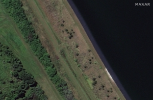
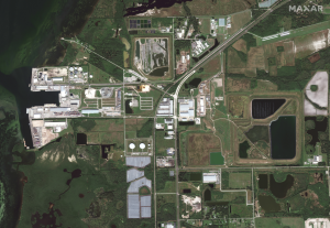
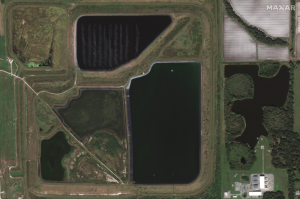
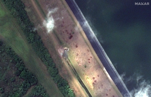
Maxar collected new satellite imagery today, April 5th, that reveals the leak in the retaining wall of a wastewater holding pond in Piney Point, Florida near Tampa Bay. The leak at the reservoir, first discovered last month, is situated next to an abandoned phosphate plant. Emergency crews are removing millions of gallons of water from the reservoir each day to reduce pressure on its liner and avoid a potentially catastrophic flood of the surrounding area. 


©2021 Maxar Technologies

See Also @Maxar on Twitter

Filed Under: Earth Imaging - Remote Sensing, Top Text Lead Story Tagged With: maxar

Editor’s Picks

Unique Hand Drawn Map of London – Ten Years in the Making

Mobile Data Collection with FulcrumApp and Moving into CartoDB

HUD and Zillow Hacking for Affordable housing

CoreLogic Data Reveals Wildfires Pose Big Risk to Nearly 900,000 Western US Homes in 2015

See More Editor's Picks...

About Editor

Glenn is a geographer and a GIS professional with over 20 years experience in the industry. He's the co-founder of GISuser and several other technology web publications.

Recent Industry News

Aerial Surveys Int’l and Global Marketing Insights to Present GEOINT 2026 Workshop on Multi-Domain Geospatial Fusion for Automated Infrastructure Monitoring

April 24, 2026 By GISuser

Why Timing Matters More Than You Think With Spray Seal (And Why People Often Get It Slightly Wrong)

April 22, 2026 By GISuser

The Quiet Planning Stage Most People Don’t See When Building a Pool in Brisbane

April 22, 2026 By GISuser

Best Equipment Labels for Industrial Use: Ranked Systems That Survive Real-World Conditions

April 17, 2026 By GISuser

Hot News

State of Data Science Report – AI and Open Source at Work

HERE and AWS Collaborate on New HERE AI Mapping Solutions

Virtual Surveyor Adds Productivity Tools to Mid-Level Smart Drone Surveying Software Plan

Categories

Copyright gletham Communications 2015 - 2026

Go to mobile version