HEIDELBERG, Germany, March 24, 2021 /PRNewswire/ — NEC Laboratories Europe has prototyped new, AI-enabled drone technology that quickly locates natural disaster victims using their mobile phones or smart devices in areas with damaged or no cellular infrastructure.
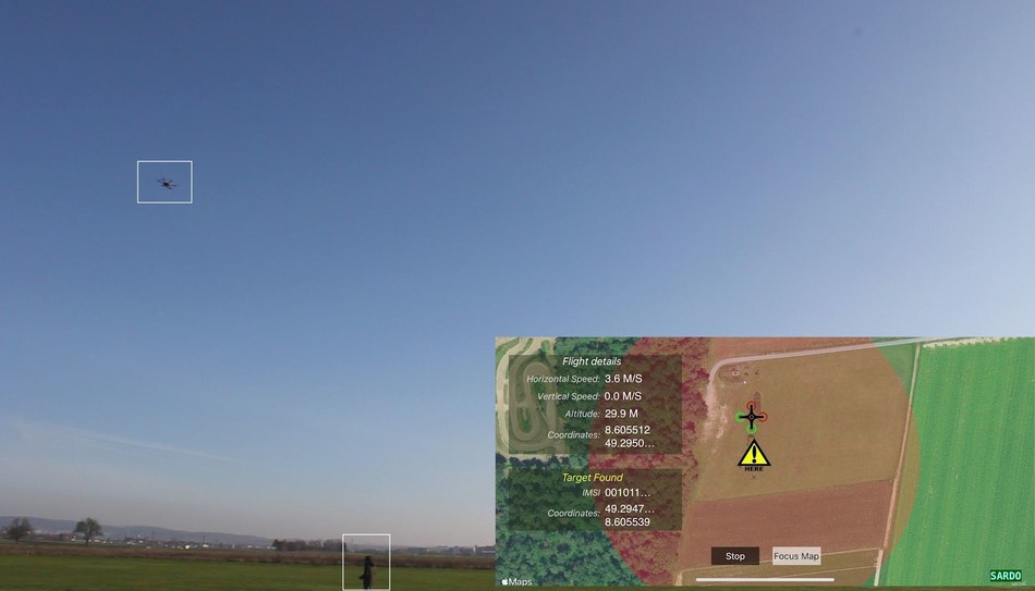
Finding disaster victims is slow and resource intensive. To locate victims, emergency response teams rely on line-of-sight or being in close proximity and mortality rates are often high. NEC’s new prototype technology, SARDO (Search-And-Rescue DrOne), greatly expands search and rescue capabilities by using an autonomous drone as a mobile cellular base station to identify signals from smart devices of victims as it flies nearby.
Existing device tracking technology, such as GPS or standard cellular trilateration, is not suited for natural disaster situations. GPS tracking requires that a disaster victim be in possession of a GPS-enabled smart device and that GPS tracking be active at the time of the disaster. In the event of a natural disaster, such as an earthquake or snow avalanche, cellular network infrastructure may not be working, or the disaster may have occurred in an area with inadequate coverage like a remote, mountainous region. This limits or prevents network operators from locating victims using their mobile phone signals.
SARDO fills this gap by incorporating the functionality of a cellular base station into an autonomous drone. Using pseudo-trilateration SARDO, as a mobile base station, acts as a single anchor that retrieves multiple distance measurements from a disaster victim’s smart device, taken by the drone over its flight time. The SARDO drone uses machine learning to calculate the position of a victim’s device even when that person is moving. The drone continually adjusts itself based on their predicted motion until it has identified the exact position of a victim. Says Antonio Albanese, Research Associate at NEC Laboratories Europe: “SARDO brings together the increasingly higher penetration rate of smart devices in our society and the ability of drones to reach harsh locations. We can now combine these technologies to build a standalone localization system that effectively supports first responders in disaster recovery operations. Requiring no pre-deployment effort, it can be up-and-running within minutes and keep the related deployment complexity to a minimum.”
SARDO works by identifying the unique identification number of a disaster victim’s eSIM or SIM card using the resource control connection that it establishes with a base station. With required emergency approvals, the SARDO drone can search for both a specific victim and all unknown victims within a given region. In collaboration with the network operator, search and rescue teams can also communicate directly with a victim via their devices. In large disasters with many victims, multiple SARDO drones can be used to scale up search and rescue efforts.
In earthquakes, damage to buildings is often extensive and rubble hampers search and rescue efforts. SARDO identifies rubble as a propagation environment and, by compensating for this, can predict a victim’s current location in it. In principle, this same technique is used by SARDO to identify channel artifacts produced by different propagation environments such as snow caused by avalanches or water in times of flooding.
Using commonly available parts, any commercial drone or UAV that meets disaster zone search and rescue requirements can be converted and deployed as a SARDO. This makes it extremely versatile in meeting the needs of different disaster response teams.
1. Economic Losses, Poverty and Disasters: 1998-2017, United Nations Office for Disaster Risk Reduction (UNISDR) & Centre for Research on the Epidemiology of Disasters (CRED)
2. SARDO: An Automated Search-and-Rescue Drone-based Solution for Victims Localization (A. Albanese, V. Sciancalepore, X. Costa-Perez) NEC Laboratories Europe, IEEE Explore, 2021
About NEC Laboratories Europe GmbH
NEC Laboratories Europe located in Heidelberg, Germany was established in 1997 with special emphasis on meeting the needs of NEC Group’s European customers. It dedicates research, development, and standardization on cutting-edge information and communication technologies for creating innovative social solutions. Our major research areas include 5G networks, data science, artificial intelligence, IoT platforms as well as IoT security and blockchain. These technologies will promote NEC Group’s Solutions for a better Society in fields of digital health, lifeline and communication infrastructures, safer cities and public services.
For additional information, please visit our website at: http://www.neclab.eu.
Twitter: @NEC_EMEA
LinkedIn: NEC Laboratories Europe GmbH
NEC is a registered trademark of NEC Corporation. All Rights Reserved. Other product or service marks mentioned herein are the trademarks of their respective owners. ©2021 NEC Corporation.
