GIS user technology news

News, Business, AI, Technology, IOS, Android, Google, Mobile, GIS, Crypto Currency, Economics

  • Advertising & Sponsored Posts
    • Advertising & Sponsored Posts
    • Submit Press
  • PRESS
    • Submit PR
    • Top Press
    • Business
    • Software
    • Hardware
    • UAV News
    • Mobile Technology
  • FEATURES
    • Around the Web
    • Social Media Features
    • EXPERTS & Guests
    • Tips
    • Infographics
  • Blog
  • Events
  • Shop
  • Tradepubs
  • CAREERS
You are here: Home / * PRESS / Business / MAXST officially Launched Spatial AR Platform Technology

MAXST officially Launched Spatial AR Platform Technology

February 9, 2021 By Editor

SEOUL, South Korea, Feb. 9, 2021 /PRNewswire/ — On February 9th 2021, MAXST launched an official website of ‘MAXST VPS’ (vps.maxst.com), a spatial AR platform, MAXST VPS.

‘VPS (Visual Positioning Service) is technology that pinpoints a user’s location by constructing a 3D spatial map for both in/outdoor AR content creations.

MAXST officially launched spatial AR platform technology, MAXST VPS.

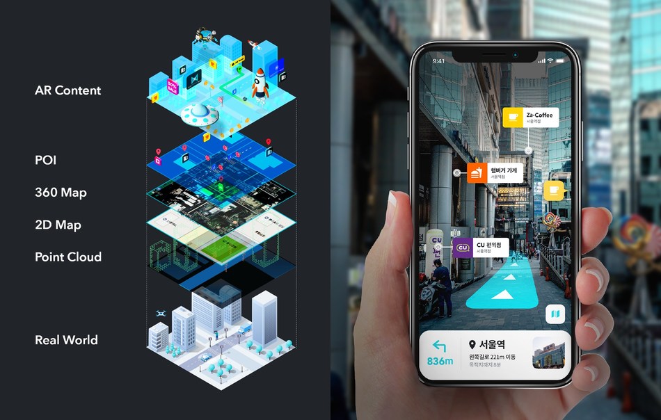
The notion that VPS substitutes GPS is an understatement. GPS technology malfunctions for indoor uses and location errors for outdoor operation, in which it does not provide an exact navigational information of a user.

Not only is VPS technology used for positioning purposes, it also provides various and realistic AR contents such as AR navigation, AR advertisement, and AR games.

The VPS service is going to be provided in the form of a software development kit (SDK) to enable location positioning and AR services for both indoors and outdoors compatible for portable devices such as smartphones, smart glasses, and robots. the SDK is an Unity-based authoring tool and fully operates on Android and iOS.

John Cho, CTO of MAXST states that “MAXST VPS technology will be available for everyone to use, and MAXST will be a medium that connects all aspects of reality to the virtual space in the world of metaverse.”

About MAXST

MAXST helps millions of developers and organizations build and empower convergence of virtually enhanced physical reality with AR (Augmented Reality), AI (Artificial Intelligence) and computer vision technology. As AR Specialist, MAXST provides various solutions and services based on MAXST AR SDK which developed by its own augmented reality technology.

Filed Under: Business Tagged With: AR

Editor’s Picks

Using Lidar to Classify Landslides

Boulder County Launches New Geospatial Open Data Platform

HERE Beta Will Challenge Your Google Maps Loyalty

CoreLogic Data Reveals Wildfires Pose Big Risk to Nearly 900,000 Western US Homes in 2015

See More Editor's Picks...

About Editor

Glenn is a geographer and a GIS professional with over 20 years experience in the industry. He's the co-founder of GISuser and several other technology web publications.

Recent Industry News

The Drift Between Early Notes and Final Case Files in Abuse-Related Legal Support

April 29, 2026 By GISuser

Aerial Surveys Int’l and Global Marketing Insights to Present GEOINT 2026 Workshop on Multi-Domain Geospatial Fusion for Automated Infrastructure Monitoring

April 24, 2026 By GISuser

Why Timing Matters More Than You Think With Spray Seal (And Why People Often Get It Slightly Wrong)

April 22, 2026 By GISuser

The Quiet Planning Stage Most People Don’t See When Building a Pool in Brisbane

April 22, 2026 By GISuser

Hot News

State of Data Science Report – AI and Open Source at Work

HERE and AWS Collaborate on New HERE AI Mapping Solutions

Virtual Surveyor Adds Productivity Tools to Mid-Level Smart Drone Surveying Software Plan

Categories

Copyright gletham Communications 2015 - 2026

Go to mobile version