GIS user technology news

News, Business, AI, Technology, IOS, Android, Google, Mobile, GIS, Crypto Currency, Economics

  • Advertising & Sponsored Posts
    • Advertising & Sponsored Posts
    • Submit Press
  • PRESS
    • Submit PR
    • Top Press
    • Business
    • Software
    • Hardware
    • UAV News
    • Mobile Technology
  • FEATURES
    • Around the Web
    • Social Media Features
    • EXPERTS & Guests
    • Tips
    • Infographics
  • Blog
  • Events
  • Shop
  • Tradepubs
  • CAREERS
You are here: Home / * PRESS / Business / Monitor the World’s Air Pollution – Real Time Air Quality Index Map

Monitor the World’s Air Pollution – Real Time Air Quality Index Map

September 14, 2020 By Editor

With wildfires raging in pretty in the Western regions of the USA, the topic of air quality is on the minds of many, and for very good reason! Air quality in many parts of the western USA and Canada are reporting pollution data readings that are the highest in the World! 


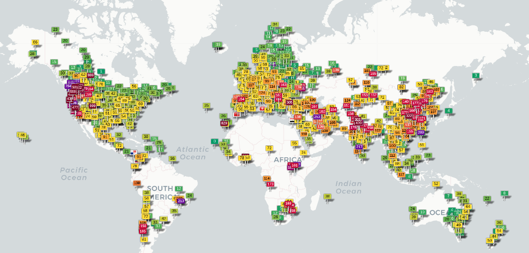
The World’s Air Quality map from https://waqi.info/  shows the real-time air quality for more than 10,000 stations in the world.

About the map – The GAIA air quality monitoring stations are using high-tech laser particle sensors to measure in real-time PM2.5 pollution, which is one of the most harmful air pollutants.

To use the service, simply search for a location or zoom to a specific region on the map. Clicking on a flag icon will then reveal data from the latest reading.


Filed Under: Business, DATA, Earth Imaging - Remote Sensing, Emergency Response, Top Text Lead Story Tagged With: air quality, environment, map, wildfire

Editor’s Picks

HP Inc. Combines Power and Style as it Unleashes World’s First Quad Core Workstation Ultrabook

Dev Tip- The JavaScript Anthology: 101 Essential Tips, Tricks & Hacks

Salary Guide, Tips for Fastest Growing Industries & Top Technology Positions in Demand

Data Tip – Customized Coverage from LandScan Global Population Database

See More Editor's Picks...

About Editor

Glenn is a geographer and a GIS professional with over 20 years experience in the industry. He's the co-founder of GISuser and several other technology web publications.

Recent Industry News

Milwaukee M18FHZ-0 Hackzall Reciprocating Saw – For hardcore cutting in a compact size

June 19, 2026 By GISuser

How Enterprises Are Using AI to Automate 80% of Customer Interactions With Voice Agents

June 16, 2026 By GISuser

Why On Cloud Shoes Are Worth the Price in Mexico

June 16, 2026 By GISuser

Jinghong vs XAG Agricultural Drones: A Comprehensive Comparison Guide

June 16, 2026 By GISuser

Hot News

State of Data Science Report – AI and Open Source at Work

HERE and AWS Collaborate on New HERE AI Mapping Solutions

Virtual Surveyor Adds Productivity Tools to Mid-Level Smart Drone Surveying Software Plan

Categories

Copyright gletham Communications 2015 - 2026

Go to mobile version