GIS user technology news

News, Business, AI, Technology, IOS, Android, Google, Mobile, GIS, Crypto Currency, Economics

  • Advertising & Sponsored Posts
    • Advertising & Sponsored Posts
    • Submit Press
  • PRESS
    • Submit PR
    • Top Press
    • Business
    • Software
    • Hardware
    • UAV News
    • Mobile Technology
  • FEATURES
    • Around the Web
    • Social Media Features
    • EXPERTS & Guests
    • Tips
    • Infographics
  • Blog
  • Events
  • Shop
  • Tradepubs
  • CAREERS
You are here: Home / * PRESS / Environment / Unmanned systems helping fill scientific data gaps during COVID-19

Unmanned systems helping fill scientific data gaps during COVID-19

June 30, 2020 By GISuser

NOAA ramps up use of drones to collect fish, seafloor and weather data
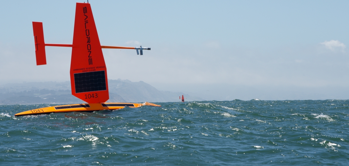
June 19, 2020 –  Three shiny, orange-red autonomous surface vessels set out on the water from Alameda, California, in May bound for the Bering Sea where they will survey the nation’s largest fish stock and monitor changing weather and ocean conditions in the Arctic.

The surface vessels are part of an armada of autonomous (unmanned) ocean vehicles NOAA is deploying this summer in the Pacific, Arctic and Atlantic oceans to provide high-quality environmental data for resource management and weather forecasting.

“We are accelerating the use of unmanned systems during COVID-19 to meet critical mission needs at a time when some of our ship and aircraft missions have been postponed for safety reasons,” said retired Rear Adm. Tim Gallaudet, assistant secretary of commerce for oceans and atmosphere and deputy NOAA administrator. “The innovative systems will provide valuable information for communities at a time when it may be difficult to do so by other means.”

The missions support NOAA’s Unmanned Systems Strategy to advance the use of unmanned systems, which was announced last November at the White House Science & Technology Summit.

Assessing the nation’s largest fishery

In the Bering Sea, the autonomous wind and solar-powered surface vessels will conduct an emergency survey of walleye pollock, our nation’s largest and one of our most valuable domestic fisheries. The surface vessels are expected to provide some key information in time to be used by resource managers to establish fishing levels for the 2021 fishing year.

Equipped with specially designed acoustic sensors, the unmanned vehicles will measure the abundance of pollock. They will also provide information on ocean conditions that affect the pollock population.

Tracking Arctic and Atlantic weather

The same three unmanned surface vessels will also be equipped with sensors to measure wind, solar radiation, salinity and sea surface temperature in the upper ocean, which will be transmitted to the World Meteorological Global Telecommunications System (GTS)offsite link for use by NOAA and other global weather models to predict storms in the Arctic.

In the Atlantic Ocean, Caribbean Sea and Gulf of Mexico, NOAA, IOOS, the U.S. Navy, university and industry partners will deploy for the third year approximately 30 underwater ocean gliders in areas where hurricanes usually travel, to measure ocean temperature and salinity throughout the hurricane season. The data, which help scientists to identify regions where hurricanes may intensify or weaken, will also be transmitted by satellite to the GTS for use in NOAA and global hurricane forecast models. The data are used primarily by researchers to make improvements to forecast models.

This project will also help meet the objectives of the Commercial Engagement Through Ocean Technology Act of 2018, which requires NOAA to coordinate research, assessment,and acquisition of unmanned maritime systems with the U.S. Navy, other federal agencies, industry and academia.

Mapping Alaska’s North Slope

NOAA will also deploy four unmanned surface vesselsoffsite link in the Arctic Ocean equipped with acoustic sensors to map a portion of the seafloor of the Arctic North Slope. This mapping mission will test NOAA’s ability to use the technology to do a more extensive map of the U.S. Arctic seafloor. The project supports the recent Presidential Memorandum on Ocean Mapping in the U.S. Exclusive Economic Zone and Shoreline and Near Shore of Alaska.

Filed Under: Environment, UAV/UAS Tagged With: NOAA

Top Press

The Global Expansion of Aueshah: A New Era of High Jewelry

April 11, 2026 By GISuser

KARACHI, PAKISTAN. The international luxury market is experiencing a profound shift. Consumers are increasingly rejecting mass-produced goods in favor of rarity, authenticity, and emotional depth. … [Read More...]

State of Data Science Report – AI and Open Source at Work

September 10, 2025 By GISuser

AI and Open Source at Work … [Read More...]

Topcon Announces Landmark Expansion of Topnet Live Network Across USA

January 26, 2025 By GISuser

LIVERMORE, Calif.---Topcon Positioning Systems has announced a significant expansion of its Topnet Live reference station network, introducing 200 new geodetic stations strategically positioned across … [Read More...]

Space Flight Laboratory (SFL) Announces Launch and Deployment of NorSat-4 Maritime Monitoring Microsatellite

January 19, 2025 By GISuser

Seventh Satellite Developed by SFL for Norway … [Read More...]

HERE and BMW Group extend partnership on AI-powered mapping system

January 8, 2025 By GISuser

HERE and BMW Group extend partnership on AI-powered mapping system for automated driving and enhanced road safety … [Read More...]

SFL Missions Inc. Confirms Successful Deployment of Six HawkEye 360 Radio Frequency Detection Satellites with Advanced Capabilities

October 27, 2026 By GISuser

MĀHIA, New Zealand, 26 October 2026 – SFL Missions Inc. today confirmed the successful deployment of six radio frequency (RF) detection and geolocation satellites for HawkEye 360 … [Read More...]

Canadian-Built RoadEng 12 Uses AI to Find the Best Location for New Resource and Rural Roads

October 17, 2026 By GISuser

Vancouver, BC, Canada, October 15, 2026 – North Vancouver-based Softree Technical Systems today released RoadEng Version 12, used in more than 75 countries to locate and design … [Read More...]

Beyond the Map: How AI Image and Video Generation Is Changing Geospatial Communication

October 14, 2026 By GISuser

Ask anyone who has shipped a GIS project what the hardest part was, and the answer is rarely the spatial analysis. It is almost always the communication. A site suitability … [Read More...]

From Maternity to Everyday Wear: Building a Wardrobe That Grows With You

October 14, 2026 By GISuser

When I think about maternity clothing, I feel the biggest mistake is buying too many things at once. During pregnancy, your body keeps changing, and something that fits well today … [Read More...]

eMMC 5.1 Explained: Features, Performance, and Applications in Modern Devices

October 14, 2026 By GISuser

Storage technology is an essential part of modern computing, influencing how devices store information, launch applications, and manage everyday workloads. Although … [Read More...]

Copyright gletham Communications 2015 - 2026

Go to mobile version