This updated version of the popular software that allows oil and gas geologists and geophysicists to make better exploration decisions provides a range of new tools and features which further enhance these critical workflows.
Exploration Analyst software for ArcGIS Pro.
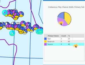
Key to play based exploration (PBE) workflows is understanding how results of previously drilled wells inform the future prospectivity of a petroleum play.
Included in version 2 of Exploration Analyst for ArcGIS Pro is the new Analyse Well Results tool, which allows users to investigate which wells succeeded or failed and to understand why, while identifying underlying spatial relationships.
Another important new feature within version 2 of Exploration Analyst for ArcGIS Pro is the Analyse Prospects tool which delivers important capabilities for prospect portfolio management, including allowing users to summarise prospects by stratigraphic stage, analysing prospect volumes against chance, and assessing play success prospect volume uplift scenarios.
Exprodat COO, Chris Jepps, explains more about the advantages that this latest release will mean for existing and new users; “Exploration Analyst for ArcGIS Pro version 2 provides a more complete toolkit for our customers running PBE workflows in order to identify and rank petroleum exploration targets. The software’s extended well results analysis capabilities build on previous functionality by adding interactive graphical summaries that allow you to spatially interrogate and understand play element success and failure for the plays that you are analysing.”
“Integrated with this, the new prospect analysis capabilities allow you to see your prospect portfolio triaged with geologic time, risk and potential volumes, as well as enabling you to assess how tagging a new play as ‘proven’ will affect the ranking of your prospect portfolio. As well as a host of other new features, Exploration Analyst for ArcGIS Pro is an extremely powerful and user-friendly petroleum exploration extension to Esri’s market-leading desktop GIS technology.”
Exprodat has supported the release of Exploration Analyst for ArcGIS Pro with a blog post on its website that walks prospective users through a selection of the release’s new capabilities