GIS user technology news

News, Business, AI, Technology, IOS, Android, Google, Mobile, GIS, Crypto Currency, Economics

  • Advertising & Sponsored Posts
    • Advertising & Sponsored Posts
    • Submit Press
  • PRESS
    • Submit PR
    • Top Press
    • Business
    • Software
    • Hardware
    • UAV News
    • Mobile Technology
  • FEATURES
    • Around the Web
    • Social Media Features
    • EXPERTS & Guests
    • Tips
    • Infographics
  • Blog
  • Events
  • Shop
  • Tradepubs
  • CAREERS
You are here: Home / * PRESS / Earth Imaging - Remote Sensing / Satellite Imagery: Before/After of Notre Dame Cathedral Fire

Satellite Imagery: Before/After of Notre Dame Cathedral Fire

April 18, 2019 By Editor

On April 17,  Maxar Technologies collected a new WorldView-2 satellite image of the Notre Dame Cathedral in Paris that clearly shows the aftermath of the recent fire.

In this latest imagery, you can see that all of the main roads and bridges that span the Seine River and lead to the cathedral have been cordoned off by police/security. Small crowds of people have also gathered nearby.

Notre Dame Cathedral_Before Fire_17April2019 – Satellite image ©2019 Maxar Technologies.


Notre Dame Cathedral_Before Fire_17April2019

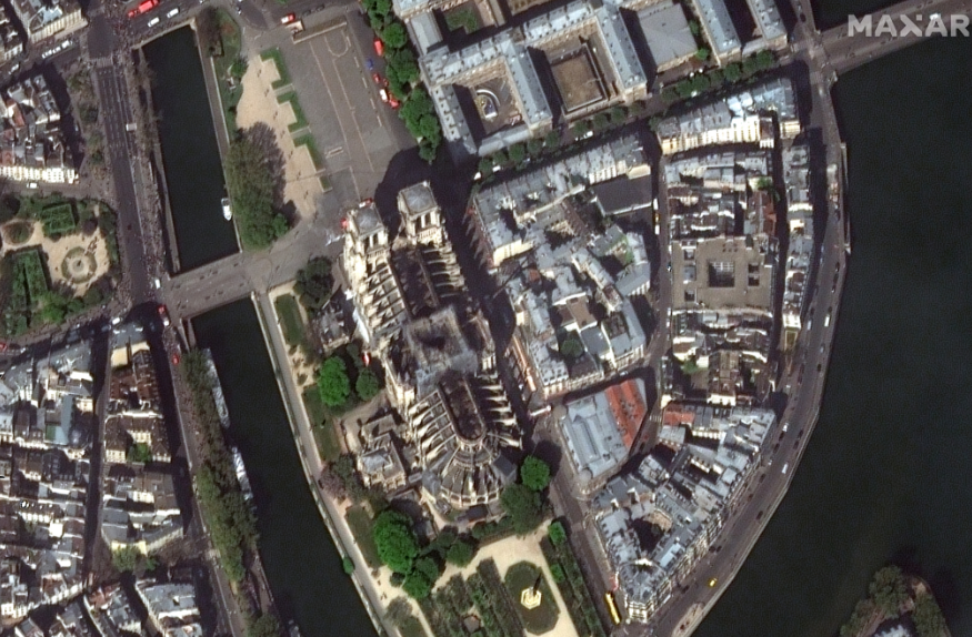
Notre Dame Cathedral_After Fire_17April2019 – Satellite image ©2019 Maxar Technologies.

Filed Under: Earth Imaging - Remote Sensing, Top Press Tagged With: Imagery, notre dame

Editor’s Picks

Feature – How Privacy Concerns Will Shape LiDAR Applications Using UAS

ArcGIS 10.3 and ArcGIS Pro Now Available – Modernize GIS for Organizations and Enterprises

International Conference on Unmanned Aerial Vehicles in Geomatics

HERE Beta Will Challenge Your Google Maps Loyalty

See More Editor's Picks...

About Editor

Glenn is a geographer and a GIS professional with over 20 years experience in the industry. He's the co-founder of GISuser and several other technology web publications.

Recent Industry News

Milwaukee M18FHZ-0 Hackzall Reciprocating Saw – For hardcore cutting in a compact size

June 19, 2026 By GISuser

How Enterprises Are Using AI to Automate 80% of Customer Interactions With Voice Agents

June 16, 2026 By GISuser

Why On Cloud Shoes Are Worth the Price in Mexico

June 16, 2026 By GISuser

Jinghong vs XAG Agricultural Drones: A Comprehensive Comparison Guide

June 16, 2026 By GISuser

Hot News

State of Data Science Report – AI and Open Source at Work

HERE and AWS Collaborate on New HERE AI Mapping Solutions

Virtual Surveyor Adds Productivity Tools to Mid-Level Smart Drone Surveying Software Plan

Categories

Copyright gletham Communications 2015 - 2026

Go to mobile version