Leica Geosystems, GeoPal partner to add high accuracy to mobile operations, drive efficiency, productivity, ensure safety benefits for utility asset collection
(Heerbrugg, Switzerland, 26 July 2018) – Leica Geosystems, part of Hexagon, industry leader in measurement technology, today announced its new partnership with GeoPal to support high accuracy asset data capture for utility professionals within the GeoPal mobile workforce management solution.
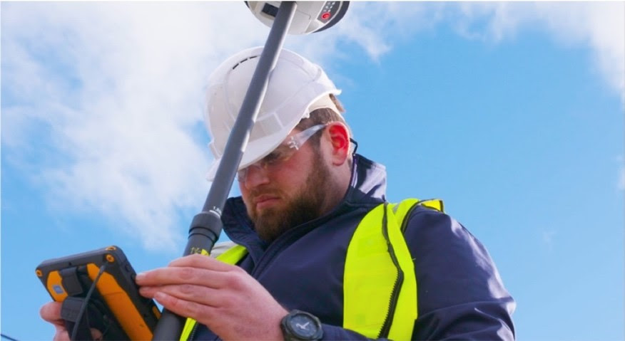
Leica Geosystems and GeoPal have partnered to support high accuracy asset data capture within the GeoPal mobile workforce management solution.
With increased regulatory pressure on utility organisations to provide more accurate location data and asset records, the Leica Zeno GG04 Plus smart antenna is now seamlessly supported by GeoPal to provide high accuracy positions within GeoPal’s Android and iOS mobile applications.
Alan Grady, contracts manager COFFEY GROUP commented; “We utilise the Leica GG04 plus as part of the GeoPal application for our utility construction workflows. The Leica GG04 plus is simple to use and enables the field team to capture the accurate location of assets as they are installed in real time. This enables us to validate jobs for our clients more quickly and ultimately improves the ongoing efficiency and productivity of Coffey group.”
Moving from paper to digital
The Zeno GG04 Plus brings advanced GNSS technology and industry-leading 555 channel tracking power to Geographic Information System (GIS) asset collection. The smart antenna uses RTK technology and applies Precise Point Positioning (PPP). With an open interface, the technology combines with GeoPal for accurate results and efficient operations.
GeoPal has established a wide base of customers across Europe and North America with its consultative implementation process and easy to-use-platform. GeoPal has engineered the core software infrastructure companies need to go from using paper-based forms to complete digital transformation in the field within just a number of weeks.
GeoPal Director and Co-Founder Paul Coyle commented; “The Leica Geosystems smart antenna is easy to use, and we recognised its value as an ideal tool for non-surveying field operatives using GeoPal, who simply need to capture asset locations as part of their job. The GG04 Plus is simple, reliable and provides accurate location data in the demanding work environments GeoPal’s clients work in.”
Leica Geosystems Regional GIS Segment Manager Mike Cooper commented; “We immediately saw the benefits of the GeoPal workflow for organisations looking to improve the quality of their asset records using their own field resources. This is a more efficient way of working; it improves productivity while delivering key safety and financial benefits. It also ensures contractors can quickly validate jobs within the GeoPal application and ensure their clients have access to that information in real time.”
About GeoPal
GeoPal is a customisable mobile workforce management application that connects field workers, remote assets and internet of things sensors, leveraging field data to immediately gain actionable insights and increase the productivity, profitability and health and safety compliance of your business.
GeoPal’s clients include some of the largest Industrial Services, Utility Services, Environmental and Facilities Management companies in the world. They create the core software infrastructure that companies need to mobilise their field-based workforces. GeoPal delivers transformational operational efficiencies through real-time reports and data insights.
Leica Geosystems – when it has to be right
Revolutionising the world of measurement and survey for nearly 200 years, Leica Geosystems, part of Hexagon, creates complete solutions for professionals across the planet. Known for premium products and innovative solution development, professionals in a diverse mix of industries, such as aerospace and defence, safety and security, construction, and manufacturing, trust Leica Geosystems for all their geospatial needs. With precise and accurate instruments, sophisticated software, and trusted services, Leica Geosystems delivers value every day to those shaping the future of our world.
Hexagon is a global leader in digital solutions that create Autonomous Connected Ecosystems (ACE). Hexagon (Nasdaq Stockholm: HEXA B) has approximately 18,000 employees in 50 countries and net sales of approximately 3.5bn EUR. Learn more at hexagon.com and follow us @HexagonAB.