GIS user technology news

News, Business, AI, Technology, IOS, Android, Google, Mobile, GIS, Crypto Currency, Economics

  • Advertising & Sponsored Posts
    • Advertising & Sponsored Posts
    • Submit Press
  • PRESS
    • Submit PR
    • Top Press
    • Business
    • Software
    • Hardware
    • UAV News
    • Mobile Technology
  • FEATURES
    • Around the Web
    • Social Media Features
    • EXPERTS & Guests
    • Tips
    • Infographics
  • Blog
  • Events
  • Shop
  • Tradepubs
  • CAREERS
You are here: Home / * PRESS / Earth Imaging - Remote Sensing / Satellite Imagery: DigitalGlobe Releases High-Resolution Satellite Images of Hurricane Irma Damage

Satellite Imagery: DigitalGlobe Releases High-Resolution Satellite Images of Hurricane Irma Damage

September 11, 2017 By GISuser

As Hurricane Irma churned through the Caribbean and up Florida’s coast, DigitalGlobe’s satellites have been capturing high-resolution images of the storm’s damage. Imaging in the Caribbean became possible over the weekend as the clouds moved out of the area.

Before-and-after imagery taken between Friday, Sept. 8 and Sept. 11 of several places in the Caribbean: Tortola, Turks and Caicos, Sint Maarten, Necker Island, Barbuda and Saint Martin. The “after” images were taken by DigitalGlobe’s WorldView-3, WorldView-2 and GeoEye-1 satellites.

DigitalGlobe has also publicly released pre- and post-event satellite imagery of the areas affected by Hurricane Irma through our Open Data Program, which provides imagery to support recovery efforts in the wake of large-scale natural disasters. Humanitarian OpenStreetMap Team (HOT) set up mapping tasks for Irma using DigitalGlobe imagery in preparation for the storm. Additional tasks will be established once more post-event imagery is available, as will a Tomnodcrowdsourcing campaign.

Port Barbuda - pre Irma

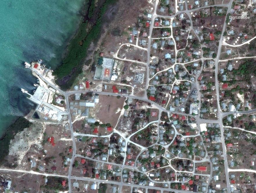
Port Barbuda – pre Irma -satellite image ©2017 DigitalGlobe.


Port Barbuda - post Irma

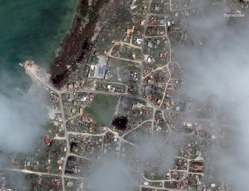
Port Barbuda – post Irma -satellite image ©2017 DigitalGlobe.

St. Maarten, pre Irma

St. Maarten, pre Irma

2017-09-11 16_43_59-Philipsburg_Sint_Maarten_WV2_11SEP2017.jpg _ Powered By BoxSt. Maarten, post Irma

Save

Filed Under: Earth Imaging - Remote Sensing, Emergency Response, Top Text Lead Story Tagged With: DigitalGlobe, hurricane irma

Editor’s Picks

10 Question GeoGeek Rapidfire – Ted Florence @Avenza

Social Guide – The Definitive Starting Point for Mastering your Twitter Analytics

3D Printed Parts for Drones

Panasonic Toughbook 54 Sets New Standard for Semi-Rugged Laptops

See More Editor's Picks...

Recent Industry News

Milwaukee M18FHZ-0 Hackzall Reciprocating Saw – For hardcore cutting in a compact size

June 19, 2026 By GISuser

How Enterprises Are Using AI to Automate 80% of Customer Interactions With Voice Agents

June 16, 2026 By GISuser

Why On Cloud Shoes Are Worth the Price in Mexico

June 16, 2026 By GISuser

Jinghong vs XAG Agricultural Drones: A Comprehensive Comparison Guide

June 16, 2026 By GISuser

Hot News

State of Data Science Report – AI and Open Source at Work

HERE and AWS Collaborate on New HERE AI Mapping Solutions

Virtual Surveyor Adds Productivity Tools to Mid-Level Smart Drone Surveying Software Plan

Categories

Copyright gletham Communications 2015 - 2026

Go to mobile version