GIS user technology news

News, Business, AI, Technology, IOS, Android, Google, Mobile, GIS, Crypto Currency, Economics

  • Advertising & Sponsored Posts
    • Advertising & Sponsored Posts
    • Submit Press
  • PRESS
    • Submit PR
    • Top Press
    • Business
    • Software
    • Hardware
    • UAV News
    • Mobile Technology
  • FEATURES
    • Around the Web
    • Social Media Features
    • EXPERTS & Guests
    • Tips
    • Infographics
  • Blog
  • Events
  • Shop
  • Tradepubs
  • CAREERS
You are here: Home / * PRESS / Earth Imaging - Remote Sensing / DigitalGlobe Releases High-Resolution Satellite Images of Mexico City

DigitalGlobe Releases High-Resolution Satellite Images of Mexico City

September 21, 2017 By Editor

Today DigitalGlobe released high-resolution satellite images that show the damage inflicted by the Sept. 19 earthquake in Mexico City.

Screenshot 2017-09-21 at 8.14.19 PM

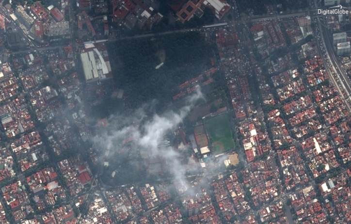
The images show rescue teams at the Enrique Rebsamen School, collapsed buildings near Rancho del Arco and Parque Espana, and an aid distribution area at Parque Espana. The images were taken by DigitalGlobe’s WorldView-2 satellite on Sept. 20.

Separately, DigitalGlobe has publicly released pre- and post-event satellite imagery of areas affected through our Open Data Program, which provides imagery to support recovery efforts in the wake of large-scale natural disasters. Humanitarian OpenStreetMap Team (HOT) tasks have been set up for the Mexico quakes using DigitalGlobe pre-event imagery, and once post-event satellite imagery is available, DigitalGlobe’s Tomnod crowdsourcing team will run a campaign to help with damage assessments. Updates are available on theDigitalGlobe Blog.

Filed Under: Earth Imaging - Remote Sensing Tagged With: DigitalGlobe

Editor’s Picks

How Safe is Google Wallet?

How Safe is Google Wallet?

NASA, NOAA Find 2014 Warmest Year in Modern Record

A Possible Date Conflict with 2016 ESRIUC and the MLB All Star Game

Google recruits a camel as a Trekker to map Street View desert

See More Editor's Picks...

About Editor

Glenn is a geographer and a GIS professional with over 20 years experience in the industry. He's the co-founder of GISuser and several other technology web publications.

Recent Industry News

Milwaukee M18FHZ-0 Hackzall Reciprocating Saw – For hardcore cutting in a compact size

June 19, 2026 By GISuser

How Enterprises Are Using AI to Automate 80% of Customer Interactions With Voice Agents

June 16, 2026 By GISuser

Why On Cloud Shoes Are Worth the Price in Mexico

June 16, 2026 By GISuser

Jinghong vs XAG Agricultural Drones: A Comprehensive Comparison Guide

June 16, 2026 By GISuser

Hot News

State of Data Science Report – AI and Open Source at Work

HERE and AWS Collaborate on New HERE AI Mapping Solutions

Virtual Surveyor Adds Productivity Tools to Mid-Level Smart Drone Surveying Software Plan

Categories

Copyright gletham Communications 2015 - 2026

Go to mobile version