GIS user technology news

News, Business, AI, Technology, IOS, Android, Google, Mobile, GIS, Crypto Currency, Economics

  • Advertising & Sponsored Posts
    • Advertising & Sponsored Posts
    • Submit Press
  • PRESS
    • Submit PR
    • Top Press
    • Business
    • Software
    • Hardware
    • UAV News
    • Mobile Technology
  • FEATURES
    • Around the Web
    • Social Media Features
    • EXPERTS & Guests
    • Tips
    • Infographics
  • Blog
  • Events
  • Shop
  • Tradepubs
  • CAREERS
You are here: Home / * PRESS / Developer / Using ArcGIS Online to Quickly Deploy a Public Information Wildfire Information Map

Using ArcGIS Online to Quickly Deploy a Public Information Wildfire Information Map

July 18, 2017 By GISuser

In interesting story from BC, Canada where a Geotech developer, who happened to work for an Esri startup program member company, had a need to quickly mashup a resource to help inform the public about wildfire dangers and resources to inform and help keep citizens safe and out of harms way.

Public Information Wildfire Information Map

This via the MapThis blog…

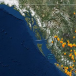
The story of the map comes from the recent flare up of wildfires in the Interior of British Columbia. Wind and weather conditions have made battling the flames difficult and the public has been faced with road closures, making it even more difficult to plot an escape strategy.

Enter Neil Johnston (@NeilJohnston), Director of product design from Echosec. Neil turned to online sources and public data feeds etc… provided by various government agencies in order to determine a strategy for his parents to get out of harms way. Johnson realized quickly that he was faced with dealing with a mish-mash of data feeds and products from various agencies, resulting a puzzle that he needed to piece together. Naturally, he thought that he could put his skills to use and create a public facing map that would help others in the same situation.

Neil had the knowledge and technology available to create the product. Initially he turned to google and quickly built a map of feeds. He then turned to his company, Echosec, for support and they ported the map/app to the ArcGIS Online environment in order to create a public map service that was reliable and most important, mobile friendly.

Continue reading how the team deployed the resource to ArcGIS Online and resolved a much needed problem for the public


See BC Firemap Plus

Read more updates about Echosec

See Also:

B.C, Canada Wildfires Map, 2016 – How many fires are started by humans?

B.C, Canada Wildfires Map, 2016 – How many fires are started by humans?

Save

Save

Filed Under: Developer, Emergency Response, Top Press Tagged With: bc, echosec, wildfire

Editor’s Picks

Event Review, Commercial Drone Expo

47th Annual Magnet States Report — Where Did America Move in 2014?

Leica RCD30: Better Resolution with More Details for 3D City Modeling

Geospago and what3words partner to provide a mobile mapping solution with 3-word addressing throughout the globe

See More Editor's Picks...

Recent Industry News

Milwaukee M18FHZ-0 Hackzall Reciprocating Saw – For hardcore cutting in a compact size

June 19, 2026 By GISuser

How Enterprises Are Using AI to Automate 80% of Customer Interactions With Voice Agents

June 16, 2026 By GISuser

Why On Cloud Shoes Are Worth the Price in Mexico

June 16, 2026 By GISuser

Jinghong vs XAG Agricultural Drones: A Comprehensive Comparison Guide

June 16, 2026 By GISuser

Hot News

State of Data Science Report – AI and Open Source at Work

HERE and AWS Collaborate on New HERE AI Mapping Solutions

Virtual Surveyor Adds Productivity Tools to Mid-Level Smart Drone Surveying Software Plan

Categories

Copyright gletham Communications 2015 - 2026

Go to mobile version