GISuser.com

GIS and Technology news for mapping professionals

  • PRESS
    • Submit PR
    • Top Press
    • Business
    • Software
    • Hardware
    • UAV News
    • Mobile Technology
  • FEATURES
    • Around the Web
    • Social Media Features
    • EXPERTS & Guests
    • Tips
    • Infographics
  • Events
  • CAREERS
  • Advertise
    • Advertise
  • Blog
  • Shop
  • Tradepubs
You are here: Home / * PRESS / Earth Imaging - Remote Sensing / First High-Resolution Image Released from Harris Corporation-Built Imaging System Onboard DigitalGlobe’s WorldView-4 Satellite

First High-Resolution Image Released from Harris Corporation-Built Imaging System Onboard DigitalGlobe’s WorldView-4 Satellite

December 2, 2016 By GISuser

DigitalGlobe, Inc (NYSE: DGI) has released the initial image from the Harris Corporation (NYSE:HRS) high-resolution, multi-spectral imaging system, which is onboard the Lockheed Martin-built WorldView-4 commercial Earth imaging satellite. The first image, captured on November 26, shows the Yoyogi National Gymnasium in Shibuya, Tokyo, and can be viewed and downloaded on the WorldView-4 microsite.

Image Credit: Digitalglobe, Harris

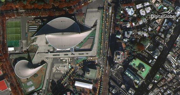
Image Credit: DigitalGlobe, Harris

Highlights:

  • Imaging system captures multi-spectral imagery from 617 kilometers above the Earth
  • Harris-built system/sensors are on all DigitalGlobe satellites ever flown
  • Payload enables rapid collection of many scenarios, shortening response times to global events

Orbiting at 617 kilometers above the earth and traveling 17,000 miles per hour, WorldView-4 more than doubles DigitalGlobe’s capacity to collect the world’s highest-resolution, 30 cm commercial satellite imagery — capturing as much as 680,000 square kilometers of the Earth’s surface per day.

“Harris’ innovative imaging systems enable DigitalGlobe to do more than capture spectacular images. They also enhance global transparency by providing valuable insights, context and information on important events around the world,” said Rob Mitrevski, vice president and general manager, Harris Intelligence, Surveillance and Reconnaissance business.

“Harris has been making world-class Earth imaging instruments for DigitalGlobe since our launch of the world’s first high-resolution commercial imaging satellite, IKONOS, in 1999,” said Dr. Walter Scott, DigitalGlobe founder, EVP, and CTO. “Harris’ large-aperture telescopes allow our satellites to image vast areas of the Earth very quickly, which combined with the agility of our satellite platforms, ensure that the right image is captured when time is of the essence. And the enormous amount of information contained in each image allows our customers to make critical decisions with confidence.”

About Harris Corporation
Harris Corporation is a leading technology innovator, solving customers’ toughest mission-critical challenges by providing solutions that connect, inform and protect. Harris supports customers in more than 100 countries and has approximately $7.5 billion in annual revenue and 21,000 employees worldwide. The company is organized into four business segments: Communication Systems, Space and Intelligence Systems, Electronic Systems and Critical Networks. Learn more at harris.com.

Related Articles on GISuser:

  • DigitalGlobe Shares Satellite Imagery of California SuperbloomDigitalGlobe Shares Satellite Imagery of California Superbloom
  • DigitalGlobe Satellite Imagery: Flooding in U.S. MidwestDigitalGlobe Satellite Imagery: Flooding in U.S. Midwest
  • Satellite Imagery: Hurricane Michael Aftermath in Panama City and Tyndall AFBSatellite Imagery: Hurricane Michael Aftermath in Panama City and Tyndall AFB
  • DigitalGlobe Satellite Reveals Imagery of Russian Military Exercise (Vostok 2018)DigitalGlobe Satellite Reveals Imagery of Russian Military Exercise (Vostok 2018)
  • Maxar Technologies’ DigitalGlobe Expands Agreements with Two Major Commercial Technology CustomersMaxar Technologies’ DigitalGlobe Expands Agreements with Two Major Commercial Technology Customers
  • DigitalGlobe Releases High-Resolution Satellite Images of the Northern California WildfiresDigitalGlobe Releases High-Resolution Satellite Images of the Northern California Wildfires

Filed Under: Earth Imaging - Remote Sensing Tagged With: DigitalGlobe, HArris, WorldView-4 Satellite


Editor’s Picks

Career Tips – Common Career Paths for the Student of GIS, an Infographic from USC

CoreLogic Data Reveals Wildfires Pose Big Risk to Nearly 900,000 Western US Homes in 2015

Mapping Reform: Where are Things Likely to Change?

Geospago and what3words partner to provide a mobile mapping solution with 3-word addressing throughout the globe

See More Editor's Picks...

Feed

  • RSS


GIS jobs


Recent Features

Digitalization and Simulation at the North Pole

Natural Gas District & GIS-Centric Asset Management

5 Ways Technology Is Affecting The Sharing Economy

Spotlight – Township Canada: Explore Canadian Legal Land Descriptions on a Map

GeoGeeksinCars – The one in “Tippy” the right-hand drive Mitsubishi, at DevSummit

More Posts from this Category

Categories

Recent Posts

  • NOAA predicts above-normal 2022 Atlantic Hurricane Season
  • Space logistics markets ready to grow as on-orbit supplier services materialize
  • Applications Invited for URISA’s Vanguard Cabinet
  • The Rise of Ryoshis Vision ($RYOSHI) as It Takes a Revolutionary Approach to the Crypto Market
  • Tips for Working on a Computer All Day

RSS Career Tips

  • Four Characteristics of the Best Virtual Employees
  • 8 Questions Employers Should Ask About Coronavirus
  • Jobcase Launches Free Unemployment Resource Center for Workers Impacted by COVID-19
  • Must-Have Gadgets and Technology for the Remote Office Worker
  • Must-Have Gadgets and Technology for the Remote Office Worker


shop for geogeek swag

RSS Tech pubs

  • Recruiting Metrics for the Modern Recruiter
  • Metrics for the Modern Recruiter
  • Learn to Optimize High-Volume Recruitment Planning

RSS Computers

  • HackerProof: Your Guide to PC Security
  • Windows... On Speed
  • The Idiot's Ultimate Guide to Build Your Own PC

RSS HR Tips

  • Learn to Optimize High-Volume Recruitment Planning
  • 2022 Restaurant & Retail Talent Acquisition Predictions Report
  • Talroo's 2022 Complete Restaurant Hiring Playbook

RSS Gov Tech

  • Flexibility, Work-Life Balance, and Job Satisfaction: Why More Lawyers Are Seeking Career Alternatives
  • Clio: Guide to Law Office Automation
  • The 11 Habits of Highly Successful Law Firms

RSS UAV news

  • UAS Drone Subsidiary, Duke Robotics’, Sniper Drone showcased at a leading International Airshow in the Asia Pacific Region
  • Short Battery Life: A Drone’s Worst Enemy
  • UMAV ANNOUNCES ITS LIGHTER THAN AIR DETACHABLE DRONE IS COMPLETING FINAL AVIONICS INSTALLATION

RSS Geojobs

  • Help Desk Technician
Copyright Spatial Media LLC 2003 - 2015