GIS user technology news

News, Business, AI, Technology, IOS, Android, Google, Mobile, GIS, Crypto Currency, Economics

  • Advertising & Sponsored Posts
    • Advertising & Sponsored Posts
    • Submit Press
  • PRESS
    • Submit PR
    • Top Press
    • Business
    • Software
    • Hardware
    • UAV News
    • Mobile Technology
  • FEATURES
    • Around the Web
    • Social Media Features
    • EXPERTS & Guests
    • Tips
    • Infographics
  • Blog
  • Events
  • Shop
  • Tradepubs
  • CAREERS
You are here: Home / * PRESS / Software / SuperGIS Server 3.3 Is Now Released

SuperGIS Server 3.3 Is Now Released

September 28, 2016 By GISuser

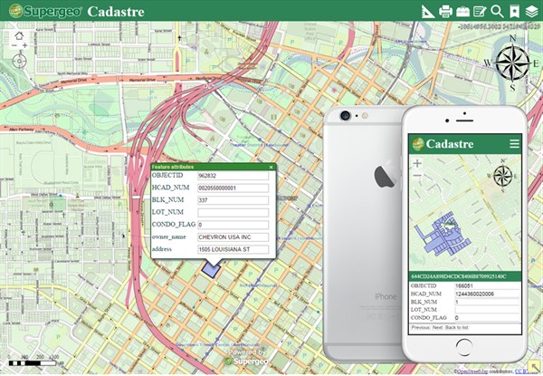
SuperGIS Server 3.3.0001, the latest version of SuperGIS Server is now released! In this version, the most distinguishable feature will be the new ultra application, which has not only a more user-friendly interface design but also a mobile layout that allows users to interact with the map on mobile devices. Also, SuperGIS Server 3.3 is fully compatible with Windows Server 2012 and IIS 8, so users can set up the GIS server with latest Microsoft technologies. 

In the future versions, the workflow of SuperGIS Server will be further improved to let users get their hands-on much easier. For example, if you need to deploy multiple servers for a web application with many visitors, the new design and settings will make you easier to duplicate the environment and enjoy the powerful server GIS technology.

In conclusion, SuperGIS Server 3.3 is designed to enhance the interactivity on both PC and mobile devices. Users will definitely find it more intuitive to interact with the web application. In addition to the front-end side, the workflow on the server side will also be improved for providing a better user experience.


Understand how to use mobile devices to access cadastral data:
https://www.youtube.com/watch?v=RdBmwOdgjT4

Contact us to get the free license of SuperGIS Server 3.3:
staff@supergeotek.com.tw
Filed Under: Software Tagged With: SuperGIS Server

Editor’s Picks

GIS and History: Using the Past to Inform the Present

Trimble Obtains Exemption to Operate its Unmanned Aircraft System

Trimble Unity – Next Generation Suite of Software Applications for Water, Wastewater and Stormwater Utilities

Data Tip – Customized Coverage from LandScan Global Population Database

See More Editor's Picks...

Recent Industry News

Why Bathroom Renovation Services Often Change More Than Just the Bathroom

May 20, 2026 By GISuser

The Drift Between Early Notes and Final Case Files in Abuse-Related Legal Support

April 29, 2026 By GISuser

Aerial Surveys Int’l and Global Marketing Insights to Present GEOINT 2026 Workshop on Multi-Domain Geospatial Fusion for Automated Infrastructure Monitoring

April 24, 2026 By GISuser

Why Timing Matters More Than You Think With Spray Seal (And Why People Often Get It Slightly Wrong)

April 22, 2026 By GISuser

Hot News

State of Data Science Report – AI and Open Source at Work

HERE and AWS Collaborate on New HERE AI Mapping Solutions

Virtual Surveyor Adds Productivity Tools to Mid-Level Smart Drone Surveying Software Plan

Categories

Copyright gletham Communications 2015 - 2026

Go to mobile version