Things are heating up, there’s no doubt about that. In fact, according to statistics, 2015 was the warmest year ever on record! This from the New York Times, “It will take a few more years to know for certain, but the back-to-back records of 2014 and 2015 may have put the world back onto a trajectory of rapid global warming, after a period of relatively slow warming dating to the last powerful El Niño, in 1998.”
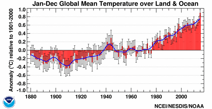
 Source: NOAA, Global Summary information 2015
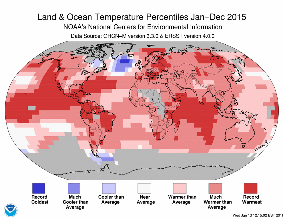
Some of the Global highlights shared by NOAA:
- During 2015, the average temperature across global land and ocean surfaces was 1.62°F (0.90°C) above the 20th century average. This was the highest among all 136 years in the 1880–2015 record, surpassing the previous record set last year by 0.29°F (0.16°C) and marking the fourth time a global temperature record has been set this century. This is also the largest margin by which the annual global temperature record has been broken. Ten months had record high temperatures for their respective months during the year. The five highest monthly departures from average for any month on record all occurred during 2015.
- Record warmth was broadly spread around the world, including Central America, the northern half of South America, parts of northern, southern, and eastern Europe stretching into western Asia, a large section of east central Siberia, regions of eastern and southern Africa, large parts of the northeastern and equatorial Pacific, a large swath of the western North Atlantic, most of the Indian Ocean, and parts of the Arctic Ocean.
- During 2015, the globally-averaged land surface temperature was 2.39°F (1.33°C) above the 20thcentury average. This was the highest among all years in the 1880–2015 record, surpassing the previous record of 2007 by 0.45°F (0.25°C). This is the largest margin by which the annual global land temperature has been broken.
- During 2015, the globally-averaged sea surface temperature was 1.33°F (0.74°C) above the 20thcentury average. This was the highest among all years in the 1880–2015 record, surpassing the previous record of last year by 0.20°F (0.11°C).
For extended analysis of global climate patterns, please see this full Annual report from NOAA