GIS user technology news

News, Business, AI, Technology, IOS, Android, Google, Mobile, GIS, Crypto Currency, Economics

  • Advertising & Sponsored Posts
    • Advertising & Sponsored Posts
    • Submit Press
  • PRESS
    • Submit PR
    • Top Press
    • Business
    • Software
    • Hardware
    • UAV News
    • Mobile Technology
  • FEATURES
    • Around the Web
    • Social Media Features
    • EXPERTS & Guests
    • Tips
    • Infographics
  • Blog
  • Events
  • Shop
  • Tradepubs
  • CAREERS
You are here: Home / * PRESS / acquisitions and funding / Garmin completes acquisition of DeLorme

Garmin completes acquisition of DeLorme

March 3, 2016 By GISuser

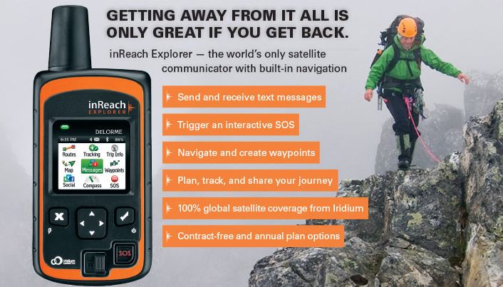
SCHAFFHAUSEN, Switzerland & YARMOUTH, Maine–Garmin Ltd. (NASDAQ: GRMN), announced today that it has completed the acquisition of DeLorme, a privately-held company that designs and markets consumer-based satellite tracking devices with two-way communication and navigational capabilities.
Garmin completes acquisition of DeLorme

“We are looking forward to leveraging the outstanding expertise and skills of the DeLorme team to enable the development of innovative products that will enhance the lives of our customers.”

“We are pleased to have the DeLorme team join the Garmin family,” said Cliff Pemble, president and CEO of Garmin. “We are looking forward to leveraging the outstanding expertise and skills of the DeLorme team to enable the development of innovative products that will enhance the lives of our customers.”

DeLorme pioneered the inReach series of affordable two-way satellite communication devices for the consumer market. These GPS-enabled devices allow the user to send and receive satellite text messages or trigger an SOS for emergency help, anywhere in the world. In addition to inReach, DeLorme has an extensive library of digital cartography and enterprise GIS software, as well as traditional mapping.

Garmin will retain most of the DeLorme associates and will continue operations at its existing location in Yarmouth, Maine. The facility will operate primarily as a research and development office and the team will continue to develop two-way satellite communication and cartographic solutions. Financial terms of the transaction were not released.

About Garmin Ltd.

Garmin Ltd. is incorporated in Schaffhausen, Switzerland, and its principal subsidiaries are located in the United States, Taiwan and the United Kingdom. Garmin is a registered trademark of Garmin Ltd. or its subsidiaries.

Notice on Forward-Looking Statements:

This release includes forward-looking statements regarding Garmin Ltd. and its business. Such statements are based on management’s current expectations. The forward-looking events and circumstances discussed in this release may not occur and actual results could differ materially as a result of known and unknown risk factors and uncertainties affecting Garmin, including, but not limited to, the risk factors listed in the Annual Report on Form 10-K for the year ended December 26, 2015, filed by Garmin with the Securities and Exchange Commission (Commission file number 0-31983). A copy of such Form 10-K is available at http://www.garmin.com/aboutGarmin/invRelations/finReports.html. No forward-looking statement can be guaranteed. Forward-looking statements speak only as of the date on which they are made and Garmin undertakes no obligation to publicly update or revise any forward-looking statement, whether as a result of new information, future events, or otherwise.

Filed Under: acquisitions and funding Tagged With: Delorme, Garmin

Top Press

The Global Expansion of Aueshah: A New Era of High Jewelry

April 11, 2026 By GISuser

KARACHI, PAKISTAN. The international luxury market is experiencing a profound shift. Consumers are increasingly rejecting mass-produced goods in favor of rarity, authenticity, and emotional depth. … [Read More...]

State of Data Science Report – AI and Open Source at Work

September 10, 2025 By GISuser

AI and Open Source at Work … [Read More...]

Topcon Announces Landmark Expansion of Topnet Live Network Across USA

January 26, 2025 By GISuser

LIVERMORE, Calif.---Topcon Positioning Systems has announced a significant expansion of its Topnet Live reference station network, introducing 200 new geodetic stations strategically positioned across … [Read More...]

Space Flight Laboratory (SFL) Announces Launch and Deployment of NorSat-4 Maritime Monitoring Microsatellite

January 19, 2025 By GISuser

Seventh Satellite Developed by SFL for Norway … [Read More...]

HERE and BMW Group extend partnership on AI-powered mapping system

January 8, 2025 By GISuser

HERE and BMW Group extend partnership on AI-powered mapping system for automated driving and enhanced road safety … [Read More...]

Beyond the Map: How AI Image and Video Generation Is Changing Geospatial Communication

October 14, 2026 By GISuser

Ask anyone who has shipped a GIS project what the hardest part was, and the answer is rarely the spatial analysis. It is almost always the communication. A site suitability … [Read More...]

From Maternity to Everyday Wear: Building a Wardrobe That Grows With You

October 14, 2026 By GISuser

When I think about maternity clothing, I feel the biggest mistake is buying too many things at once. During pregnancy, your body keeps changing, and something that fits well today … [Read More...]

eMMC 5.1 Explained: Features, Performance, and Applications in Modern Devices

October 14, 2026 By GISuser

Storage technology is an essential part of modern computing, influencing how devices store information, launch applications, and manage everyday workloads. Although … [Read More...]

SFL Missions Inc. Confirms Successful Deployment of Two GHGSat Greenhouse Gas Monitoring Microsatellites

October 3, 2026 By GISuser

TORONTO, Ontario, Canada, 2 October 2026 – SFL Missions Inc. confirms the successful launch and deployment of the GHGSat-C18 (Eleanor) and GHGSat-C19 (Aidan) commercial greenhouse … [Read More...]

GIS Cloud user growth doubles as AI-powered geospatial intelligence outpaces specialist capacity

September 29, 2026 By GISuser

More than 100 new users join the platform every day, driven by demand for AI-powered geospatial intelligence  Asterra, Pipe View America and InfraTrace among organisations to … [Read More...]

Copyright gletham Communications 2015 - 2026

Go to mobile version