GIS user technology news

News, Business, AI, Technology, IOS, Android, Google, Mobile, GIS, Crypto Currency, Economics

  • Advertising & Sponsored Posts
    • Advertising & Sponsored Posts
    • Submit Press
  • PRESS
    • Submit PR
    • Top Press
    • Business
    • Software
    • Hardware
    • UAV News
    • Mobile Technology
  • FEATURES
    • Around the Web
    • Social Media Features
    • EXPERTS & Guests
    • Tips
    • Infographics
  • Blog
  • Events
  • Shop
  • Tradepubs
  • CAREERS
You are here: Home / * PRESS / Software / Maptitude 2016 is Available Now

Maptitude 2016 is Available Now

February 9, 2016 By Editor

NEWTON, MA (USA) – Caliper Corporation is pleased to announce that Maptitude 2016, a major release of Caliper Corporation’s popular GIS (Geographic Information System) and mapping software, is available now. The 2016 version provides the most up-to-date and accurate data available.
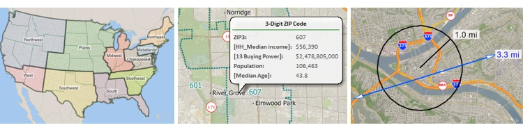
Maptitude 2016

New territory management tools

Businesses require robust territory creation tools that excel in both the handling of data tables and in the visual manipulation and representation of service areas. Maptitude 2016 was designed to exceed these requirements and provides an intuitive Territory Wizard and a sophisticated Territory Manager with complete undo and redo support.

“It is simply amazing to see Maptitude progress. In Maptitude 2016 the Routing Manager and Territory Manager are extremely useful and user friendly. The added functionality, updated interface, and the speed of calculations are exactly what I need to perform my work as a logistics consultant.”
Paul Lucassen
Lucassen Consulting

Support for MapPoint-like tools & queries

Maptitude now dominates the space vacated by Microsoft MapPoint. Maptitude ships with the latest maps, data, and demographics. With enhanced versions of the features that Microsoft MapPoint users are familiar with, Maptitude retains the ease-of-use of the MapPoint tools while providing the functionality that Microsoft users could only wish for.


The new and improved tools include:

  • Territory management and import
  • Route/directions management
  • A hover label tool
  • A circle/radius drawing tool and a line drawing tool, each auto-labeled with distance
  • Support for metropolitan areas and 3-digit ZIP Code areas
  • MapPoint, Streets & Trips, and AutoRoute file format support

Updated road networks and travel speeds

New U.S. data sets provide access to the most up-to-date geographic information available. Maptitude now includes 4th Quarter 2015 map content that allows for accurate address locating and street visualization, as well as robust data on which to calculate shortest paths, drive-time rings, and drive-time territories. Accurate, comprehensive, average traffic speed data are now included.

Faster distance and travel time calculations

Speed improvements provide faster access to maps, routes, drive-time rings, and geographic analysis. Maptitude 2016 provides significant speedups in map display with faster drawing of styles, filters, layers, and labels.

Improved drive time areas

The Drive Time Rings Toolbox improves your ability to create the most accurate drive-time travel analysis on the market with the following enhancements to the tool:

  • Updated shortest path calculations
  • Improved speed and efficiency while using less memory
  • Redesigned interface with cumulative bands, separate origins, and driving speed adjustments

The latest demographics

The US Census boundaries (e.g., Tracts, Counties, MCDs, MSAs, States) and the 3- and 5-digit ZIP code areas that come with Maptitude contain some or all of several demographic profiles from a variety of data providers. These sources include the 2010 Census and the 2014 ACS Census to name a few. These data are available for the USA, Puerto Rico, and the Territories. The ZIP Code, Tract, County, and State layers also include updated buying power (disposable income) figures. Tracts also list updated banking compliance FFIEC data for 2015. The Map Librarian makes it easy to access a series of pre-defined thematic and shaded maps of these data.

Buy Maptitude 2016 NowPlease contact the Maptitude Sales Team with any questions. View our new Maptitude 2016 videos here.

About Caliper

Caliper Corporation develops state-of-the-art Geographic Information Systems (GIS) software. With a focus on usability, Maptitude is designed to be a cost-effective, professional mapping software product. Maptitude enables organizations to leverage their location-based data to improve decision making and planning, while minimizing expenditure through competitively priced solutions.

Caliper is a privately held corporation and is a leading developer of mapping, redistricting, transportation, and GIS software.

Filed Under: Software Tagged With: caliper, Maptitude

About Editor

Glenn is a geographer and a GIS professional with over 20 years experience in the industry. He's the co-founder of GISuser and several other technology web publications.

Top Press

The Global Expansion of Aueshah: A New Era of High Jewelry

April 11, 2026 By GISuser

KARACHI, PAKISTAN. The international luxury market is experiencing a profound shift. Consumers are increasingly rejecting mass-produced goods in favor of rarity, authenticity, and emotional depth. … [Read More...]

State of Data Science Report – AI and Open Source at Work

September 10, 2025 By GISuser

AI and Open Source at Work … [Read More...]

Topcon Announces Landmark Expansion of Topnet Live Network Across USA

January 26, 2025 By GISuser

LIVERMORE, Calif.---Topcon Positioning Systems has announced a significant expansion of its Topnet Live reference station network, introducing 200 new geodetic stations strategically positioned across … [Read More...]

Space Flight Laboratory (SFL) Announces Launch and Deployment of NorSat-4 Maritime Monitoring Microsatellite

January 19, 2025 By GISuser

Seventh Satellite Developed by SFL for Norway … [Read More...]

HERE and BMW Group extend partnership on AI-powered mapping system

January 8, 2025 By GISuser

HERE and BMW Group extend partnership on AI-powered mapping system for automated driving and enhanced road safety … [Read More...]

Everest Base Camp Helicopter Tour, Helicopter Return Trek, and Manaslu Circuit Trek: Which Nepal Adventure Is Right for You?

November 6, 2026 By GISuser

Almost everyone planning a Nepal trip runs into the same wall. You want the big mountains, you have a fixed number of days, and every itinerary you read seems to promise something … [Read More...]

SFL Missions Inc. Confirms Successful Deployment of Six HawkEye 360 Radio Frequency Detection Satellites with Advanced Capabilities

October 27, 2026 By GISuser

MĀHIA, New Zealand, 26 October 2026 – SFL Missions Inc. today confirmed the successful deployment of six radio frequency (RF) detection and geolocation satellites for HawkEye 360 … [Read More...]

Canadian-Built RoadEng 12 Uses AI to Find the Best Location for New Resource and Rural Roads

October 17, 2026 By GISuser

Vancouver, BC, Canada, October 15, 2026 – North Vancouver-based Softree Technical Systems today released RoadEng Version 12, used in more than 75 countries to locate and design … [Read More...]

Beyond the Map: How AI Image and Video Generation Is Changing Geospatial Communication

October 14, 2026 By GISuser

Ask anyone who has shipped a GIS project what the hardest part was, and the answer is rarely the spatial analysis. It is almost always the communication. A site suitability … [Read More...]

From Maternity to Everyday Wear: Building a Wardrobe That Grows With You

October 14, 2026 By GISuser

When I think about maternity clothing, I feel the biggest mistake is buying too many things at once. During pregnancy, your body keeps changing, and something that fits well today … [Read More...]

Copyright gletham Communications 2015 - 2026

Go to mobile version