This is a good week for the people of Alaska. Just days after Secretary of the Interior, Sally Jewell announced that Mount McKinley would be renamedto officially carry its Native Alaskan name of Denali, the USGS and partners are announcing the updated height for the mountain’s peak has been set at 20,310 feet. The previous accepted elevation, established using 1950’s era technology was 20,320 feet.
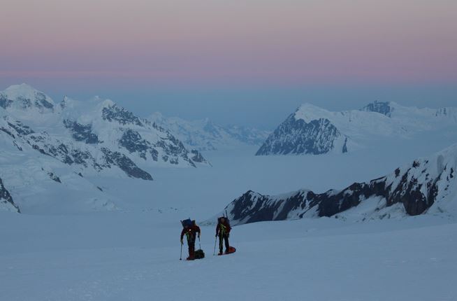
Climbers continue towards the Denali summit, with sleds is tow. The amount of gear required was too heavy for single backpacks, so each team member also pulled a plastic sled with equipment. The sleds were rigged to hold gear securely, allowing for some freedom of movement and set up to integrate into the teams’ climbing rope. However, when going downhill, the sleds can constantly bump the climbers and can awkwardly roll and pull. (Photo: Blaine Horner, CompassData)
Has the tallest mountain in North America shrunk? No, but advances in technology to measure and calculate precise elevations have resulted in a more accurate summit height of Alaska’s most magnificent natural treasure.
Denali remains the highest mountain in North America, the fourth highest mountain in the world, and is one of the world’s renowned “Seven Summits”.Denali National Park, where the mountain is located, was established in 1917 and annually sees more than 500,000 visitors to the 6 million acres that now make up the park and preserve. About 1,200 mountaineers attempt to summit the mountain each year; typically about half are successful.
Why Re-Survey Denali?
Surveyors, mappers, geodesists and other scientists, as well as climbers and mountaineers from around the world have long had a curiosity to know the official elevation of Denali.
“No place draws more public attention to its exact elevation than the highest peak of a continent. Knowing the height of Denali is precisely 20,310 feet has important value to earth scientists, geographers, airplane pilots, mountaineers and the general public. It is inspiring to think we can measure this magnificent peak with such accuracy,” said Suzette Kimball, USGS acting director. “This is a feeling everyone can share, whether you happen to be an armchair explorer or an experienced mountain climber.”
Researchers wanted to establish a baseline for future investigations of whether the mountain itself and/or its ice and snow pack changed significantly over time. This new survey measured the top of the snow and by using a snow probe determined the snowpack to be about 13.6 feet deep.
In 2013, the then-current summit elevation of 20,320 feet was called into question when a report was released stating an updated estimate of 20,237 feet near the summit. This newer number was collected from airborne radar using an Interferometric Synthetic Aperture Radar (ifsar) sensor. Ifsar is an extremely effective tool for collecting map data in challenging areas such as Alaska, but it does not provide precise spot or point elevations, especially in very steep terrain. This measurement was part of a larger project to collect revised elevation for the entire state under a national initiative called the 3-Dimensional Elevation Program, or 3DEP.
Formation of a Survey Party
The USGS, along with NOAA’s National Geodetic Survey (NGS), and the University of Alaska Fairbanks (UAF), were the primary partners supporting the physical assessment. Surveying technology and processes have significantly improved since the last survey and the ability to establish a much more accurate height now exists, so the climbers used Global Positioning System (GPS) equipment on the Denali apex.
The survey party was led by CompassData, a subcontractor for Dewberry, under contract to the USGS. The team consisted of four experienced climber/scientists – one from UAF and three from CompassData.
“The USGS is proud to be part of this remarkable accomplishment along with our partners,” said Kevin Gallagher, USGS Associate Director for Core Science Systems. “Creating more accurate elevation data across the nation is the goal of our 3-Dimensional Elevation Program. Having an accurate elevation for North America’s highest peak is consistent with that goal.”
Trek to the Top
For being one of the coldest places on earth, Denali can also be quite warm on the lower mountain. To take advantage of a narrow window for “good weather” on Denali, the team began their precarious trek to the summit in mid-June, with scientific instruments in tow. The team consolidated the appropriate food, clothing, shelter, survival gear and scientific equipment in the Anchorage area. On June 15, the group of four took the 40 minute flight from the Talkeetna Airport near the entrance of Denali National Park onto the Kahiltna Glacier to begin their ascent.
Processing the Data and Determining the New Elevation
To ensure the most accurate elevation number, specialists from CompassData, the University of Alaska Fairbanks and NOAA’s National Geodetic Survey all independently processed the survey data. Once they had preliminary results, a meeting was held to compare those calculations. All findings were very consistent and remaining questions focused on how to express the new height. Ultimately, an agreement was reached in terms of the reference surface to be used and the rationale for using the North American Vertical Datum of 1988 (NAVD 88) as the vertical datum.
“The NGS is pleased to have worked with such outstanding scientists and come to an agreeable solution on a project of this magnitude,” said Dr. Vicki Childers, chief of NOAA’s NGS Observation and Analysis Division. “The NGS established the new elevation with respect to the North American Vertical Datum of 1988 (NAVD 88).”
NAVD 88 is the official vertical datum for Alaska in the National Spatial Reference System (NSRS), a system that is defined and maintained by NGS to provide a consistent coordinate system across the entire United States. A new effort underway at NGS to modernize the NSRS by 2022 will incorporate an improved model of where the average sea level, or ‘zero’ elevation, is located; this will result in elevation values being more accurate with respect to mean sea level.”
Final Results – A Difference of 10 Feet Says A Lot
The final elevation number is remarkably close, within 10 feet, of the previous official elevation number. This is a testament to the skills and determination of the early surveyors and mountaineers who, with considerably less sophisticated equipment, calculated an elevation that stood the test of time. It’s only now, with major advances in GPS technologies, that a more precise elevation could be calculated.
The similarity between the new number and previous surveys validates notions that the summit snowpack remains nearly constant year to year. And finally, it answers the ultimate question by establishing a revised official elevation of 20,310 feet for the top of Denali.