Using the power of Geographic Information Systems to track trends in everything from demographic information to pesticide and chemical use like the Pesticide Use Reporting (PUR) system in California, used in the study I talked about here
There’s also the National Archive of Criminal Justice Data, filled with GIS information about crime in various areas around the country. But there’s more.GIS is used to map history as well. Why is that useful?

Photo Credit: Flickr
Archeologists geocode information as they discover ancient sites and unearth artifacts, and Google Ancient Places links this information to historical texts, a fascinating boon to researchers in several fields. By georeferencing old maps, a user can look at paces in London in 1746. These projects have both a practical application for research and a “wow” factor to raise awareness of GIS capability.
However, there are even more practical applications of GIS in relation to the environment. A small but powerful example lies in a small, silver rich valley in North Idaho that also happens to be one of the largest Superfund sites in the country. Not only is the area of interest in the application of CERCLA law, the law governing EPA Superfund actions, but in the application of GIS software.
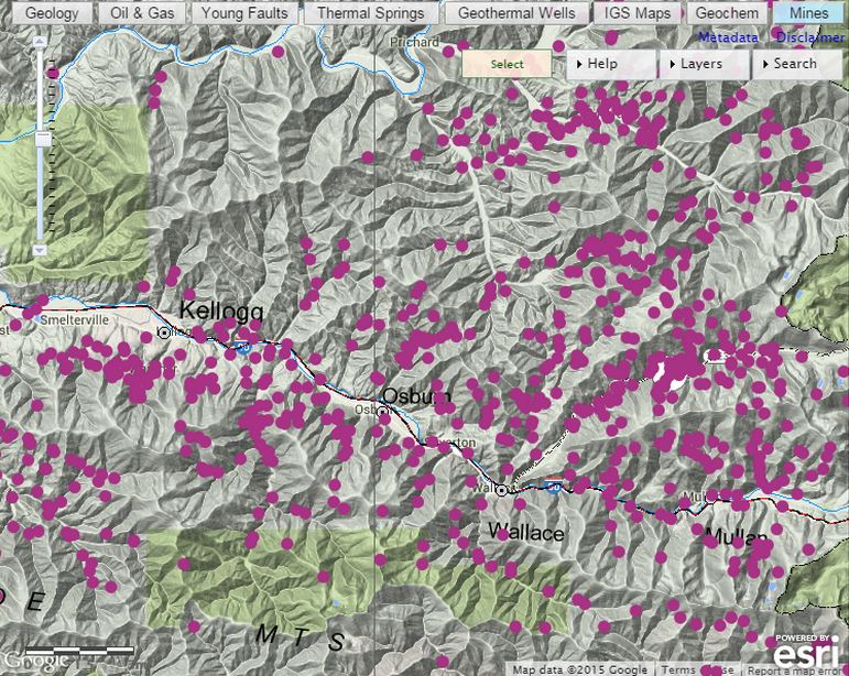
Photo Credit: Idaho Geological Survey, ESRI
Shoshone County, Idaho, where the valley is located, has over 600 historic and active mine sites and prospects according to the Idaho Geological Survey. Over 300 of these were listed as sites that might be in need of cleanup action by EPA Region 10 in a document called a Record of Decision, issued in 2001. Local historians and residents quickly objected that cleanup at many of those sites would be a waste of money. The reason? No real mining happened at those locations: Many were just prospect holes. But because of the nature of CERCLA law, once they were on the list, the EPA needed to prove they should not be.
So they turned to GIS, the Idaho Geologic Survey, information in the University of Idaho Special Collections, and the Wallace District Mining Museum, who put it all together. Long before satellite mapping, the United States Department of Agriculture (USDA) and the Forest Service conducted frequent aerial photography of the area, including in 1937, 1945, 1967, and 1974. Since much of the mining activity in the area concluded or wound down by the 1930’s, the 1937 and 1945 photos proved particularly useful.
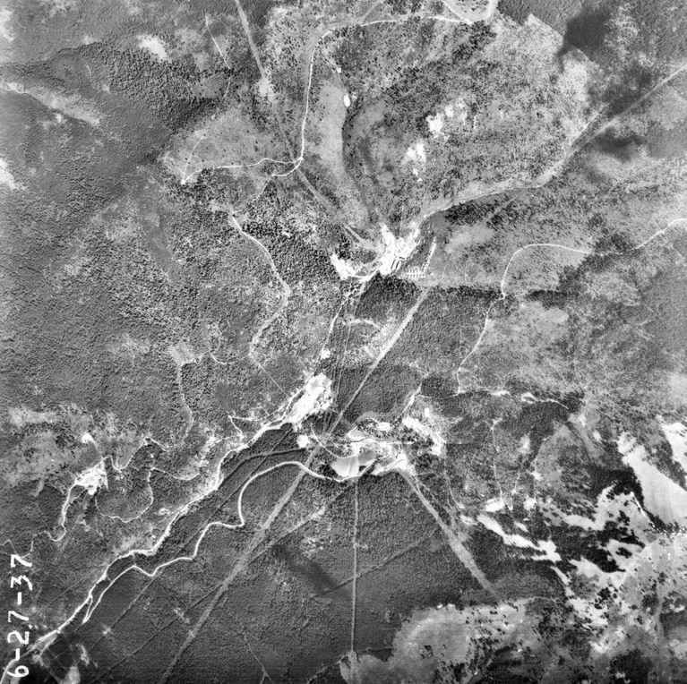
1937 Photo of the Interstate Mine area, Shoshone County, Idaho. Photo Credit: USDA
Georeferencing the photos, taken from a plane and often at an angle, proved challenging. But when combined with mineral information from the Idaho Geological Survey, and on the ground reports done by the United States Geological Survey office in Spokane, Washington, the past could be pieced together.
The photos and supporting information not only revealed old structures and waste plies, but also the lack of activity on certain sites. As a result of this research, over 90 sites were removed from the list, and more are still being researched. Also, the EPA and other agencies operating in the area have a much better idea about what actually happened at each mine site, and where cleanup efforts need to be concentrated, potentially saving millions of dollars.
There are thousands of aerial photographs of many areas of the country, and many are available here, or at local Forest Service offices. The potential applications are astounding, from vegetation and climate changes to wildlife migration patterns and many more.
We can use the past to inform the present. What we learn from history can help to shape our future, and the creative application of GIS can help.
Author:
Troy Lambert is a freelance writer, editor, and non-profit consultant by day, and a suspense thriller author by night. He learned about the power of GIS while working as a researcher at a museum, and is always looking for ways to apply this technology and big data in new and innovative ways. Troy is an avid cyclist, skier, and hiker. He lives, works, and plays in Boise, Idaho. His work can be found at troylambertwrites.com, and you can connect with him on Twitter @tlambertwrites.