Valencia, Spain, Centennial CO, – DIELMO 3D S.L., (www.dielmousa.com) Dielmo 3D is pleased to announce the launching of the Web Portal of OHIO, a 100% CUSTOMIZABLE LiDAR/GIS WEB-PORTAL for the State of Ohio. The demonstrative online GIS web-portal for Ohio is derived from publicly available LiDAR and GIS datasets, providing easy access to the data, as well as displaying them in 3D, and downloading or measuring the data among other features.
Dielmo 3D Introduces the Launching of Web Portal OHIO!
Ohio’s web portal can be accessed here:http://www.dielmo.com/demos/
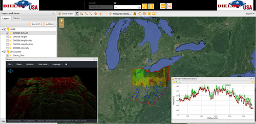
Dielmo Server Technology allows the visualization of LiDAR data (aerial, mobile and terrestrial), DTM’s and ortho photos using Web Mapping Services (WMS), an OGC standard, to visualize original LiDAR point-cloud data that can be represented in different styles (height, intensity, RGB or classification) without having to distribute the original data.
“This is an example of how easy it is to access LiDAR and GIS data on the web thanks to Dielmo 3D’s technology …there is available LiDAR data for Ohio’s, and thanks to our technology it can be made accessible online for anyone to access and use,” said Jose Carlos Garcia, president, Dielmo 3D.
“Be the first to include LiDAR as well as DEM, WMS/WFS services and imagery to your online web-portal, or contact us to learn how we can create your own web-portal starting at $5,000, including design, tools and LiDAR plus GIS datasets publication.”
Dielmo’s 3D Viewer provides outstanding 3D Visualization allowing users to set preferences for display of the 3D point cloud, while the Dielmo LiDAR profile client allows complete analysis of the LiDAR data including editing, measurement and export tools. The 3D LiDAR Points Client is open source software that allows the visualization of LiDAR point cloud data in 3D over the internet. Any user, expert or not in LiDAR data, will be able to display a point cloud in 3D online, choose a visualization mode (Height, Intensity, Classification, RGB) and to change the size of the points, all without having expert software for managing LiDAR data. It can easily be integrated in any web browser or GIS software.
It is amazingly easy to get started: All that is necessary is to provide a dataset of LiDAR data (LAS, DTM, DSM, or other raster layers), Dielmo will provide an FTP site to upload the files or put the data on their own FTP, and provide the coordinate system of the data. Dielmo Server Technology allows visualization of LiDAR point clouds and orthophotos as a WMS layer inside a website, make profiles on the LiDAR point cloud using the profiles client and display the point cloud in 3D.
About DIELMO 3D S.L.
Since 2003, DIELMO (DIgital ELevation MOdels) offers a broad range of products and services connected with Digital Terrain Models (DTM) and Remote Sensing, and focusing its efforts on internal research projects creating their own technology for production, quality control and distribution of geographic information.
DIELMO has become one of the main DTM, digital cartography, acquisition and LiDAR processing and virtual scenarios generation providers in Spain, offering total geographic information solutions and is now in the process of offering their technology to the international community. For more information contact: Central Office : Plaza Vicente Andrés Estellés nº2 Bajo. 46950 Xirivella, Valencia; Tel./Fax: +34 963 137 212; www.dielmo.com , E-mail: rafa@dielmo.com
###