NEWTON, MASSACHUSETTS (USA) – Maptitude 2015 is due out in the first quarter of 2015, and we are offering you an exclusive first look at some of the new features. Maptitude 2015 provides the most up-to-date and accurate maps and demographics available, encompassing the latest streets, postal codes, business locations, census data, and more.
Maptitude 2015 improves upon a number of areas of the software. One of the key areas Maptitude 2015 focuses on is significant enhancement of reporting capabilities. The improvements to the latest edition of Maptitude will make it even easier to present and share the results of your analysis in concise and informative formats.
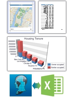
Maptitude now supports completely new ways to share your data including single click exports to Microsoft Excel, cutting-edge charts, and PDF reports.
 Reports
Maptitude 2015 allows you to use the Drawing Toolbar to create a shape and then export data directly to Excel, simply by right clicking on the map.
With Maptitude 2015, the reporting tools introduced in the 2014 version are available for every analysis tool. The tools have been redesigned to be much more intuitive, and to allow for report personalization.
Charts
Maptitude 2015 provides a comprehensive set of over 32 chart types that address a broad range of business needs with ease. You can create 2-D and 3-D charts, and perform multi-dimensional data analysis and reporting.
Data Sharing
Maptitude 2015 continues to support the latest data standards and file formats with new import capabilities for Google Maps, Microsoft MapPoint, and Excel. You can also save to Microsoft Excel XLSX and create PDF files for reports and charts.
More to come! There are many improvements in Maptitude 2015. Stay tuned for additional information! Please contact the Maptitude Sales Team with any questions.
About Caliper
Caliper Corporation develops state-of-the-art Geographic Information Systems (GIS) software. With a focus on usability, Maptitude is designed to be a cost-effective, professionalmapping software product. Maptitude enables organizations to leverage their location-based data to improve decision making and planning, while minimizing expenditure through competitively priced solutions.
Caliper is a privately held corporation and is a leading developer of mapping, redistricting, transportation, and GIS software.