GIS user technology news

News, Business, AI, Technology, IOS, Android, Google, Mobile, GIS, Crypto Currency, Economics

  • Advertising & Sponsored Posts
    • Advertising & Sponsored Posts
    • Submit Press
  • PRESS
    • Submit PR
    • Top Press
    • Business
    • Software
    • Hardware
    • UAV News
    • Mobile Technology
  • FEATURES
    • Around the Web
    • Social Media Features
    • EXPERTS & Guests
    • Tips
    • Infographics
  • Blog
  • Events
  • Shop
  • Tradepubs
  • CAREERS
You are here: Home / * PRESS / Software / SuperSurv 3.2 Release Advanced GPS Support and Data Collection Functions

SuperSurv 3.2 Release Advanced GPS Support and Data Collection Functions

December 23, 2014 By GISuser

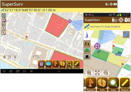
Developed by Supergeo, the latest version of SuperSurv (Android) 3.2 is upgraded with stronger data collecting function by GPS and more precise and easy-to-use GPS manipulation interface, bringing more convenient and intuitive user experience.

SuperSurv is an efficient mobile GIS app designed for field data collection on iOS and Android platforms. The GIS app not only supports users to collect spatial and attribute data, but also provides attribute query, tracklog recording and display, adding Waypoint, etc.

Integrating with GIS and GPS technologies, SuperSurv provides useful functions like Map Display, Query, Measure, etc., and supports to overlay OpenStreetMap as the basemap. Also, users may capture point, line and polygon features and attribute data, and save the data as SHP or GEO format in both offline and online modes.

The new SuperSurv 3.2 has enhanced GPS status bar to show the positioning information with more details like Horizontal Accuracy, Vertical Accuracy and Current Satellite Numbers. Moreover, data collecting function with GPS has been strengthened to provide better positioning efficacy and more accurate data collect settings.

One of the most important inclusions in the new release is the real-time NMEA information for advanced usage, which allows SuperSurv 3.2 users to view or save the GPS records correctly.

To download newest SuperSurv 3.2 free trial

AppStore:
https://itunes.apple.com/us/app/supersurv/id734191604?mt=8

GooglePlay:
https://play.google.com/store/apps/details?id=com.supergeo.asd.supersurv_lite.SuperSurv

Learn More about SuperSurv 3.2
http://www.supergeotek.com/ProductPage_SuperSurv.aspx
 

Filed Under: Software Tagged With: SuperSurv

Editor’s Picks

Esri Story Map Reveals Where Your Thanksgiving Dinner Comes From

Esri Indonesia Story Map Explores Missing AirAsia Flight 8501

Maps attributed to the 13th-century traveler sketch what looks like the coast of Alaska

Infographic – What’s New in iOS 8?

See More Editor's Picks...

Recent Industry News

Furnace Repair: Fast Fixes for a Warm, Worry-Free Home

September 15, 2026 By GISuser

Aerial Surveys International Awarded GSA Multiple Award Schedule Contract

September 12, 2026 By GISuser

New Episode Alert: The Colorado State University (CSU) Drone Center

September 10, 2026 By GISuser

Increase Rev vs. Google AdSense: Unlocking 50%–200% Higher Earnings

August 17, 2026 By GISuser

Hot News

State of Data Science Report – AI and Open Source at Work

HERE and AWS Collaborate on New HERE AI Mapping Solutions

Virtual Surveyor Adds Productivity Tools to Mid-Level Smart Drone Surveying Software Plan

Categories

Copyright gletham Communications 2015 - 2026

Go to mobile version