GISuser.com

GIS and Technology news for mapping professionals

  • PRESS
    • Submit PR
    • Top Press
    • Business
    • Software
    • Hardware
    • UAV News
    • Mobile Technology
  • FEATURES
    • Around the Web
    • Social Media Features
    • EXPERTS & Guests
    • Tips
    • Infographics
  • Events
  • CAREERS
  • Advertise
    • Advertise
  • Blog
  • Shop
  • Tradepubs
You are here: Home / * PRESS / Webinars / Supergeo to Provide Free Online GIS Web Courses

Supergeo to Provide Free Online GIS Web Courses

July 28, 2014 By GISuser

To well promote GIS technologies in real case application, Supergeo is going to provide free online GIS web courses. From basic to advanced, the courses will introduce GIS software on various platforms. Through the course, users can not only gain geospatial knowledge but have a comprehensive understanding of SuperGIS software operation and application.

Supergeo has been dedicated to providing total GIS solutions for worldwide users and enabling personnel in diverse domains to apply spatial technologies to different systems, such as desktop, server, mobile devices, web services, etc.

To make GIS technologies more accessible, Supergeo is going to release a series of free online web courses to let worldwide users to easily learn GIS anytime and anywhere. The courses will show you:

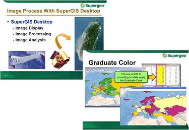
? Desktop GIS: the use and application of SuperGIS Desktop and extensions, analysis functions in SuperGIS Toolkit, image data processing, etc.
? Server GIS: publishing map services and customizing JavaScript map website with SuperGIS Server, the applications of Mobile SDK, and so on.
? Mobile GIS: collecting spatial data with smart devices, recording GPS tracklog, view waypoints with Augmented Reality in SuperSurv (for iOS), etc.

With the content-rich courses, users will be able to understand GIS technologies and through SuperGIS on different platforms to understand different real-case application in various domains. So that users can have accurate GIS analysis to support their professional needs.

To get more technical resources of SuperGIS products, please visit Supergeo Developer Network website (http://sgdn.supergeotek.com/) and also feel free to contact usstaff@supergeotek.com. 


Related Articles on GISuser:

  • kubit Webinar Series – Software for Surveying and As-Built Documentation kubit Webinar Series – Software for Surveying and As-Built Documentation
  • Webinar in English (July 31st): ‘gvSIG Applied to Environment’Webinar in English (July 31st): ‘gvSIG Applied to Environment’
  • Learn How to Achieve Interoperability Using the Esri ArcGIS Platform and OGC StandardsLearn How to Achieve Interoperability Using the Esri ArcGIS Platform and OGC Standards
  • Urban Infrastructure Monitoring with Space-based Radar – Free WebinarUrban Infrastructure Monitoring with Space-based Radar – Free Webinar
  • Get all your contour mapping questions answered in the Surfer 12 FAQ webinarGet all your contour mapping questions answered in the Surfer 12 FAQ webinar
  • Webinar gvSIG Educa/Batoví, An Educational Tool for Teaching GIS in Schools (June 11th)Webinar gvSIG Educa/Batoví, An Educational Tool for Teaching GIS in Schools (June 11th)

Filed Under: Webinars, Webinars and Online Training Tagged With: News, Supergeo to Provide Free Online GIS Web Courses, Webinars and Online Training


Editor’s Picks

How Privacy Concerns Will Shape LiDAR Applications Using UAS

Feature – How Privacy Concerns Will Shape LiDAR Applications Using UAS

Feature – GIS and the NFL: Sustainability and Millennial Fans

Feature: Social Media Mapping is Crucial for Market Research and your Social Strategy

2014 Open Data for Development Research Grants – Call for Proposals

See More Editor's Picks...

Feed

  • RSS


GIS jobs


Recent Features

Digitalization and Simulation at the North Pole

Natural Gas District & GIS-Centric Asset Management

5 Ways Technology Is Affecting The Sharing Economy

Spotlight – Township Canada: Explore Canadian Legal Land Descriptions on a Map

GeoGeeksinCars – The one in “Tippy” the right-hand drive Mitsubishi, at DevSummit

More Posts from this Category

Categories

Recent Posts

  • NOAA predicts above-normal 2022 Atlantic Hurricane Season
  • Space logistics markets ready to grow as on-orbit supplier services materialize
  • Applications Invited for URISA’s Vanguard Cabinet
  • The Rise of Ryoshis Vision ($RYOSHI) as It Takes a Revolutionary Approach to the Crypto Market
  • Tips for Working on a Computer All Day

RSS Career Tips

  • Four Characteristics of the Best Virtual Employees
  • 8 Questions Employers Should Ask About Coronavirus
  • Jobcase Launches Free Unemployment Resource Center for Workers Impacted by COVID-19
  • Must-Have Gadgets and Technology for the Remote Office Worker
  • Must-Have Gadgets and Technology for the Remote Office Worker


shop for geogeek swag

RSS Tech pubs

  • Recruiting Metrics for the Modern Recruiter
  • Metrics for the Modern Recruiter
  • Learn to Optimize High-Volume Recruitment Planning

RSS Computers

  • HackerProof: Your Guide to PC Security
  • Windows... On Speed
  • The Idiot's Ultimate Guide to Build Your Own PC

RSS HR Tips

  • Learn to Optimize High-Volume Recruitment Planning
  • 2022 Restaurant & Retail Talent Acquisition Predictions Report
  • Talroo's 2022 Complete Restaurant Hiring Playbook

RSS Gov Tech

  • Flexibility, Work-Life Balance, and Job Satisfaction: Why More Lawyers Are Seeking Career Alternatives
  • Clio: Guide to Law Office Automation
  • The 11 Habits of Highly Successful Law Firms

RSS UAV news

  • UAS Drone Subsidiary, Duke Robotics’, Sniper Drone showcased at a leading International Airshow in the Asia Pacific Region
  • Short Battery Life: A Drone’s Worst Enemy
  • UMAV ANNOUNCES ITS LIGHTER THAN AIR DETACHABLE DRONE IS COMPLETING FINAL AVIONICS INSTALLATION

RSS Geojobs

  • Help Desk Technician
Copyright Spatial Media LLC 2003 - 2015