GIS user technology news

News, Business, AI, Technology, IOS, Android, Google, Mobile, GIS, Crypto Currency, Economics

  • Advertising & Sponsored Posts
    • Advertising & Sponsored Posts
    • Submit Press
  • PRESS
    • Submit PR
    • Top Press
    • Business
    • Software
    • Hardware
    • UAV News
    • Mobile Technology
  • FEATURES
    • Around the Web
    • Social Media Features
    • EXPERTS & Guests
    • Tips
    • Infographics
  • Blog
  • Events
  • Shop
  • Tradepubs
  • CAREERS
You are here: Home / *FEATURES / EXPERTS / Infographic – The Past and Future of Drones in the U.S.

Infographic – The Past and Future of Drones in the U.S.

June 4, 2014 By Editor

Americans have a long love affair with aviation, so why should unmanned aviation be any different? Truth is, it probably won’t be, as tens of thousands of unmanned aerial vehicles, also known as drones, will launch into the skies over the U.S. in the next couple of decades. What’s our history with drones, how are they being used, what’s to come, and what are some of the legal issues with expanding the use of civilian drones?

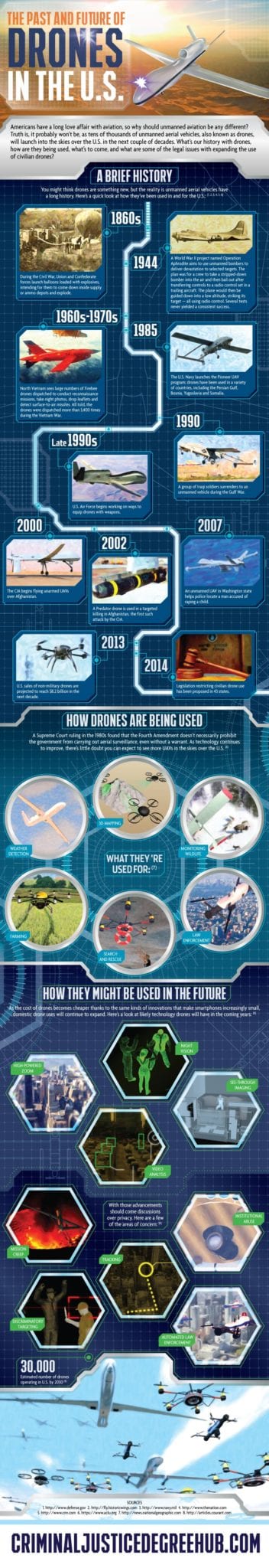
How Drones Are Being Used

A Supreme Court ruling in the 1980s found that the Fourth Amendment doesn’t necessarily prohibit the government from carrying out aerial surveillance, even without a warrant. As technology continues to improve, there’s little doubt you can expect to see more UAVs in the skies over the U.S. (6)

What they’re used for: (7)

  • Weather detection
  • 3D mapping
  • Monitoring wildlife
  • Farming
  • Search and rescue
  • Law enforcement

How They Might Be Used in the Future

As the cost of drones becomes cheaper thanks to the same kinds of innovations that make smartphones increasingly small, domestic drone uses will continue to expand. Here’s a look at likely technology drones will have in the coming years: (6)

  • Night vision
  • High-powered zoom
  • See-through imaging
  • Video analysis

With those advancements should come discussions over privacy. Here are a few of the areas of concern: (6)

  • Mission creep
  • Tracking
  • Discriminatory targeting
  • Institutional abuse
  • Automated law enforcement

Drones
Source: CriminalJusticeDegreeHub.com
See more details from http://www.criminaljusticedegreehub.com/drones-future/


Filed Under: EXPERTS, Infographics, THE EDITOR, UAV/UAS Tagged With: editor, expert, Experts, feature, gletham, infographic, News, Select Category, UAS, UAV

Editor’s Picks

OpenAerialMap – The open collection of aerial imagery

Call For Papers – Location Based Services 2015 Innovate with Location Data

Esri Map Book Illustrates How the US Government Uses GIS

Infographic – What’s New in iOS 8?

See More Editor's Picks...

About Editor

Glenn is a geographer and a GIS professional with over 20 years experience in the industry. He's the co-founder of GISuser and several other technology web publications.

Recent Industry News

The Drift Between Early Notes and Final Case Files in Abuse-Related Legal Support

April 29, 2026 By GISuser

Aerial Surveys Int’l and Global Marketing Insights to Present GEOINT 2026 Workshop on Multi-Domain Geospatial Fusion for Automated Infrastructure Monitoring

April 24, 2026 By GISuser

Why Timing Matters More Than You Think With Spray Seal (And Why People Often Get It Slightly Wrong)

April 22, 2026 By GISuser

The Quiet Planning Stage Most People Don’t See When Building a Pool in Brisbane

April 22, 2026 By GISuser

Hot News

State of Data Science Report – AI and Open Source at Work

HERE and AWS Collaborate on New HERE AI Mapping Solutions

Virtual Surveyor Adds Productivity Tools to Mid-Level Smart Drone Surveying Software Plan

Categories

Copyright gletham Communications 2015 - 2026

Go to mobile version