GIS user technology news

News, Business, AI, Technology, IOS, Android, Google, Mobile, GIS, Crypto Currency, Economics

  • Advertising & Sponsored Posts
    • Advertising & Sponsored Posts
    • Submit Press
  • PRESS
    • Submit PR
    • Top Press
    • Business
    • Software
    • Hardware
    • UAV News
    • Mobile Technology
  • FEATURES
    • Around the Web
    • Social Media Features
    • EXPERTS & Guests
    • Tips
    • Infographics
  • Blog
  • Events
  • Shop
  • Tradepubs
  • CAREERS
You are here: Home / Blog / Canada / Canada will try to extend its territorial claims in the Arctic and North Pole

Canada will try to extend its territorial claims in the Arctic and North Pole

December 9, 2013 By Editor

An interesting announcement regarding some Arctic land claim issues… A formal scientific submission was made to the United Nations Commission on the Limits of the Continental Shelf last week covering 1.2 million square kilometres of territorial claims in the Atlantic, but the government says material submitted for the Arctic Ocean is only preliminary.

Canasda to claim North Pole

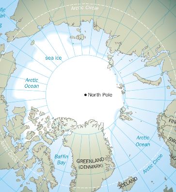
Despite saying two years ago that data collection was complete, the federal government plans to send its scientists back into the field for more work mapping a giant undersea mountain range that Ottawa says could secure the sea floor under the top of the world for the Maple Leaf.

Read more HERE

Filed Under: Canada, santa

Editor’s Picks

Using Lidar to Classify Landslides

First Look – Los Angeles Opens the GeoHub – #OpenData for Citizens and Developers

Join Esri, IBM, Amazon at the AT&T Mobile App Hackathon – Los Angeles

Maps attributed to the 13th-century traveler sketch what looks like the coast of Alaska

See More Editor's Picks...

About Editor

Glenn is a geographer and a GIS professional with over 20 years experience in the industry. He's the co-founder of GISuser and several other technology web publications.

Recent Industry News

The Future of Competitive Gaming: Why DMA Technology is the Ultimate Performance Edge

June 24, 2026 By GISuser

Milwaukee M18FHZ-0 Hackzall Reciprocating Saw – For hardcore cutting in a compact size

June 19, 2026 By GISuser

How Enterprises Are Using AI to Automate 80% of Customer Interactions With Voice Agents

June 16, 2026 By GISuser

Why On Cloud Shoes Are Worth the Price in Mexico

June 16, 2026 By GISuser

Hot News

State of Data Science Report – AI and Open Source at Work

HERE and AWS Collaborate on New HERE AI Mapping Solutions

Virtual Surveyor Adds Productivity Tools to Mid-Level Smart Drone Surveying Software Plan

Categories

Copyright gletham Communications 2015 - 2026

Go to mobile version