Supergeo announces that the new full-function mobile GIS application, SuperPad 3.1a, is going to be released.
SuperPad is a full-function mobile GIS application designed for mobile GIS and field mapping applications. SuperPad can be applied on diverse mobile devices or handheld devices to assist field surveyors in tasks like spatial data collection, editing and measurement in the field and improve data validity and usability effectively.
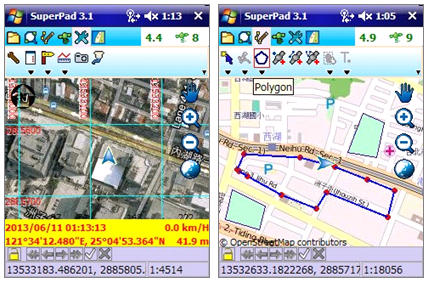
The newest version, SuperPad 3.1a, mainly adds Online Map Tool; therefore, users can apply OpenStreetMap as the basemap in field survey. Meanwhile, it supports GPS satellite extension for users to comprehend real-time GPS signal information. Additionally, SuperPad 3.1a enhances its manipulation and editing function to support feature measurement and improve connection with SuperGIS Server services and the editing task.
To improve the accuracy of data collection, SuperPad 3.1a provides GNSS driver that can record the data of satellite signal when surveyors are collecting spatial data. Then, users can load the collected data to SuperGIS Desktop 3.1a and adjust the data through DGPS Add-on to get more precise spatial data.
SuperPad 3.1a is going to be released soon. To know the newest product information, please visit Supergeo website: http://www.supergeotek.com/ProductPage_SP3.aspx?Type=Overview , or contact us with e-mail: staff@supergeotek.com.