GIS user technology news

News, Business, AI, Technology, IOS, Android, Google, Mobile, GIS, Crypto Currency, Economics

  • Advertising & Sponsored Posts
    • Advertising & Sponsored Posts
    • Submit Press
  • PRESS
    • Submit PR
    • Top Press
    • Business
    • Software
    • Hardware
    • UAV News
    • Mobile Technology
  • FEATURES
    • Around the Web
    • Social Media Features
    • EXPERTS & Guests
    • Tips
    • Infographics
  • Blog
  • Events
  • Shop
  • Tradepubs
  • CAREERS
You are here: Home / Software / GIS Application Story – Agriculture Field Survey System

GIS Application Story – Agriculture Field Survey System

August 13, 2013 By Editor

Indonesia is an emerging country in Southeast Asia. Its agriculture production annually contributes to 15% of GDP, and the farm labor accounts for up to 43% employment of Indonesian economy. To improve the agricultural development, Indonesia government injects more than 7 million US dollars annually to provide diverse grant-in-aid projects, and Ministry of Agricultural Republic of Indonesia (MoA) also gives assistances including funding, seeds, insecticide, etc, based on farmland size and the type of crops.

To utilize agriculture-related funding effectively, report the real and current situation of farmland and crops, and avoid faulty spending or unnecessary waste, MoA of Indonesian government decided to replace paper-based and artificial work with GIS technologies to scientifically and objectively record farmland size, the type of crops, and so forth. Hence, MoA can efficiently spend funding and centrally manage the relevant information of farmland in the country.

Agriculture Field Survey System—Mobile GIS
 
Goals

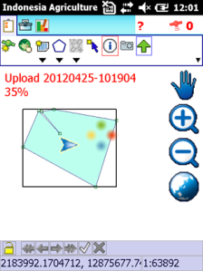
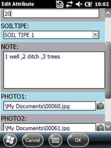
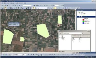
To precisely record and manage the relevant information of each farmland, such as the real farmland area measurement, the type of crops, and so on, MoA needs a GIS solution of Agriculture Field Survey System integrating with spatial data collection function on mobile devices, editing and analysis function on desktop side, and spatial data management on server side.

Farmers from each province are allowed to use mobile GIS and GPS function to record farmland area and also enter attributes and take pictures to record the crops in the farm. The collected data can be sent to the server of MoA and be managed centrally. Thereby, the personnel in MoA can comprehend the authentic situation of farmland, like size, crop type, etc with the database and the website.

 
Solutions

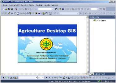
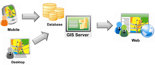
Agriculture Field Survey System contains customized Server GIS, Desktop GIS and Mobile GIS.

1. Server GIS:
Adopting SuperGIS Server 3.1a as service server, the Server GIS is capable of centrally managing, publishing vector data and raster data of each province so that users can employ various front-end applications to view, query and edit the map. To make sure the data accuracy, the newest field survey result surveyed by farmers in the country can be uploaded to SuperGIS Server 3.1a through the Internet as well.

2. Desktop GIS:
SuperGIS Desktop 3.1a helps MoA integrate diverse types of spatial data and save these files as projects that can be published as map services by SuperGIS Server 3.1a. In addition, SuperGIS Desktop 3.1a also supports various spatial databases that would not only have data sharing more convenient, but also support multi-user online accessing and editing the data. Therefore, the data usage can be significantly improved.

3. Mobile GIS:
Agriculture Field Survey System is the spatial data collection software that adopts SuperPad 3.1 as the core and integrates local users’ using behavior with geographic features. The system is capable of assisting farmers in collecting, editing and measuring the spatial data in fields directly. What users need to do is load the required data to SuperPad 3.1 through the Internet, and upload the newest survey result to server after accomplishing data collection. Therefore, vast amount of time for task preparation can be shortened, productivity be improved, and centralized management be employed as well to maintain data accuracy and consistency.

Complete Solution of Agriculture Field Survey System
 
Results
Agriculture Field Survey System is primarily composed of Mobile GIS (SuperPad 3.1), Desktop GIS (SuperGIS Desktop 3.1a), and Server GIS (SuperGIS Server 3.1a). These 3 products are respectively customized at different levels to match project requirements and help Indonesian local users to manipulate more easily.
1. Mobile GIS-Agriculture Field Survey System:
 

To facilitate manipulation for Indonesian users, this project customized SuperPad 3.1 as Indonesia Agriculture Field Survey System. In addition to spatial data overlaying, feature and attribute data adding and editing, the system provides customized items such as Indonesian user interface, splash for MoA, frequently used tools, etc. Besides, the system provides built-in Indonesian coordinate system and removes non-used ones to simplify the user interface. For local users, the system helps them enhance the efficiency of data collection significantly.

Over the Internet, farmers in Indonesia can load the required map data from SuperGIS Server 3.1a and display in Agriculture Field Survey System and conduct tasks in fields directly, including GPS positioning, spatial data and attribute data collection, measurement, etc. After the field survey is accomplished, the newest data can be uploaded to synchronize the data in SuperGIS Server 3.1a through the Internet as well.


The collected data can be synchronized
with the data in SuperGIS Server 3.1.

Users can enter attributes and take
pictures to record the status of the farm.

   
2. Desktop GIS-SuperGIS Desktop 3.1a:
 

In this project, SuperGIS Desktop 3.1a is customized as SuperGIS Desktop for Indonesia, providing Indonesian interface and the custom splash for MoA.

MoA adopts SuperGIS Desktop 3.1a to integrate vast amount of spatial data of every province and save these data as project that can be published as map service by SuperGIS Server 3.1. Thus, the central government offices can apply the map services to examine and compare with the collected data. Additionally, SuperGIS Desktop 3.1a supports various spatial databases including Personal Geodatabase (mdb), SQL Server, and Oracle Spatial. It not only facilitates resource sharing and interoperability, but also supports multiuser to access, edit the data online, and improves the data usage.


3. Server GIS-SuperGIS Server 3.1a:
 

Adopting SuperGIS Server 3.1a as service server, this Server GIS is capable of centrally managing and publishing vector data and raster data of each province. Therefore, users can employ various front-end applications, like SuperPad, SuperGIS Desktop, browsers, etc to view, query, and edit the map. To make sure the data accuracy, the newest field survey result collected by farmers can be uploaded to SuperGIS Server 3.1a through the Internet. Consequently, SuperGIS Server 3.1a enables personnel of MoA to cope with farm and crop status in every district and manage all the data centrally.


Users can view and query the collected data with browsers.

Users are allowed to apply the tools to measure the map in website.
 
 
System Benefit

Cloud GIS solution of Agriculture Field Survey System provides MoA with a full-function platform that integrates farmland survey, data synchronization, spatial data management and sharing, etc. Through Agriculture Field Survey System (SuperPad), the farmland size in every district can be recorded scientifically and objectively, and the relevant information can be the references for MoA to decide the subsidy. Besides, with SuperGIS Desktop 3.1a, the spatial data are integrated effectively, and the data can be shared through Geodatabase. Moreover, the data are centrally managed in SuperGIS Server 3.1a that significantly reduces the cost of data copy and storage and leverages task performance

More Supergeo features

Filed Under: Software Tagged With: Articles, GIS Application Story - Agriculture Field Survey System, software

Editor’s Picks

Feature – Oil and Water: Mapping the South China Sea

2015’s Best & Worst Metro Areas for STEM Professionals

Esri Indonesia Story Map Explores Missing AirAsia Flight 8501

Trimble Unity – Next Generation Suite of Software Applications for Water, Wastewater and Stormwater Utilities

See More Editor's Picks...

About Editor

Glenn is a geographer and a GIS professional with over 20 years experience in the industry. He's the co-founder of GISuser and several other technology web publications.

Recent Industry News

What Is In-Home Disability Care and How It Works With Five Good Friends

March 9, 2026 By GISuser

Eagleview White Paper Warns: Geospatial Intelligence Is About to Change Forever

March 4, 2026 By GISuser

Can You Use A Bong As A Dab Rig? What You Should Know

March 3, 2026 By GISuser

Hot News

State of Data Science Report – AI and Open Source at Work

HERE and AWS Collaborate on New HERE AI Mapping Solutions

Categories

Copyright Spatial Media LLC 2003 - 2015

Go to mobile version