GIS user technology news

News, Business, AI, Technology, IOS, Android, Google, Mobile, GIS, Crypto Currency, Economics

  • Advertising & Sponsored Posts
    • Advertising & Sponsored Posts
    • Submit Press
  • PRESS
    • Submit PR
    • Top Press
    • Business
    • Software
    • Hardware
    • UAV News
    • Mobile Technology
  • FEATURES
    • Around the Web
    • Social Media Features
    • EXPERTS & Guests
    • Tips
    • Infographics
  • Blog
  • Events
  • Shop
  • Tradepubs
  • CAREERS
You are here: Home / *FEATURES / THE EDITOR / Editing OpenStreetMap (OSM) Just Got Easy, Really Easy! Everything You Need to Know!

Editing OpenStreetMap (OSM) Just Got Easy, Really Easy! Everything You Need to Know!

May 9, 2013 By Editor

There’s no arguing that OpenStreetMap (OSM) has exploded in use and popularity, heck, just look at the basemap layer options in any online web mapping services and you’ll see OSM as an option. Often considered the wikipedia of the mapping world, OSM is a fabulous basemap option for anyone and perhaps coolest of all, OSM has been built and maintained by you – the crowd!

I’m sure that many (if not most) of you have often wanted to mess around with OSM and add/edit some features but were a little lazy – I’m guilty! But now we have no excuse thanks to the new OpenStreetMap in-browser map editing tools available from the iD Editor (think HTML5) – see the official OSM blog for the announcement and details.

So, how exactly does it work?

  • Well, to start you jump to http://www.openstreetmap.org/ then navigate to your favorite places or area of interest. For those of you wanting to try editing I suggest zoom in around your home, office, or other area that you know well. 
  • Look at.near the top left region of the browser (I’m using Chrome) and select the edit option. You’ll notice 3 options, the first one being Edit with iD (iD Editor for OSM http://ideditor.com) – this is the new, in-browser editor
  • You’ll then be prompted to login. If you have an OSM account simply login, otherwise, create an account – its painless and supports OpenID
  • when you select Edit in browser you’ll then notice that the map switches to a satellite view – vector layers will be shown on top of the imagery.  Navigate where you need to be
  • Add a Point, Line, or Area feature – think bike rack, bike trail, or bicycle park or store
  • Add the feature and then select the feature type from the options presented and load any other relevant attributes
  • Save – IMPORTANT!
  • Once finished you’ll then have the option to share your edit via Twitter and/or facebook, go ahead and tell your friends!
  • That’s it… keep on mapping ;0)

Pretty easy eh? Until now editing OSM was, well, a pain! IT wasn’t entirely hopeless but I ‘d say it was a little bit of effort and the UI wasn’t something you’d ask your mother to use. There’s a number of third party tools and options for editing OSM but I’m convinced once you try the new OSM editor you’ll be committed to helping grow the map and you may even want to get your Mom to help too since the new tools are so easy to understand and use!

Oh, and if you really don’t feel like adding or editing cartographic features you don’t have to, rather, you can always use the new "add a note" feature and drop a note with a little explanation of what you found or what you didn’t find – see details

The new OpenStreetMap Editor is so easy, I may just do some OSM map edits with my Mom this Mother’s Day!

Get started for yourself at http://www.openstreetmap.org
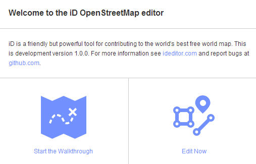

When you first visit the OSM website you’ll be presented with an optional demo

Editing features is so simple… add a point, line or area, include attributes, Save!

Once completed you can share your edits via Twitter or facebook

A sample Tweet


Shared via facebook also

Notice there are many features (like building footprints) not added. Every business should want to include their information in OSM!

From the foundation:

To accompany the expected growth in OSM’s contributor base, the OpenStreetMap Foundation is launching an appeal to fund new hardware for the project. The appeal aims to make the editing experience more resilient, so that the OSM community can continue producing the most extensive and up-to-date map of the world.

You can donate online at donate.openstreetmap.org.

Useful weblinks:

  • OpenStreetmap
  • OSM User blogs
  • Official OSM blog
  • OSM Editing Wiki
  • ArcGIS Editor for OSM
  • About the NodeID Project from MapBox
  • iD Editor for OSM http://ideditor.com
  • iD on github
  • donate.openstreetmap.org
  • Fuzzy Tolerance blog (@Mapperz) – iD is freaking awesome


Filed Under: THE EDITOR Tagged With: Editing OpenStreetMap (OSM) Just Got Easy, editor, Experts, Glenn Letham, Really Easy! Everything You Need to Know!

About Editor

Glenn is a geographer and a GIS professional with over 20 years experience in the industry. He's the co-founder of GISuser and several other technology web publications.

Top Press

The Global Expansion of Aueshah: A New Era of High Jewelry

April 11, 2026 By GISuser

KARACHI, PAKISTAN. The international luxury market is experiencing a profound shift. Consumers are increasingly rejecting mass-produced goods in favor of rarity, authenticity, and emotional depth. … [Read More...]

State of Data Science Report – AI and Open Source at Work

September 10, 2025 By GISuser

AI and Open Source at Work … [Read More...]

Topcon Announces Landmark Expansion of Topnet Live Network Across USA

January 26, 2025 By GISuser

LIVERMORE, Calif.---Topcon Positioning Systems has announced a significant expansion of its Topnet Live reference station network, introducing 200 new geodetic stations strategically positioned across … [Read More...]

Space Flight Laboratory (SFL) Announces Launch and Deployment of NorSat-4 Maritime Monitoring Microsatellite

January 19, 2025 By GISuser

Seventh Satellite Developed by SFL for Norway … [Read More...]

HERE and BMW Group extend partnership on AI-powered mapping system

January 8, 2025 By GISuser

HERE and BMW Group extend partnership on AI-powered mapping system for automated driving and enhanced road safety … [Read More...]

Everest Base Camp Helicopter Tour, Helicopter Return Trek, and Manaslu Circuit Trek: Which Nepal Adventure Is Right for You?

November 6, 2026 By GISuser

Almost everyone planning a Nepal trip runs into the same wall. You want the big mountains, you have a fixed number of days, and every itinerary you read seems to promise something … [Read More...]

SFL Missions Inc. Confirms Successful Deployment of Six HawkEye 360 Radio Frequency Detection Satellites with Advanced Capabilities

October 27, 2026 By GISuser

MĀHIA, New Zealand, 26 October 2026 – SFL Missions Inc. today confirmed the successful deployment of six radio frequency (RF) detection and geolocation satellites for HawkEye 360 … [Read More...]

Canadian-Built RoadEng 12 Uses AI to Find the Best Location for New Resource and Rural Roads

October 17, 2026 By GISuser

Vancouver, BC, Canada, October 15, 2026 – North Vancouver-based Softree Technical Systems today released RoadEng Version 12, used in more than 75 countries to locate and design … [Read More...]

Beyond the Map: How AI Image and Video Generation Is Changing Geospatial Communication

October 14, 2026 By GISuser

Ask anyone who has shipped a GIS project what the hardest part was, and the answer is rarely the spatial analysis. It is almost always the communication. A site suitability … [Read More...]

From Maternity to Everyday Wear: Building a Wardrobe That Grows With You

October 14, 2026 By GISuser

When I think about maternity clothing, I feel the biggest mistake is buying too many things at once. During pregnancy, your body keeps changing, and something that fits well today … [Read More...]

Copyright gletham Communications 2015 - 2026

Go to mobile version