GISuser.com

GIS and Technology news for mapping professionals

  • PRESS
    • Submit PR
    • Top Press
    • Business
    • Software
    • Hardware
    • UAV News
    • Mobile Technology
  • FEATURES
    • Around the Web
    • Social Media Features
    • EXPERTS & Guests
    • Tips
    • Infographics
  • Events
  • CAREERS
  • Advertise
    • Advertise
  • Blog
  • Shop
  • Tradepubs
You are here: Home / Business / GIS Applications – Taiwan Transportation Decision Support System (TTDSS)

GIS Applications – Taiwan Transportation Decision Support System (TTDSS)

February 19, 2013 By Editor

Transportation system is composed of roads, railways, subways, ports and airports, etc. The transportation facilities are competitive and complementary among each other. In the past in Taiwan, the construction plans were mostly drawn up and submitted to Executive Yuan by individual executives according to their business accountabilities, and then deliberated by Executive Yuan. However, because of fiscal restriction in Taiwan, Executive Yuan considers each construction plan increasingly rigorously. Especially when the importance of analyzing competition among each construction plan increases day by day, it is necessary to build an entire evaluation system.

Thus, to exactly control the development orientation of transportation system in the future and improve the efficiency of resource allocation, Institute of Transportation, Ministry of Transportation and Communications supports Taiwan transportation executive to develop public construction. In order to enhance the efficiency of considering relevant plans and analyzing critical issues, Institute of Transportation, MOTC would like to build a Taiwan Transportation Decision Support System (TTDSS) which thoroughly integrates databases and map data display to have complete map display and analysis functions. Therefore, the system would help commissioners in making decisions.

 
Goals

To facilitate the discussion of possible issues of developing Taiwan transportation system in the future, different factors and aspects need to be discussed. Meanwhile, issues like requirements of transportation, limitation of fiscal resource, energy and environmental protection issue, executives, management integration and so forth are also considered to analyze developments of transportation systems. Therefore, TTDSS is required to integrate functions like database, map display, analyses, layer overlay, etc to assist commissioners in making decision more objectively and effectively.

 
Solutions

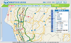
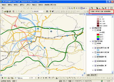
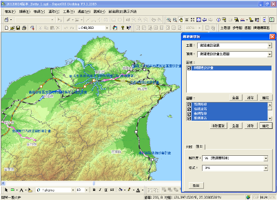
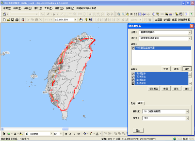
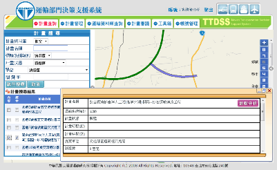
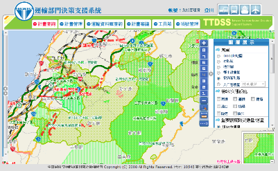
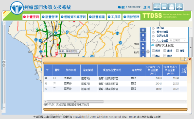
For integrating databases and displaying relevant map of transportation, TTDSS adopted SuperWebGIS 3 to display, operate and analyze map. Besides, SuperGIS Desktop 3 is also applied to customize map content and enrich the map display.

SuperWebGIS, the web map server software, can help enterprises to deliver dynamic maps and GIS data via the Web. With the ubiquitous internet, the spatial data can be shared limitlessly. With SuperWebGIS, commissioners are able to view and manipulate map data on TTDSS directly through internet and browser.

Containing plentiful GIS tools, SuperGIS Desktop 3.1 is a professional GIS platform which provides spatial data and various GIS functions such as relevant data display, editing, management, query and analysis. The administrators of TTDSS can utilize SuperGIS Desktop to modify map content efficiently and facilitate map output with customize function.

 
Results
To display plentiful map information and operate analysis functions, TTDSS consists of desktop GIS and web GIS.

1. Desktop GIS  

To promote and apply TTDSS, improve the map data of railway system and comprehend the distribution relation between transportation systems and the relevant construction plans, this project adopts SuperGIS Desktop 3.1 and adds custom functions. In this project, “Transportation Plan Map Display and Output System” is customized through SuperGIS Desktop 3.1, including theme map, reference map, base map, railroad net. Users are able to switch to different map to view and manipulate according to the map data they need.


Picture 1: GIS Display System Interface of “Railroad Net”

Administrators can add the drawn map to the map data list in the custom interface in this system. Hence, commissioners are able to select the map they need form diverse theme maps, such as basic plan maps, plan draft display map and so on, and select relevant transportation requirement analyzing graphics. To see the display result of theme map, please refer to Picture 2 and Picture 3.
Picture 2: Railroad Development Map of “Railroad Net”
Picture 3: Present Situation Display of Taiwan Railways Administration, MOTC of “Railroad Net”


2. Web GIS
TTDSS website provides users with map viewing function, theme maps switching function and relevant plan query function. Administrators can utilize SuperGIS Desktop to process the collected planning data and build map data for plans, and then overlay the map data on the base map in the system with overlay function. Therefore, decision makers are able to comprehend position of the plan promptly and clearly realize the area that will be influenced by the plan.
 
Picture 4: GIS Display System Interface of “Plan Query”
 
The system website also provides common map navigation functions, like zoom in, zoom out, pan, diverse layers display and switch, etc. By overlaying base maps like topographic map, land-use map and population density map, and distribution map of major districts such as transportation stations, industrial parks and critical land development, commissioners are able to realize the topographic limitation, distribution of peripheral industries and population of each plan district. Additionally, GIS analysis tools in the system can assist commissioners in buffer analyzing, querying population data around the plan district, traffic volume, transportation traffic volume, peripheral construction plan, critical land development and etc.
 
Picture 5: GIS Display System Interface 1 of “Special Region Overlay”
   
Picture 6: GIS Display System Interface 2 of “Special Region Overlay”


With building of TTDSS, commissioners can display diverse theme maps and data on the system interface through internet, and implement various analysis functions to make relevant decision. Utilizing SuperGIS Desktop also assists administrators in creating map file and helps decision makers to output the designed map.. And the efficiency of plan scrutinizing is greatly improved as well.


Related Articles on GISuser:

  • Names on the Land: The Role of the U.S. Board on Geographic NamesNames on the Land: The Role of the U.S. Board on Geographic Names
  • USGS Turns 135: Continues Mission of Science for America USGS Turns 135: Continues Mission of Science for America
  • GIS Application Feature – Location Analysis of Funerary FacilitiesGIS Application Feature – Location Analysis of Funerary Facilities
  • Planning in a 3D World in Prince George’s County, MarylandPlanning in a 3D World in Prince George’s County, Maryland
  • Crowd-Sourcing the National Map: Now a National Effort Crowd-Sourcing the National Map: Now a National Effort
  • Williams & Heintz Map Corp. Uses Avenza PDF Maps to Add Value and Function to PrintWilliams & Heintz Map Corp. Uses Avenza PDF Maps to Add Value and Function to Print

Filed Under: Business Tagged With: Articles, Business, GIS Applications - Taiwan Transportation Decision Support System (TTDSS)


Editor’s Picks

OpenAerialMap - The open collection of aerial imagery

OpenAerialMap – The open collection of aerial imagery

World LiDAR Market is Expected to Reach $921.2 Million by 2022 – Allied Market Research

Map of the Day – TheCeliacScene, Guides for the Gluten Free

HUD and Zillow Hacking for Affordable housing

See More Editor's Picks...

About Editor

Glenn is a geographer and a GIS professional with over 20 years experience in the industry. He's the co-founder of GISuser and several other technology web publications.

Feed

  • RSS


GIS jobs


Recent Features

Digitalization and Simulation at the North Pole

Natural Gas District & GIS-Centric Asset Management

5 Ways Technology Is Affecting The Sharing Economy

Spotlight – Township Canada: Explore Canadian Legal Land Descriptions on a Map

GeoGeeksinCars – The one in “Tippy” the right-hand drive Mitsubishi, at DevSummit

More Posts from this Category

Categories

Recent Posts

  • A treadmill is one of the most popular fitness equipment
  • 3 Things to Help You Become a Software Engineer
  • Esri Announces Winners of the 2022 ArcGIS Online Competition
  • KBC WhatsApp Lottery Winner 2022 List – KBC Head Office Number +19188444477 – KBC Sim Card Lucky Draw 2022
  • Animation explainer for a trading application

RSS Career Tips

  • Four Characteristics of the Best Virtual Employees
  • 8 Questions Employers Should Ask About Coronavirus
  • Jobcase Launches Free Unemployment Resource Center for Workers Impacted by COVID-19
  • Must-Have Gadgets and Technology for the Remote Office Worker
  • Must-Have Gadgets and Technology for the Remote Office Worker


shop for geogeek swag

RSS Tech pubs

  • Top Tips and Tricks: Windows 11
  • The 2022 State of the Data Center Report
  • What is Network Security?

RSS Computers

  • The Essentials of Information Security Kit: Includes a Free PC Security Handbook - 2nd Edition eBook
  • The Idiot's Ultimate Guide to Build Your Own PC
  • Windows... On Speed

RSS HR Tips

  • Measuring and Managing Employee Experience
  • At Work: The 2022 Workplace Trends Report
  • The 2022 Guide To Creating A Great Visitor Experience

RSS Gov Tech

  • The Bipartisan Infrastructure Bill: How you can win more bids
  • How Connected Vehicle Data Can Transform Public Sector Decision-Making
  • Getting started with personalization at scale

RSS UAV news

  • Draganfly Deploys Versatile Situational Assessment Drones to Ukraine
  • Ocean Specialists Inc. Launches “USVs as a Service” Business Line
  • UAS Drone Subsidiary, Duke Robotics’, Sniper Drone showcased at a leading International Airshow in the Asia Pacific Region

RSS Geojobs

  • IT Endpoint Lead
Copyright Spatial Media LLC 2003 - 2015