| Scenario | ||||||||
|
||||||||
| Goals | ||||||||
|
In consideration of ubiquity of smart phone, this project plans to develop an application which is applicable on iOS system. Besides, this application is designed to equip with the functions including tourist destination introduction, map display and itinerary plan. People who want to have a trip in Yilan can download this application and apply it on smart phones. Thus, this application is required to equip with simple manipulation interface, plentiful introduction of tourist destinations, tourism map display function and itinerary plan function. Tourists are able to view the map and query special tourism with famous tourist destinations, food, accommodation, natural experiences and so on in Yilan by downloading and applying this App. For this reason, through this App, the local culture and natural feature of Yilan can also be promoted. |
||||||||
| Solutions | ||||||||
|
In order to promote the features of local tourist attraction and important local customs, Department of Applied Economics & Management of National Yilan University and Yilan Leisure Farming Development Association cooperate to develop “Yilan Travel Guide App” which is applicable on iOS operation system. Integrating with Google Map, Yilan Travel Guide App can display location of the tourist attractions and enables users to plan itinerary routes. Tourists who would like to have a trip to Yilan can apply this application on their smart phones or tablet PC to search tourism information of Yilan over the Internet. Additionally, tourists can spend their holidays in Yilan easily by obtaining the information of nearby tourist attractions and planning the routes with this application. |
||||||||
| Results | ||||||||
|
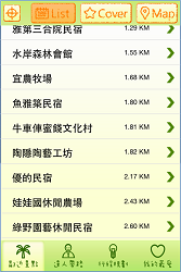
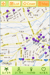
Yilan Travel Guide App is the application applicable on iOS system. The four main themes of this application include “Nearby Tourist Attractions”, “Specialists Lead the Way”, “Itinerary Plan” and “My Favorite.” 1. Nearby Tourist Attractions: By utilizing this function, users are able to query the nearby tourist attractions by locating manually or automatically. The query result shows in a list or with a picture. In addition, users can choose to mark the tourist attractions on the map. |
||||||||
|
||||||||
|
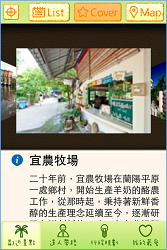
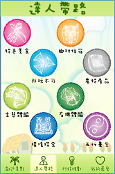
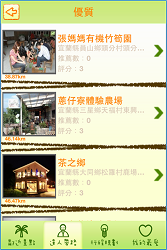
2. Specialists Lead the Way: In this theme, you can tap on the topic that you are interested in, including “Typical Food”, “Accommodation in the Countryside”, “Must Play”, “Specialty Agricultural Products”, “Natural Experience”, “Organic Experience”, “Nature Exploration” and “Five Elements and Health.” Under these topics, the contents are divided into three classes including superior class, recommendation class and popular class. Users can refer to different contents according to the classes which show stores in a list and display the reference distance between the tourist attraction and users’ location. |
||||||||
|
||||||||
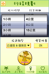
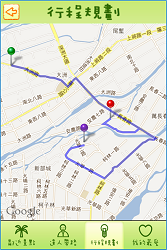
| 3. Itinerary Plan: This theme enables users to set “Travel Time” and “Specify Distance” as condition to search and plan itinerary instantly and flexibly according to trip types and superior recommendation. Please refer to the following pictures: | ||||||||
 |
 |
 |
||||||
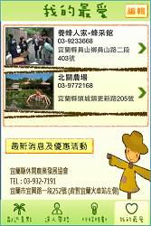
| 4. My Favorite: With “My Favorite”, users are able to save information of tourist attractions and the stores they are interested in for search or viewing next time. | ||||||||
|
Effects: Integrating with information of local tourist attractions and map display, “Yilan Travel Guide App” allows users to use various functions like querying tourist attractions around, searching recommended stores and etc directly and the app does promote features of local customs effectively. Now, this App displays tourist attractions by overlaying base map on Google Map. In days to come, the project plans to adopt SuperGIS Server to integrate map, tourist attractions and information of store location of Yilan, and to publish the relevant information as map services. Therefore, users can query tourism information instantly through browsers, and system administrators are able to update and edit information of tourist attractions and stores on browsers, too. |
||||||||