Supergeo announced that Mobile Cadastral GIS 3.1 (for Android) is officially launched today.
Mobile Cadastral GIS is the application designed for Taiwan cadastral data query and measurement. In order to meet the requirements of field survey, this system with light and quick features integrates with GIS, GPS and digital compass to assist field surveyors in grasping the current position information and cadastral data and in performing task effectively.
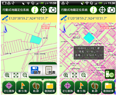
Supporting mobile devices with Android 2.3 or higher version and enhancing query function, the newest Mobile Cadastral GIS 3.1 enables users to query cadastral data and obtain perimeter and area information of the district simultaneously. Therefore, users can recognize the cadastral data more completely. Additionally, field surveyors are able to save query results of cadastral data and export the result as text file (TXT) for data for further application.
Besides Mobile Cadastral GIS which specializes in cadastral investigation, Supergeo also develops SuperSurv for Android users to collect spatial data. Through SuperSurv, field surveyors are allowed to collect and edit point, line, polygon features and the attribute data.
Mobile Cadastral GIS 3.1 now is officially launched in Taiwan. And SuperSurv 3.1 will be launched also this month. To know relevant information of products, please visit Supergeo website: http://www.supergeotek.com/products_MobileGIS.aspx, or contact us with e-mail: staff@supergeotek.com.