GIS user technology news

News, Business, AI, Technology, IOS, Android, Google, Mobile, GIS, Crypto Currency, Economics

  • Advertising & Sponsored Posts
    • Advertising & Sponsored Posts
    • Submit Press
  • PRESS
    • Submit PR
    • Top Press
    • Business
    • Software
    • Hardware
    • UAV News
    • Mobile Technology
  • FEATURES
    • Around the Web
    • Social Media Features
    • EXPERTS & Guests
    • Tips
    • Infographics
  • Blog
  • Events
  • Shop
  • Tradepubs
  • CAREERS
You are here: Home / environment / Louisiana – Seven Years After Hurricanes Katrina And Rita

Louisiana – Seven Years After Hurricanes Katrina And Rita

August 24, 2012 By Editor

Amazing that already we’re headed into September and with that another hurricane season is upon us (I’ve always been somewhat of a hurricane tracker since my days living on the Gulf Coast). Hard to believe that it’s been 7 years since Hurricanes Katrina And Rita and get this, during that time FEMA has spent some $19 billion in rebuilding and recovery in Louisiana State. This financial update has been provide by FEMA.

To assist in rebuilding disaster-damaged public infrastructure, FEMA’s Public Assistance Program has provided approximately $11.5 billion for the restoration of roughly 23,669 Katrina and Rita recovery projects throughout Louisiana. Such FEMA aid has enabled significant impacts across various public sectors, including approximately:

  • $3.9 billion for education and learning facilities
  • $1.1 billion for public safety facilities
  • $5.4 billion for general infrastructure (e.g., roads, transportation, parks and sewerage and water facilities)
  • $1.1 billion for health care facilities

For more info see  the seventh anniversary of hurricanes Katrina and Rita: www.fema.gov/la7year .

See also Hurricane Katrina & Rita Maps, Imagery, weblogs, and more

New Orleans map - vertical profile

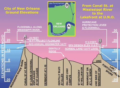
This image is worth 1,000 words! Vertical profile shows where the city of New Orleans is positioned relative to Lake Ponchaltrain and the Mississippi River (Source: flhurricane.com)

Filed Under: environment, FEMA, hurricane, weather

Editor’s Picks

jack dangermond

First Look – Los Angeles Opens the GeoHub – #OpenData for Citizens and Developers

CoreLogic Data Reveals Wildfires Pose Big Risk to Nearly 900,000 Western US Homes in 2015

DigitalGlobe Satellite Captures Dramatic Images of Alberta, Canada Oil Sands wildfire #fmmfire

Tripomatic – Custom Maps Built entirely with OpenSource Mapping Tools

See More Editor's Picks...

About Editor

Glenn is a geographer and a GIS professional with over 20 years experience in the industry. He's the co-founder of GISuser and several other technology web publications.

Recent Industry News

Why Adults Are Trimming Their Routines for Travel and Busy Weeks

June 10, 2026 By GISuser

Top Benefits of AI Video Surveillance for Businesses and Public Spaces

June 5, 2026 By GISuser

How to Choose the Best Office Interior Designers in Delhi for End-to-End Projects

June 3, 2026 By GISuser

Why Bathroom Renovation Services Often Change More Than Just the Bathroom

May 20, 2026 By GISuser

Hot News

State of Data Science Report – AI and Open Source at Work

HERE and AWS Collaborate on New HERE AI Mapping Solutions

Virtual Surveyor Adds Productivity Tools to Mid-Level Smart Drone Surveying Software Plan

Categories

Copyright gletham Communications 2015 - 2026

Go to mobile version