|
|||||||||||||||||||||||||
| Goals | |||||||||||||||||||||||||
|
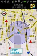
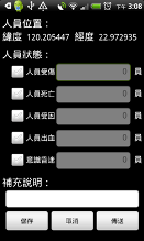
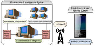
This plan focuses on integrating functions of GPS and GIS on application of smart phones that can be used in evacuating and rescuing, and also aims to decrease disastrous damage and casualties. A smart phone (Android platform) is used as the platform of Geographic Information System for Disaster Evacuation and Rescue applying. Besides, disaster evacuation and rescue spatial information system contains function of instant GPS coordinate positioning on local machine and function of connecting to Web GIS Network Server on Cloud. Additionally, working with GIS Network Server, this application provides users with disastrous situation and instant network analysis for taking real-time traffic information such as road and bridge damage or prevention and rescue information from related sections into consideration. Therefore, the result of network analysis can be published in form of layers on map service on mobile application for people to utilize. |
|||||||||||||||||||||||||
| Solutions | |||||||||||||||||||||||||
|
Features of “Geographic Information System for Disaster Evacuation and Rescue”: SuperGIS Network Server is adopted as network analysis server. It provides diverse network analysis methods which contain “Short Path”, “Superior Route Planning”, “Closest Facilities”, “Service Area”, “Minimum Spanning Tree”, “Center Problem”, “Median Problem” and “Vehicle Routing Problem”(VRP).
|
|||||||||||||||||||||||||
 |
|||||||||||||||||||||||||
| Results | |||||||||||||||||||||||||
|
|||||||||||||||||||||||||