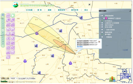
SuperGIS Server, developed by SuperGeo, has been successfully applied to “Yilan Pollution Control GIS.”
To effectively manage and control the pollution data and distribution in Yilan, Department of Environmental Protection Yilan adopts SuperGIS Server to build “Yilan Pollution Control GIS.” The website collects the related layer data for the staff and provides spatial data display, such as marine pollution simulation display, air pollution simulation display, and GIS manipulation, like add annotations on the map. As to the back-end of the website, the staff in Department of Environmental Protection Yilan can keep updating the data through the data management function to provide the colleagues with the latest and most timely information.
SuperGIS Server enables enterprises to build, manage, integrate, and publish various GIS services within the centralized server structure. Therefore, with the Internet, the spatial data, imagery, and GIS functions can be published as GIS services on desktop, mobile, and web applications. Meanwhile, the ideal enterprise workflow can be built, and the enterprises’ capability of decision-making and productivity can be greatly enhanced. SuperGIS Server also offers multiple Web APIs, such as JavaScript, Silverlight, and Flex, and helps developers to customize their own website. For more product information, please visit SuperGeo Website (http://www.supergeotek.com), or email us(staff@supergeotek.com).