GIS user technology news

News, Business, AI, Technology, IOS, Android, Google, Mobile, GIS, Crypto Currency, Economics

  • Advertising & Sponsored Posts
    • Advertising & Sponsored Posts
    • Submit Press
  • PRESS
    • Submit PR
    • Top Press
    • Business
    • Software
    • Hardware
    • UAV News
    • Mobile Technology
  • FEATURES
    • Around the Web
    • Social Media Features
    • EXPERTS & Guests
    • Tips
    • Infographics
  • Blog
  • Events
  • Shop
  • Tradepubs
  • CAREERS
You are here: Home / *FEATURES / THE EDITOR / 10 cool things about GeoCommons 2.0

10 cool things about GeoCommons 2.0

June 6, 2011 By Editor

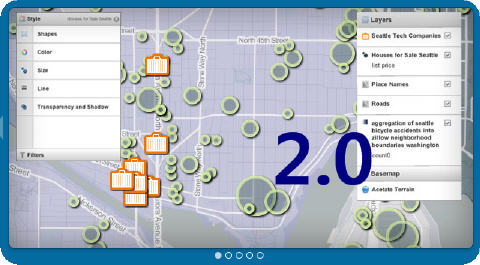
You may have heard or read recently that the GeoIQ team has announced R2 of Geocommons – Enter GeoCommons 2.0. Personally, I’m stoked about the faster service, sweet cartographic capabilities, easy share, and enhanced analysis capabilities!

From the GeoCommons team… GeoCommons, an open repository of data and maps, launched version 2.0 this week, which is more feature-rich and robust than the first. Two of the major updates have to do with the fast-changing data landscape: amount of data and browser technology.

This major update boast loads of new features and functionality. 10 things of interest to the new user include:

  1. A more robust visualization engine – you can now visualize tens of thousands of points in seconds or push the limits with hundreds of thousands of points.  You are no longer bound by just static map tiles when working with big data sets, plus you can animate and filter all of it on the fly.
  2. Cross-browser platform Support – view your maps anywhere from IE to your iPad.  We’ve added support for HTML5 and Flash.
  3. Custom Icon Creator – personalize your maps with any icons of your choosing.  Just copy and paste an image URL to create instant custom icons.  These icons can also be used for creating thematic maps where they are sized by their value.
  4. Multi-attribute filtering – add several attributes to your map and easily query using both numeric and text data attributes.
  5. Easier Data Editing – you can now edit, filter and query your data within the GeoCommons workflow. No more editing in Excel and uploading multiple versions of your data.
  6. Revamped Temporal analysis – See huge data sets smoothly animate over time with our improved time slider that aggregates and bins your time-based data automatically.
  7. Easy-to-use, advanced spatial analytics that enterprises and agencies can utilize to answer mission-critical questions right away.
  8. No desktop software or technical course required.
  9. Select among numerous analyses such as filtering, buffers, spatial aggregation and predictive analysis.
  10. Analysis now runs asynchronously meaning you can run bigger analysis functions and not lock up your browser.  Keep working and we’ll notify you when the analysis is done.

You can read all about the latest update on the GeoCommons Blog – see details here
For the developer, check out what Andrew Turner has shared about the latest updates on the GeoIQ Dev Blog. Finally, the team has also shared a tour of the new release HERE

Test drive GeoCommons for yourself at http://geocommons.com/
geocommons

Related Items:

1. Non-Techies Can Now Harness SoLoMo Data Through GeoIQ’s New GeoCommons 2.0
(News/GIS, Geo Tech Software)
…s platform.   A subset of these new capabilities was made available yesterday through the launch of GeoCommons 2.0, the newest version of the community site powered by GeoIQ.  See a to…
01 June 2011

2. GeoIQ Powers the World Bank’s Mapping for Results Initiative
(News/Business)
… of detail. GeoIQ’s geospatial platform, a version of which is available for free and public use through GeoCommons, enables easy collaborative sharing of data, visualization and analysis. The Ge…
25 April 2011

3. Andrew Turner, CTO of GeoIQ Receives 2011 SmartCTO Award
(News/Business)
…l market. After playing a key role in building both the GeoIQ location intelligence enterprise engine and the GeoCommons community site, Andrew used his innovative thinking and leadership capabilities…
11 April 2011

4. AGIO and Open Data, GIS data in time of disaster, and Putting Arkansas on the Map
(Experts/Learon Dalby )
…ers within other agencies that may need the data if disaster strikes.) 3. Data is sent and loaded into GeoCommons once a year (http://goo.gl/2hFlN). (It does not cost the AGIO anything, and it …
23 March 2011

5. FortiusOne Rebrands as GeoIQ
(News/Business)
…t for geospatial data exploration, visualization and analysis.  GeoIQ also powers the over 23,000 member GeoCommons community where anyone can find, use and share data and maps.  More…
17 March 2011


Filed Under: THE EDITOR Tagged With: 10 cool things about GeoCommons 2.0, editor, Experts, Glenn Letham, gletham

About Editor

Glenn is a geographer and a GIS professional with over 20 years experience in the industry. He's the co-founder of GISuser and several other technology web publications.

Top Press

The Global Expansion of Aueshah: A New Era of High Jewelry

April 11, 2026 By GISuser

KARACHI, PAKISTAN. The international luxury market is experiencing a profound shift. Consumers are increasingly rejecting mass-produced goods in favor of rarity, authenticity, and emotional depth. … [Read More...]

State of Data Science Report – AI and Open Source at Work

September 10, 2025 By GISuser

AI and Open Source at Work … [Read More...]

Topcon Announces Landmark Expansion of Topnet Live Network Across USA

January 26, 2025 By GISuser

LIVERMORE, Calif.---Topcon Positioning Systems has announced a significant expansion of its Topnet Live reference station network, introducing 200 new geodetic stations strategically positioned across … [Read More...]

Space Flight Laboratory (SFL) Announces Launch and Deployment of NorSat-4 Maritime Monitoring Microsatellite

January 19, 2025 By GISuser

Seventh Satellite Developed by SFL for Norway … [Read More...]

HERE and BMW Group extend partnership on AI-powered mapping system

January 8, 2025 By GISuser

HERE and BMW Group extend partnership on AI-powered mapping system for automated driving and enhanced road safety … [Read More...]

Everest Base Camp Helicopter Tour, Helicopter Return Trek, and Manaslu Circuit Trek: Which Nepal Adventure Is Right for You?

November 6, 2026 By GISuser

Almost everyone planning a Nepal trip runs into the same wall. You want the big mountains, you have a fixed number of days, and every itinerary you read seems to promise something … [Read More...]

SFL Missions Inc. Confirms Successful Deployment of Six HawkEye 360 Radio Frequency Detection Satellites with Advanced Capabilities

October 27, 2026 By GISuser

MĀHIA, New Zealand, 26 October 2026 – SFL Missions Inc. today confirmed the successful deployment of six radio frequency (RF) detection and geolocation satellites for HawkEye 360 … [Read More...]

Canadian-Built RoadEng 12 Uses AI to Find the Best Location for New Resource and Rural Roads

October 17, 2026 By GISuser

Vancouver, BC, Canada, October 15, 2026 – North Vancouver-based Softree Technical Systems today released RoadEng Version 12, used in more than 75 countries to locate and design … [Read More...]

Beyond the Map: How AI Image and Video Generation Is Changing Geospatial Communication

October 14, 2026 By GISuser

Ask anyone who has shipped a GIS project what the hardest part was, and the answer is rarely the spatial analysis. It is almost always the communication. A site suitability … [Read More...]

From Maternity to Everyday Wear: Building a Wardrobe That Grows With You

October 14, 2026 By GISuser

When I think about maternity clothing, I feel the biggest mistake is buying too many things at once. During pregnancy, your body keeps changing, and something that fits well today … [Read More...]

Copyright gletham Communications 2015 - 2026

Go to mobile version