


- Shorelines are color-coded to indicate their sensitivity to oiling.
- Sensitive biological resources, such as seabird colonies and marine mammal hauling grounds, are depicted by special symbols on the maps.
- ESI maps also show sensitive human-use resources, such as water intakes, marinas, and swimming beaches.
Project scientists have created collections of ESI maps, called ESI atlases, for most coastal areas in the US, including Alaska, Hawaii, the Great Lakes, and the Trust Territories. Each atlas includes
- a set of maps.
- pages of additional information about the biological resources and other features shown on the maps.
To learn more about ESI maps and the information they contain, view a sample map and other products, try an online exercise, or view more technical ESI references, including the metadata for many ESI atlases.
ESI maps are available in print and electronic formats. Our Product Ordering page and list of available ESI atlases show which atlases are available, in which formats.
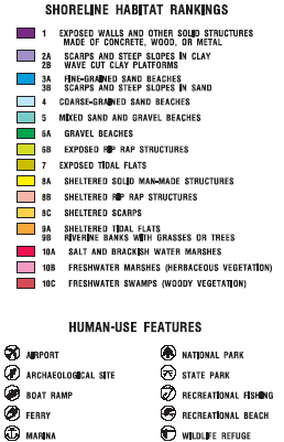

A sample legend from an ESI Map from Alabama
Project Status
Starting in 1995 with the outer coast of California, ESI project members began using a Geographic Information System (GIS) to produce updated ESI maps that are higher in quality and can be more readily reproduced. Using a GIS also has made it possible to distribute ESI information in a variety of digital formats, as well as paper maps. Each of NOAA’s ESI mapping efforts is a cooperative effort with the primary State response agency, other State and Federal agencies, and industry.
For more information about ESI mapping review the ESI factsheet (87K PDF file).
http://oceanservice.noaa.gov/mapfinder/products/esi/welcome.html


