GIS user technology news

News, Business, AI, Technology, IOS, Android, Google, Mobile, GIS, Crypto Currency, Economics

  • Advertising & Sponsored Posts
    • Advertising & Sponsored Posts
    • Submit Press
  • PRESS
    • Submit PR
    • Top Press
    • Business
    • Software
    • Hardware
    • UAV News
    • Mobile Technology
  • FEATURES
    • Around the Web
    • Social Media Features
    • EXPERTS & Guests
    • Tips
    • Infographics
  • Blog
  • Events
  • Shop
  • Tradepubs
  • CAREERS
You are here: Home / * PRESS / Mobile / SuperSurv 3.2 Supports iOS 8 and Enhances GPS Display

SuperSurv 3.2 Supports iOS 8 and Enhances GPS Display

December 2, 2014 By GISuser

SuperSurv (iOS) 3.2, the field data collecting app for iPhone and iPad users, now fully supports iOS 8 and enhances GPS display with optimal user experiences.

Developed by Supergeo, SuperSurv is an efficient mobile GIS app for field data collection on iOS and Android platforms. Integrating with GIS and GPS technologies, SuperSurv provides functions like Map Display, Query, Measure, etc., and supports to overlay OpenStreetMap as the basemap. Also, users may capture point, line and polygon features and attribute data, and save the data as SHP or GEO format in both offline and online modes.

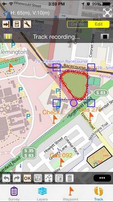
The latest SuperSurv 3.2 supports iOS 8 and improves manipulation interface. In the newest update, horizontal and vertical accuracy of current GPS signal are supported to display straightforwardly on GPS status bar to assist users in comprehending current accuracy. This can be a significant reference for surveyors to decide the way and timing to collect data.

Supergeo also disclosed that, in coming update, SuperSurv will support more raster formats, including MrSID, and JPEG200, giving users more basemap support. Meanwhile, SuperSurv will enhance its capability in data collection and attribute querying so that surveyors can collect features by GPS more efficiently, and preview photo and video within attribute data.

SuperSurv trial

App Store:
https://itunes.apple.com/us/app/supersurv/id734191604?mt=8

Play Store:
https://play.google.com/store/apps/details?id=com.supergeo.asd.supersurvlite.SuperSurv

Filed Under: Mobile, Software, Top Press Tagged With: SuperSurv

Editor’s Picks

FireWhat? Mobile GIS Lab, Emergency Incident Mapping and HP Mobile Workstations

Tripomatic – Custom Maps Built entirely with OpenSource Mapping Tools

#DevSummit Video – A First Look at Drone2Map for ArcGIS

Global Earthquake Numbers on Par for 2015

See More Editor's Picks...

Recent Industry News

The Future of Competitive Gaming: Why DMA Technology is the Ultimate Performance Edge

June 24, 2026 By GISuser

Milwaukee M18FHZ-0 Hackzall Reciprocating Saw – For hardcore cutting in a compact size

June 19, 2026 By GISuser

How Enterprises Are Using AI to Automate 80% of Customer Interactions With Voice Agents

June 16, 2026 By GISuser

Why On Cloud Shoes Are Worth the Price in Mexico

June 16, 2026 By GISuser

Hot News

State of Data Science Report – AI and Open Source at Work

HERE and AWS Collaborate on New HERE AI Mapping Solutions

Virtual Surveyor Adds Productivity Tools to Mid-Level Smart Drone Surveying Software Plan

Categories

Copyright gletham Communications 2015 - 2026

Go to mobile version