GIS user technology news

News, Business, AI, Technology, IOS, Android, Google, Mobile, GIS, Crypto Currency, Economics

  • Advertising & Sponsored Posts
    • Advertising & Sponsored Posts
    • Submit Press
  • PRESS
    • Submit PR
    • Top Press
    • Business
    • Software
    • Hardware
    • UAV News
    • Mobile Technology
  • FEATURES
    • Around the Web
    • Social Media Features
    • EXPERTS & Guests
    • Tips
    • Infographics
  • Blog
  • Events
  • Shop
  • Tradepubs
  • CAREERS
You are here: Home / Archives for Webinar

Webinar – Flights Into the Past: Archaeological Prospection Using Lidar

October 15, 2019 By GISuser

lidar webinar series

What can we learn from the patterns of past civilizations? Today’s researchers are harnessing the power of lidar to map ancient landscapes—landscapes that can help us design, plan, organize, and maintain systems that are resilient to cultural and ecological change.

Filed Under: Top Text Lead Story, Webinars Tagged With: event, Webinar

10 Tips to Get the Most Out of Your Drone Data

September 23, 2019 By GISuser

10 Tips to Get the Most Out of Your Drone Data

Drones and the data they generate are transforming industries. With the rapid rate of innovation and increased adoption, users need to continue learning to keep pace with the industry.

Filed Under: Top Press, UAV/UAS, Webinars Tagged With: UAV, Webinar

Webinar / Video – The Modern Drone Mapping Project – Choosing the Right Approach

July 18, 2019 By GISuser

Didn’t catch the live webinar streamed from the ESRIUC? No problem, enjoy this video archive – The Modern Drone Mapping Project – Choosing the Right Approach, presented by Woolpert as part of the LiDAR Magazine webinar series.

Filed Under: Hot Webinars, LiDAR, Top Text Lead Story, UAV/UAS, VIDEOS, Webinars Tagged With: 3D, lidar, UAV, Video, Webinar, Woolpert

Webinar – Location Matters: Introducing Location Tracking for ArcGIS

July 17, 2019 By GISuser

Here’s a tip about a webinar being presented by Esri Canada.

Filed Under: Webinars Tagged With: arcgis, ESRI, Webinar

GIS / GeoTech Industry Events Roundup (May 2019)

May 29, 2019 By GISuser

Welcome to our GISuser, Geotech industry news roundup. Here you’ll find pointers and tips for events, meetups, webinars and other Geo events taking place in the near future. Do you have a Geo event to share? Tell the editor about it!

Filed Under: Events, Featured Event, Tips Tagged With: conference, events, Webinar

Webinar: How Municipalities Are Using Analytics to Build Better Maps

May 8, 2019 By GISuser

Want to see what your visitors are doing on your map? Stop guessing if your map visitors are reaching their goals by measuring their experience. Municipalities around North America are using Maptiks web map analytics.

Filed Under: Top Text Lead Story, Webinars Tagged With: analytics, maptiks, sparkgeo, Webinar

Golden Software Announces Time Series Data Visualization Webinar

April 2, 2019 By GISuser

This time-series raster map indicates daily peak volumetric flow rates of the Colorado River at Lees Ferry, AZ over approximately the last 100 years.

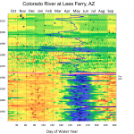
GOLDEN, Colorado, 2 April 2019 – Golden Software, a developer of affordable scientific graphics software, will present a free webinar to demonstrate how the Surfer® 2D and 3D mapping package can be used to easily and quickly visualize changes in data points over time for analysis of patterns, trends, and anomalies.

Filed Under: Events, Top Press, Webinars Tagged With: Webinar

Webinar – What’s New in LP360

November 14, 2018 By GISuser

Webinar - What's New in LP360

Whether from airborne LIDAR or drone collected imagery, 3D point clouds have become a critical element in mapping. LP360, an advanced desktop software, makes easy work of extracting information and deriving products from point clouds in standalone or ArcGIS environment.

Filed Under: Hot Webinars, LiDAR, Top Text Lead Story, Webinars Tagged With: lidar, Webinar

GeoDev Webinar Tip – Vector Tile Styling

July 24, 2018 By Editor

A webinar tip for you – July 25, 2018

Filed Under: Developer, Events, Webinars Tagged With: Webinar

Event / Webinar Tip – security.manager – Stay in control of your ArcGIS Services

June 20, 2018 By GISuser

security.manager – ArcGIS Edition: Revolutionize how you publish content via ArcGIS

Filed Under: Business, Events, Webinars Tagged With: Webinar

« Previous Page
Next Page »

Recent Industry News

The Future of Competitive Gaming: Why DMA Technology is the Ultimate Performance Edge

June 24, 2026 By GISuser

Milwaukee M18FHZ-0 Hackzall Reciprocating Saw – For hardcore cutting in a compact size

June 19, 2026 By GISuser

How Enterprises Are Using AI to Automate 80% of Customer Interactions With Voice Agents

June 16, 2026 By GISuser

Why On Cloud Shoes Are Worth the Price in Mexico

June 16, 2026 By GISuser

Hot News

State of Data Science Report – AI and Open Source at Work

HERE and AWS Collaborate on New HERE AI Mapping Solutions

Virtual Surveyor Adds Productivity Tools to Mid-Level Smart Drone Surveying Software Plan

Categories

Copyright gletham Communications 2015 - 2026

Go to mobile version