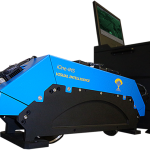
Mexico City-based FYSPSA Purchases iOne Stereo 12 MS Digital Aerial Sensor for High-Precision Mapping and Geoimaging Missions
Visual Intelligence’s iOne Sensor Systems Solutions Now Available with Industry’s Leading SOMAG GSM
Visual Intelligence’s iOne Sensor Systems Solutions Now Available with Industry’s Leading SOMAG GSM 3000 Gyro Stabilization Mount – Visual Intelligence and SOMAG AG Jena Establish Strategic Alliance to Jointly Synergize the Enabling of iOne Multipurpose Sensors
Visual Intelligence Redefines the Capabilities of Medium Format Aerial Cameras with the iOne M+
Visual Intelligence Redefines the Capabilities of Medium Format Aerial Cameras with the iOne M+ Medium Format Digital Aerial Sensor — Designed to be Flown with or without LiDAR, the iOne M+ is the Largest and Most Precise Medium Format Sensor on the Market
Hellas Sat & Arabsat Joining Forces at CABSAT in Dubai March 11-13th
With Hellas Sat now being a Member of the Arabsat Group, the two companies will take advantage of the commercial synergies and have their first joint stand at CABSAT. CABSAT will allow Hellas Sat and Arabsat to strengthen their commercial presence not only in their respective core markets of Europe and Middle East, but […]
Tournament Earth 2014: Which Image Will Win It?
Thirty-two have been called, but which will be chosen? NASA’s Earth Observatory is hosting the second annual Tournament Earth, a reader-driven competition to choose the previous year’s top NASA image of our planet. The tournament starts March 3 and ends on April 7, with five rounds of voting spread across five weeks. Images in the […]
Visual Intelligence Releases iOne Sensor Reconfiguration Kit for the iOne Stereo, n-Oblique/3D
Visual Intelligence Releases iOne Sensor Reconfiguration Kit for the iOne Stereo, n-Oblique/3D and IMS Geoimaging Sensor Systems Solutions – Flexible, Scalable iOne Solutions Can Now Be Reconfigured in the Field—Providing Three Sensors for Less than the Price of One Traditional, Monolithic Digital Airborne Camera
Ball Aerospace Completes Integration of WorldView-3 Spacecraft
Remote-sensing satellite for DigitalGlobe prepares for thermal vacuum testing
Arcturus UAV and Urban Robotics Fly 3-D Imager
ROHNERT PARK, Calif., Jan. 24, 2014 — The GeoDragon sensor system has now been integrated and flown on an Arcturus UAV T-20 Tier II unmanned aerial vehicle. The sensor system is enclosed in a wing-mounted pod and is capable of high resolution 2-D and 3-D image capture. The sensor was designed by Urban Robotics in Portland, Oregon. The […]
AeroGRID Provides WMS Access to 4.6 million km² of European High Resolution High Accuracy Orthophoto
Paris, France 7th January 2014 – In 2013 AeroGRID added 1.5 million km² of high resolution aerial orthophotos of Europe to its WMS servers and now provides access to 25 countries and 4.6 million km². The comprehensive metadata with detailed accuracy specifications mean that users can be confident the imagery will provide a sound basis […]
Astrium and GeoNorth sign first ever multi-satellite Direct Receiving Station
16 December 2013 – Astrium, the world’s second largest space company, signed with GeoNorth, LLC for the first multi-mission Direct Receiving Station (DRS), with a unique offering of both high-resolution and very high-resolution optical and radar satellite imagery capabilities. This new contract brings to nearly 40 the number of stations in the Astrium Services DRS […]