Copernicus (formerly known as GMES, Global Monitoring for Environment and Security) is the European Union’s Earth observation and monitoring programme, a user driven programme, building on the existing national and European capacities and establishing new infrastructure and services. Copernicus consists of a complex set of systems which collect data from multiple sources: Earth observation satellites, […]
Airbus Defence and Space signs ESA contract for high-preci sion Earth observatio n instrument
Airbus Defence and Space signs ESA contract for high-precision Earth observation instrument · Sentinel-5 spectrometer will monitor the composition of the atmosphere for the Copernicus programme · Contract worth €144 million Airbus Defence and Space, the world’s second largest space company, will be the European Space Agency’s (ESA’s) prime contractor for the development and […]
BATHYMETRY FROM SPACE: GAF’S INNOVATIVE STEREO APPROACH
GAF AG has developed and successfully demonstrated a new innovative approach for deriving bathymetry from space. With this method, GAF can generate bathymetric maps covering large areas by simultaneously using differential spectral attenuation and stereo-information from satellite imagery. The approach only requires the use of satellite stereo imagery with precise ephemeris data and is therefore […]
Visual Intelligence Completes Customer Agreement with FYSPSA for iOne Digital Aerial Sensor
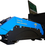
Mexico City-based FYSPSA Purchases iOne Stereo 12 MS Digital Aerial Sensor for High-Precision Mapping and Geoimaging Missions
Visual Intelligence’s iOne Sensor Systems Solutions Now Available with Industry’s Leading SOMAG GSM
Visual Intelligence’s iOne Sensor Systems Solutions Now Available with Industry’s Leading SOMAG GSM 3000 Gyro Stabilization Mount – Visual Intelligence and SOMAG AG Jena Establish Strategic Alliance to Jointly Synergize the Enabling of iOne Multipurpose Sensors
Visual Intelligence Redefines the Capabilities of Medium Format Aerial Cameras with the iOne M+
Visual Intelligence Redefines the Capabilities of Medium Format Aerial Cameras with the iOne M+ Medium Format Digital Aerial Sensor — Designed to be Flown with or without LiDAR, the iOne M+ is the Largest and Most Precise Medium Format Sensor on the Market
Hellas Sat & Arabsat Joining Forces at CABSAT in Dubai March 11-13th
With Hellas Sat now being a Member of the Arabsat Group, the two companies will take advantage of the commercial synergies and have their first joint stand at CABSAT. CABSAT will allow Hellas Sat and Arabsat to strengthen their commercial presence not only in their respective core markets of Europe and Middle East, but […]
Tournament Earth 2014: Which Image Will Win It?
Thirty-two have been called, but which will be chosen? NASA’s Earth Observatory is hosting the second annual Tournament Earth, a reader-driven competition to choose the previous year’s top NASA image of our planet. The tournament starts March 3 and ends on April 7, with five rounds of voting spread across five weeks. Images in the […]
Visual Intelligence Releases iOne Sensor Reconfiguration Kit for the iOne Stereo, n-Oblique/3D
Visual Intelligence Releases iOne Sensor Reconfiguration Kit for the iOne Stereo, n-Oblique/3D and IMS Geoimaging Sensor Systems Solutions – Flexible, Scalable iOne Solutions Can Now Be Reconfigured in the Field—Providing Three Sensors for Less than the Price of One Traditional, Monolithic Digital Airborne Camera
First UltraCam Hawk in US Purchased by Bergman Photograph ic
Graz, Austria — February 5, 2014 — Bergman Photographic Services has contracted with Microsoft’s UltraCam business unit and subsidiary to purchase an UltraCam Hawk digital aerial camera system. Bergman Photographic has been an adopter of the UltraCam product line since its purchase in 2009 of the first UltraCamL to be based in the US Pacific […]