GIS user technology news

News, Business, AI, Technology, IOS, Android, Google, Mobile, GIS, Crypto Currency, Economics

  • Advertising & Sponsored Posts
    • Advertising & Sponsored Posts
    • Submit Press
  • PRESS
    • Submit PR
    • Top Press
    • Business
    • Software
    • Hardware
    • UAV News
    • Mobile Technology
  • FEATURES
    • Around the Web
    • Social Media Features
    • EXPERTS & Guests
    • Tips
    • Infographics
  • Blog
  • Events
  • Shop
  • Tradepubs
  • CAREERS
You are here: Home / * PRESS / Environment / Schmidt Ocean Institute Maps One Million Square Kilometers of Seafloor

Schmidt Ocean Institute Maps One Million Square Kilometers of Seafloor

December 18, 2019 By GISuser

Schmidt Ocean Institute Maps One Million Square Kilometers of Seafloor and Joins Monumental Mapping Initiative

Schmidt Ocean Institute, a non-profit dedicated to advancing the world’s understanding of the ocean with cutting-edge science, reached a major milestone mapping more than one million square kilometers of ocean floor, and simultaneously made a commitment to The Nippon Foundation-GEBCO Seabed 2030 Project to help create a global map of the ocean floor.

LONDON, Dec. 9, 2019 /PRNewswire/ — Schmidt Ocean Institute has come together with The Nippon Foundation-GEBCO Seabed 2030 Project for the joint signing of a Memorandum of Understanding to share all of its collected mapping data with the project. According to the Seabed 2030 Project, about 32 million square kilometers or 15% of the ocean has been mapped. The million square kilometer milestone is a big one for Schmidt Ocean, accounting for 3% of this mapping contribution and the discovery of 14 new underwater features.

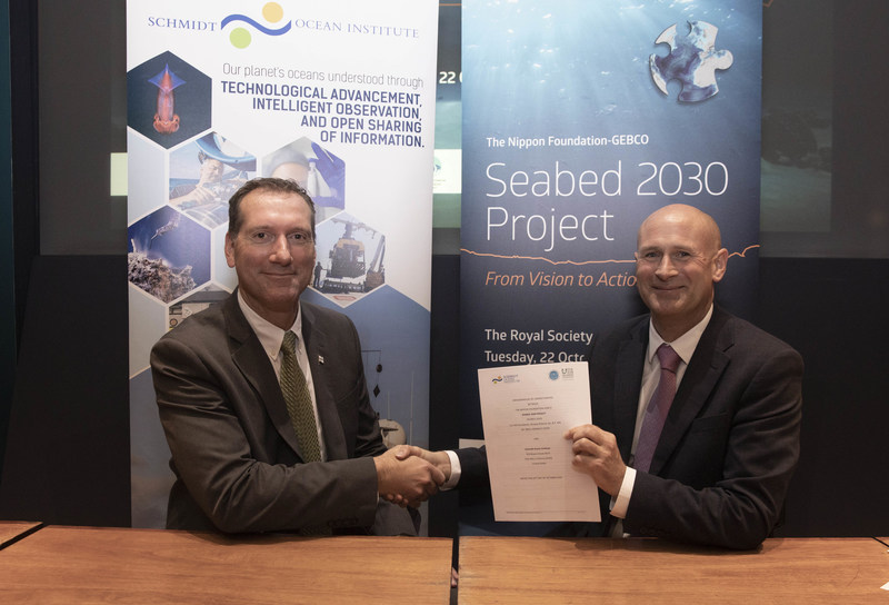
R/V Falkor has hit a major milestone mapping more than a million square kilometers of ocean floor and simultaneously making a commitment to the The Nippon Foundation-GEBCO Seabed 2030 Project. Seabed 2030 is a global program aimed at creating a super-detailed map of the entire ocean floor by the year 2030. Schmidt Ocean Institute has focused its mapping on remote regions that require high-resolution seafloor imagery to contribute to expansion or additional protections.
Schmidt Ocean Institute Director of Operations Eric King and The Nippon Foundation-GEBCO Seabed 2030 former Acting Director Graham Allen sign the Seabed 2030 Memorandum of Understanding at the Royal Society in London. Image credit: John Cobb/The Nippon Foundation-GEBCO Seabed 2030 Project.

The groups met at the Royal Society, making Schmidt Ocean one of more than 100 organizations to formally support the initiative. Seabed 2030 is a global initiative aimed at creating a detailed, freely available map of the entire ocean floor by the year 2030. GEBCO (General Bathymetric Chart of the Oceans) is the only organization with a mandate to map the ocean floor.

The organizations are working together to achieve high-resolution mapping that is needed in ocean science. In fact, Seabed 2030 is working closely with the recently announced United Nations Decade of Ocean Science initiative that will begin in 2021. “While mapping the entire ocean floor by 2030 seems like a daunting task, we are making headway thanks to the commitment of commercial, scientific and private vessels, including Schmidt Ocean Institute’s R/V Falkor,” said Seabed 2030 Director Jamie McMichael-Phillips.

Schmidt Ocean Institute brings unique value due to its focus on mapping remote regions that require high-resolution seafloor imagery to contribute to expansion or additional protections. Some of its large mapping efforts have focused on the Papahanaumokuakea Marine National Monument in Hawaii, Cocos Island National Park in Costa Rica, and the Phoenix Islands Protected Area in Kiribati.

“Most people don’t think about the bottom of the ocean. When you look at a map, the ocean is portrayed as flat blue with very few features,” said Schmidt Ocean Institute co-founder Wendy Schmidt. “However, this couldn’t be further from what the ocean floor looks like. Picture huge mountains and canyons, exotic hydrothermal vent forests and unique conditions that mimic other planets. There are still so many things we do not know about the topography or the ecosystems that cover the largest part of our earth.”

Gaining visuals of the ocean floor is critical to unlocking a better understanding of the world’s oceans.  There are predicted to be millions of unknown species whose function and contribution to ocean and human health is still unknown. High resolution maps guide scientists to these unexplored areas where further study and sampling can take place. “A high-resolution map of our seafloor will be an invaluable tool in protecting our oceans,” says Schmidt.

“What is important is that these maps are open-source and available to anyone from any country,” said Schmidt Ocean Operations Director Eric King. “This effort can only be achieved through cooperation and collaboration. Everyone who travels, explores, or uses our oceans has a role to play and can benefit from this initiative.”

Schmidt Ocean Institute will provide mapping data, but has also setup dedicated mapping expeditions like “Mapping the Gaps” with its own research vessel Falkor, to help fill in the holes in previously collected mapping data. “Our organization is happy to see our data be a part of this collective initiative,” says King. “I look forward to a day when we can see an image of a fully mapped ocean.”

View a video about R/V Falkor’s mapping program & the Seabed 2030 initiative here

Related Links

http://www.schmidtocean.org

Filed Under: Business, Environment

Top Press

The Global Expansion of Aueshah: A New Era of High Jewelry

April 11, 2026 By GISuser

KARACHI, PAKISTAN. The international luxury market is experiencing a profound shift. Consumers are increasingly rejecting mass-produced goods in favor of rarity, authenticity, and emotional depth. … [Read More...]

State of Data Science Report – AI and Open Source at Work

September 10, 2025 By GISuser

AI and Open Source at Work … [Read More...]

Topcon Announces Landmark Expansion of Topnet Live Network Across USA

January 26, 2025 By GISuser

LIVERMORE, Calif.---Topcon Positioning Systems has announced a significant expansion of its Topnet Live reference station network, introducing 200 new geodetic stations strategically positioned across … [Read More...]

Space Flight Laboratory (SFL) Announces Launch and Deployment of NorSat-4 Maritime Monitoring Microsatellite

January 19, 2025 By GISuser

Seventh Satellite Developed by SFL for Norway … [Read More...]

HERE and BMW Group extend partnership on AI-powered mapping system

January 8, 2025 By GISuser

HERE and BMW Group extend partnership on AI-powered mapping system for automated driving and enhanced road safety … [Read More...]

Everest Base Camp Helicopter Tour, Helicopter Return Trek, and Manaslu Circuit Trek: Which Nepal Adventure Is Right for You?

November 6, 2026 By GISuser

Almost everyone planning a Nepal trip runs into the same wall. You want the big mountains, you have a fixed number of days, and every itinerary you read seems to promise something … [Read More...]

SFL Missions Inc. Confirms Successful Deployment of Six HawkEye 360 Radio Frequency Detection Satellites with Advanced Capabilities

October 27, 2026 By GISuser

MĀHIA, New Zealand, 26 October 2026 – SFL Missions Inc. today confirmed the successful deployment of six radio frequency (RF) detection and geolocation satellites for HawkEye 360 … [Read More...]

Canadian-Built RoadEng 12 Uses AI to Find the Best Location for New Resource and Rural Roads

October 17, 2026 By GISuser

Vancouver, BC, Canada, October 15, 2026 – North Vancouver-based Softree Technical Systems today released RoadEng Version 12, used in more than 75 countries to locate and design … [Read More...]

Beyond the Map: How AI Image and Video Generation Is Changing Geospatial Communication

October 14, 2026 By GISuser

Ask anyone who has shipped a GIS project what the hardest part was, and the answer is rarely the spatial analysis. It is almost always the communication. A site suitability … [Read More...]

From Maternity to Everyday Wear: Building a Wardrobe That Grows With You

October 14, 2026 By GISuser

When I think about maternity clothing, I feel the biggest mistake is buying too many things at once. During pregnancy, your body keeps changing, and something that fits well today … [Read More...]

Copyright gletham Communications 2015 - 2026

Go to mobile version