GIS user technology news

News, Business, AI, Technology, IOS, Android, Google, Mobile, GIS, Crypto Currency, Economics

  • Advertising & Sponsored Posts
    • Advertising & Sponsored Posts
    • Submit Press
  • PRESS
    • Submit PR
    • Top Press
    • Business
    • Software
    • Hardware
    • UAV News
    • Mobile Technology
  • FEATURES
    • Around the Web
    • Social Media Features
    • EXPERTS & Guests
    • Tips
    • Infographics
  • Blog
  • Events
  • Shop
  • Tradepubs
  • CAREERS
You are here: Home / * PRESS / Hardware / Seabotics Completes First HYCAT Production Run

Seabotics Completes First HYCAT Production Run

January 15, 2019 By GISuser

Man-Portable Autonomous Surface Vehicle for Hydrographic Surveys was developed in partnership with Xylem Inc.
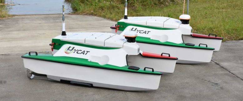
STUART, Fla., January 15, 2018 — SeaRobotics Corporation (SeaRobotics) today announced that it has completed the first production run of the HYCAT Autonomous Surface Vehicle (ASV) in partnership with Xylem, USA. This unique ASV, offered by both Xylem and SeaRobotics, provides exceptional tools leading to an out of the box plug and play survey solution. HYCAT’s small portable form factor and shallow draft allow deployment in the most challenging environments with minimal support.

“SeaRobotics is excited about the completion of HYCAT’s first production run and its partnership with Xylem and its broad range of sensor and software support companies,” stated Don Darling, president of SeaRobotics Corporation.

“We funneled 18 years of multidisciplinary ASV design & development experience into HYCAT. The end result is a leap forward for this technology and the hydrographic survey industry. Our goal was to set the bar for safe, intuitive, autonomous survey systems. We did that with HYCAT. This is a product we and our strategic partners Xylem YSI, SonTek, & HYPACK are proud to offer,” further explained Geoff Douglass, ASV development manager at SeaRobotics.

HYCAT is equipped with a full complement of hydrographic sensors including the SonTek M9, YSI EXO2 Multiparameter Sonde, Hemisphere AtlasLink RTK GNSS, HYPACK Max onboard data acquisition and processing software, an onboard Windows 10 Data Acquisition Computer, as well as an Imagenex Side Scan Sonar system. A single consolidated software interface has been developed by SeaRobotics and HYPACK making this small ASV the most fully integrated ASV on the market.

Since its launch, HYCAT has been demonstrated at numerous trade shows and demonstrations, as well as completing a variety of commercial surveys. HYCAT performed a pipeline survey in international waters providing bathymetric data, side scan sonar data, and water column velocity studies in a high current environment. Other surveys utilized the side scan sonar for search and rescue and the EXO2 sonde for sediment transport. In addition, EXO2 sensors were utilized for water quality studies. For additional information about the HYCAT visit here.

About SeaRobotics Inc.

SeaRobotics Corporation, headquartered in Stuart, Florida, specializes in smart survey vehicles that are manned/unmanned and autonomously operated. Its clients include major military and commercial organizations, both U.S. and foreign. SeaRobotics’ seasoned marine survey software interfaces with most data acquisition hardware, software and sensing systems to produce multi-spectral, geo-referenced data for survey, research or surveillance efforts. Applications for SeaRobotics vehicles range from bathymetric and hydrographic surveys to coastal, harbor, and riverine surveillance. Many SeaRobotics vessels are small, modular and man-portable, allowing rapid deployment in remote areas or deployment by larger vessels; their command and control systems are user-friendly and compact allowing for safe, efficient surveying.

Filed Under: Hardware

Top Press

The Global Expansion of Aueshah: A New Era of High Jewelry

April 11, 2026 By GISuser

KARACHI, PAKISTAN. The international luxury market is experiencing a profound shift. Consumers are increasingly rejecting mass-produced goods in favor of rarity, authenticity, and emotional depth. … [Read More...]

State of Data Science Report – AI and Open Source at Work

September 10, 2025 By GISuser

AI and Open Source at Work … [Read More...]

Topcon Announces Landmark Expansion of Topnet Live Network Across USA

January 26, 2025 By GISuser

LIVERMORE, Calif.---Topcon Positioning Systems has announced a significant expansion of its Topnet Live reference station network, introducing 200 new geodetic stations strategically positioned across … [Read More...]

Space Flight Laboratory (SFL) Announces Launch and Deployment of NorSat-4 Maritime Monitoring Microsatellite

January 19, 2025 By GISuser

Seventh Satellite Developed by SFL for Norway … [Read More...]

HERE and BMW Group extend partnership on AI-powered mapping system

January 8, 2025 By GISuser

HERE and BMW Group extend partnership on AI-powered mapping system for automated driving and enhanced road safety … [Read More...]

Everest Base Camp Helicopter Tour, Helicopter Return Trek, and Manaslu Circuit Trek: Which Nepal Adventure Is Right for You?

November 6, 2026 By GISuser

Almost everyone planning a Nepal trip runs into the same wall. You want the big mountains, you have a fixed number of days, and every itinerary you read seems to promise something … [Read More...]

SFL Missions Inc. Confirms Successful Deployment of Six HawkEye 360 Radio Frequency Detection Satellites with Advanced Capabilities

October 27, 2026 By GISuser

MĀHIA, New Zealand, 26 October 2026 – SFL Missions Inc. today confirmed the successful deployment of six radio frequency (RF) detection and geolocation satellites for HawkEye 360 … [Read More...]

Canadian-Built RoadEng 12 Uses AI to Find the Best Location for New Resource and Rural Roads

October 17, 2026 By GISuser

Vancouver, BC, Canada, October 15, 2026 – North Vancouver-based Softree Technical Systems today released RoadEng Version 12, used in more than 75 countries to locate and design … [Read More...]

Beyond the Map: How AI Image and Video Generation Is Changing Geospatial Communication

October 14, 2026 By GISuser

Ask anyone who has shipped a GIS project what the hardest part was, and the answer is rarely the spatial analysis. It is almost always the communication. A site suitability … [Read More...]

From Maternity to Everyday Wear: Building a Wardrobe That Grows With You

October 14, 2026 By GISuser

When I think about maternity clothing, I feel the biggest mistake is buying too many things at once. During pregnancy, your body keeps changing, and something that fits well today … [Read More...]

Copyright gletham Communications 2015 - 2026

Go to mobile version