GIS user technology news

News, Business, AI, Technology, IOS, Android, Google, Mobile, GIS, Crypto Currency, Economics

  • Advertising & Sponsored Posts
    • Advertising & Sponsored Posts
    • Submit Press
  • PRESS
    • Submit PR
    • Top Press
    • Business
    • Software
    • Hardware
    • UAV News
    • Mobile Technology
  • FEATURES
    • Around the Web
    • Social Media Features
    • EXPERTS & Guests
    • Tips
    • Infographics
  • Blog
  • Events
  • Shop
  • Tradepubs
  • CAREERS
You are here: Home / * PRESS / Web Services / The Regeneration of Open Data through SuperGIS Server

The Regeneration of Open Data through SuperGIS Server

October 27, 2015 By GISuser

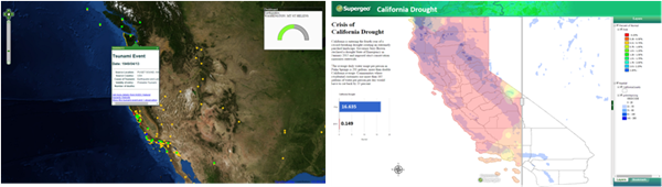
Integrating different sources of open data often generates great value and new information. For example, by integrating earthquake and tsunami locations with a coastal city vulnerability index, you will be able to find which cities are most vulnerable to tsunamis. Generally, data itself may not contain any information, but contrarily information is always derived from data . However, well-organized data is not easy to find, because there are many different formats for open data, including shp, geo, kml, kmz, csv, GeoJSON, and more. It is a challenge to integrate all these different formats together.

SuperGIS Server provides a powerful platform to integrate all common data formats into a single map. Moreover, it allows users to make their data accessible. For example, users can publish their data as OGC standards like WMS, WFS, and WMTS. By using SuperGIS Server, users will be able to integrate their data with the wealth of open data available online, and create more value.

So why don’t you start today? Explore the possibilities of open data, and grasp the world in your hand. Discover new information and generate greater value by using Supergeo products to integrate, visualize and analyze a world of open data.

On October 29, 2015, Supergeo will hold a webinar topic on open data. In this webinar, you will learn how to integrate various data formats with SuperGIS Server to make different applications, and get a one-month free trial after the webinar! Save your seat and join our free webinar on Thursday, 29th October 09:00 AM (GMT+1)
(Your local time): https://attendee.gotowebinar.com/register/8347980831060935682
Filed Under: Web Services Tagged With: SuperGIS Server

Editor’s Picks

geojobs

GeoJobs.BIZ Employment and Career Resource for GIS, Surveying, and Mapping Professionals

Join Esri, IBM, Amazon at the AT&T Mobile App Hackathon – Los Angeles

Salary Guide, Tips for Fastest Growing Industries & Top Technology Positions in Demand

DigitalGlobe Satellite Captures Dramatic Images of Alberta, Canada Oil Sands wildfire #fmmfire

See More Editor's Picks...

Recent Industry News

Why Bathroom Renovation Services Often Change More Than Just the Bathroom

May 20, 2026 By GISuser

The Drift Between Early Notes and Final Case Files in Abuse-Related Legal Support

April 29, 2026 By GISuser

Aerial Surveys Int’l and Global Marketing Insights to Present GEOINT 2026 Workshop on Multi-Domain Geospatial Fusion for Automated Infrastructure Monitoring

April 24, 2026 By GISuser

Why Timing Matters More Than You Think With Spray Seal (And Why People Often Get It Slightly Wrong)

April 22, 2026 By GISuser

Hot News

State of Data Science Report – AI and Open Source at Work

HERE and AWS Collaborate on New HERE AI Mapping Solutions

Virtual Surveyor Adds Productivity Tools to Mid-Level Smart Drone Surveying Software Plan

Categories

Copyright gletham Communications 2015 - 2026

Go to mobile version