GIS user technology news

News, Business, AI, Technology, IOS, Android, Google, Mobile, GIS, Crypto Currency, Economics

  • Advertising & Sponsored Posts
    • Advertising & Sponsored Posts
    • Submit Press
  • PRESS
    • Submit PR
    • Top Press
    • Business
    • Software
    • Hardware
    • UAV News
    • Mobile Technology
  • FEATURES
    • Around the Web
    • Social Media Features
    • EXPERTS & Guests
    • Tips
    • Infographics
  • Blog
  • Events
  • Shop
  • Tradepubs
  • CAREERS
You are here: Home / * PRESS / Earth Imaging - Remote Sensing / Proteus announces launch of professional satellite image procurement service

Proteus announces launch of professional satellite image procurement service

August 3, 2015 By GISuser

Proteus, a provider of satellite derived mapping and geospatial services, announces the official launch of their new professional satellite image procurement service.  Proteus employ dedicated expert account managers to provide customers with an end to end independent, fast and reliable satellite image procurement service. This service provides an approach to satellite imagery sales that is sensor agnostic, calling upon partnerships and agreements with the majority of satellite operators, Proteus has the capability to support all imagery purchasing requirements.
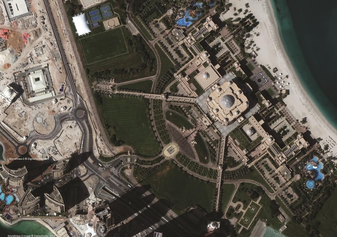
Proteus announces launch of professional satellite image procurement service

Image – Emirates Palace courtesy of ©DigitalGlobe Inc, taken on 14th November 2014 by WorldView-3 satellite at a resolution of 30cm. 

This service has developed from customer feedback when conducting imagery purchases, which indicated that the experience and knowledgeable advice provided by Proteus removed the stress and complexity they had previously experienced when attempting to complete a purchase and navigate the end user licences themselves.


“These days there are many satellite imagery providers, all with a range of products, resolutions, licencing conditions and costings. This can be overwhelming and time consuming for the end users, our aim is to break down all the technical barriers and find the best coverage for your area of interest. We strive to determine the most suitable imagery at the most competitive pricing” David Critchley, CEO of Proteus explained.

Proteus has now developed relationships with all the main satellite imagery suppliers and provide their customers with a comprehensive, sensor agnostic and personable service.

For more information www.proteusgeo.com/SatServices or email sales@proteusgeo.com

About Proteus – Based in Abu Dhabi, UAE, and Bristol, UK, Proteus is a leading geospatial consultancy, providing expert advice, services and product. Satellite imagery, derived geospatial analysis, environmental monitoring, laser scanning and mapping solutions.

www.proteusgeo.com Twitter – @proteusgeo

Filed Under: Earth Imaging - Remote Sensing Tagged With: Proteus

Top Press

The Global Expansion of Aueshah: A New Era of High Jewelry

April 11, 2026 By GISuser

KARACHI, PAKISTAN. The international luxury market is experiencing a profound shift. Consumers are increasingly rejecting mass-produced goods in favor of rarity, authenticity, and emotional depth. … [Read More...]

State of Data Science Report – AI and Open Source at Work

September 10, 2025 By GISuser

AI and Open Source at Work … [Read More...]

Topcon Announces Landmark Expansion of Topnet Live Network Across USA

January 26, 2025 By GISuser

LIVERMORE, Calif.---Topcon Positioning Systems has announced a significant expansion of its Topnet Live reference station network, introducing 200 new geodetic stations strategically positioned across … [Read More...]

Space Flight Laboratory (SFL) Announces Launch and Deployment of NorSat-4 Maritime Monitoring Microsatellite

January 19, 2025 By GISuser

Seventh Satellite Developed by SFL for Norway … [Read More...]

HERE and BMW Group extend partnership on AI-powered mapping system

January 8, 2025 By GISuser

HERE and BMW Group extend partnership on AI-powered mapping system for automated driving and enhanced road safety … [Read More...]

Everest Base Camp Helicopter Tour, Helicopter Return Trek, and Manaslu Circuit Trek: Which Nepal Adventure Is Right for You?

November 6, 2026 By GISuser

Almost everyone planning a Nepal trip runs into the same wall. You want the big mountains, you have a fixed number of days, and every itinerary you read seems to promise something … [Read More...]

SFL Missions Inc. Confirms Successful Deployment of Six HawkEye 360 Radio Frequency Detection Satellites with Advanced Capabilities

October 27, 2026 By GISuser

MĀHIA, New Zealand, 26 October 2026 – SFL Missions Inc. today confirmed the successful deployment of six radio frequency (RF) detection and geolocation satellites for HawkEye 360 … [Read More...]

Canadian-Built RoadEng 12 Uses AI to Find the Best Location for New Resource and Rural Roads

October 17, 2026 By GISuser

Vancouver, BC, Canada, October 15, 2026 – North Vancouver-based Softree Technical Systems today released RoadEng Version 12, used in more than 75 countries to locate and design … [Read More...]

Beyond the Map: How AI Image and Video Generation Is Changing Geospatial Communication

October 14, 2026 By GISuser

Ask anyone who has shipped a GIS project what the hardest part was, and the answer is rarely the spatial analysis. It is almost always the communication. A site suitability … [Read More...]

From Maternity to Everyday Wear: Building a Wardrobe That Grows With You

October 14, 2026 By GISuser

When I think about maternity clothing, I feel the biggest mistake is buying too many things at once. During pregnancy, your body keeps changing, and something that fits well today … [Read More...]

Copyright gletham Communications 2015 - 2026

Go to mobile version